Systems and methods for remote monitoring of weather

Inactive Publication Date: 2010-04-29
HONEYWELL INT INC
View PDF20 Cites 7 Cited by
  • Summary
  • Abstract
  • Description
  • Claims
  • Application Information

AI Technical Summary

Problems solved by technology

Aircraft travelling along a flight path typically traverse relatively long distances.
However, some segments of the flight path have no timely weather information available at all.
However, supplemental weather information from other sources may not be available for some segments of the flight path.
When the weather is unfavorable to the extent that successful performance of the mission is at risk, military commanders may choose to cancel or delay the mission.
In this situation, it is appreciated that the quality of weather information over the target area, or along some flight path segments leading to the target area, may be very poor or may not be available.
However, it is appreciated that using ground-based covert personnel for gathering weather information may be hazardous to the pilot because the information is of verbal content which is subjective.
Additionally, personnel may not be available to insert into the remote locations.
As another example, weather information over large bodies of water, such as an ocean or a sea, may not be available or may be stale.
However, their flight paths may not coincide with the flight path of the aircraft desiring weather information, or the PIREPS information may have been issued several hours earlier and may not be accurate when the aircraft is in the vicinity pertaining to the weather information described in the earlier issued PIREPS.

Method used


Image

  • Systems and methods for remote monitoring of weather
  • Systems and methods for remote monitoring of weather
  • Systems and methods for remote monitoring of weather

Examples


Embodiment Construction

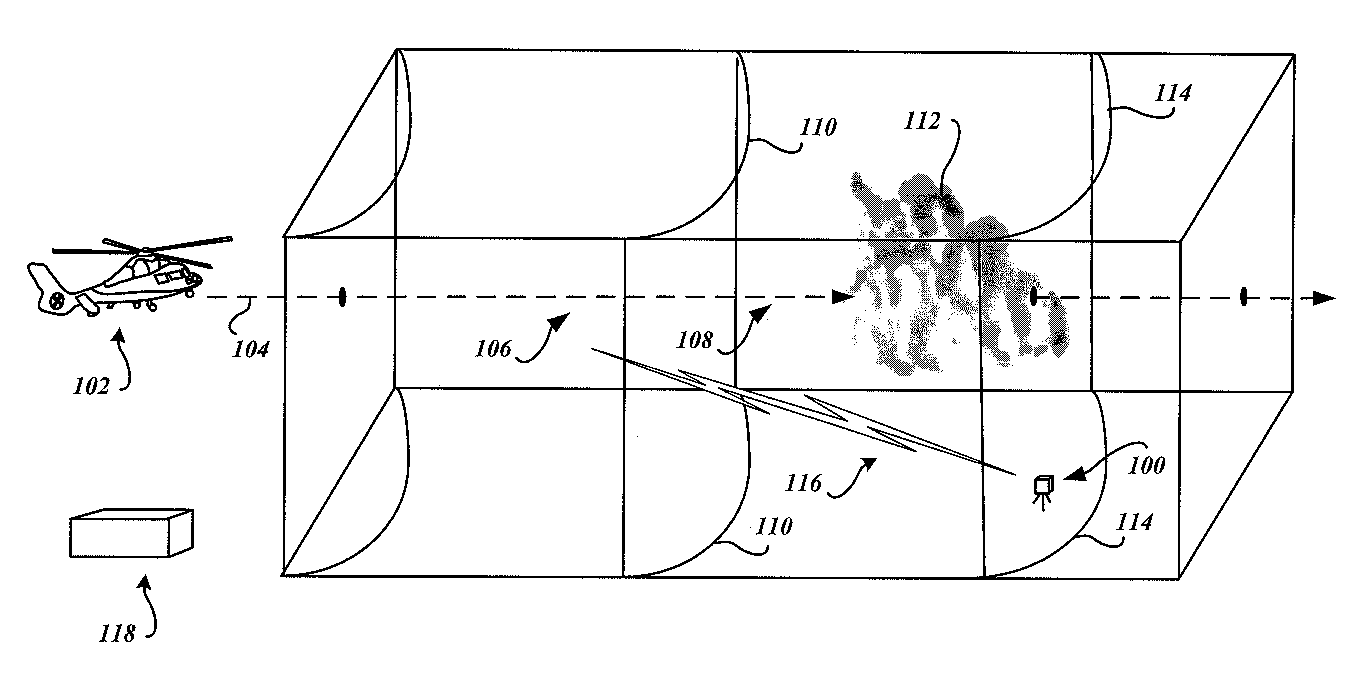
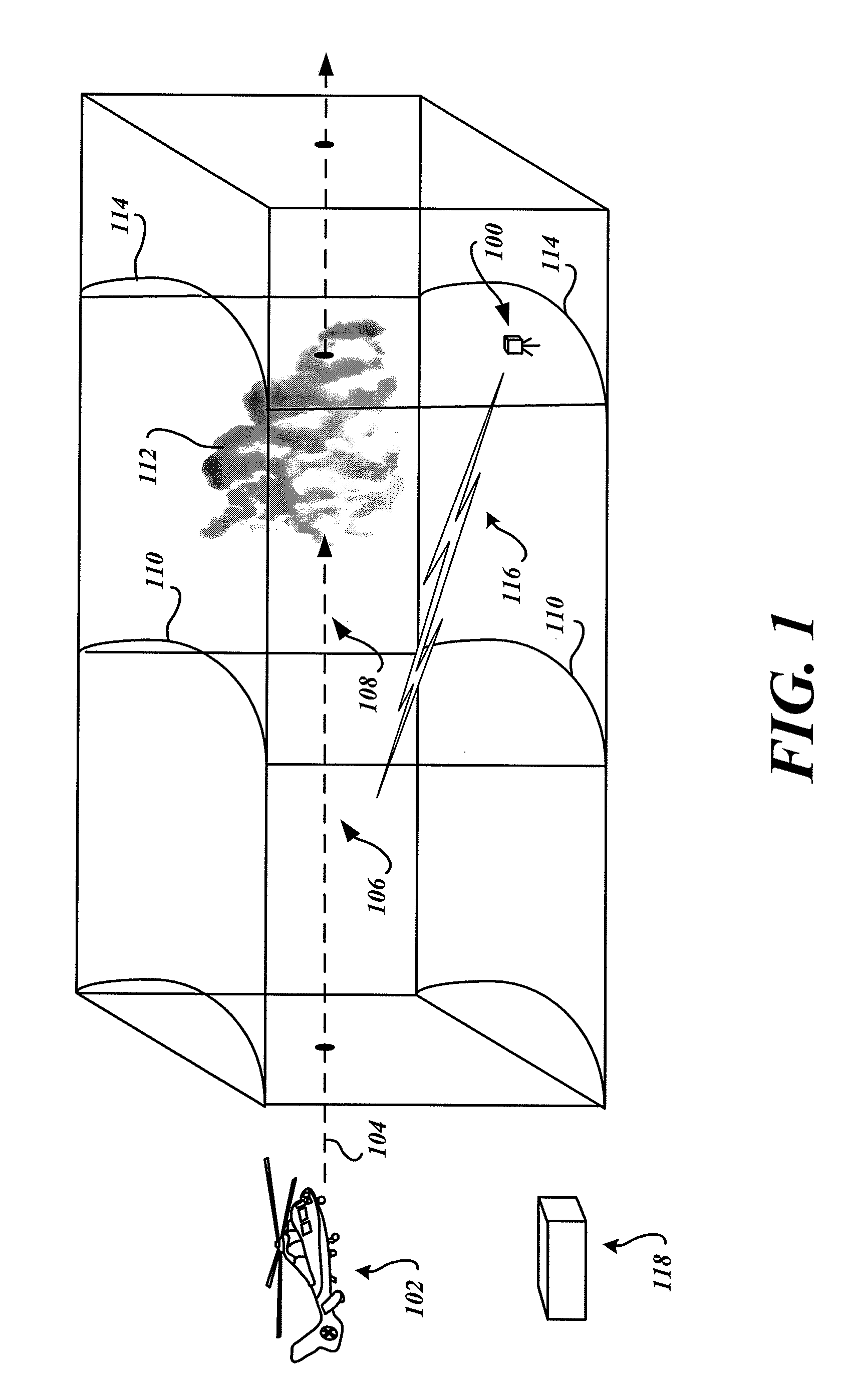
[0012]FIG. 1 is a conceptual illustration of a flight path monitored by an embodiment of the flight path segment monitoring system 100. An aircraft 102, illustrated as a helicopter, is illustrated as travelling along a planned flight path 104 having a discernable flight path segment 106 and a remote flight path segment 108.

[0013]The discernable flight path segment 106 extends to a range 110 where the aircraft crew is able to meaningfully discern visible weather phenomena or obstructions such as a mountain range. The discernable flight path segment 106 may be within the visual line-of-sight distance of the aircraft crew, and / or within the range of onboard detection devices such as a radar system.

[0014]Beyond the range 110, the aircraft crew is not able to visually discern weather phenomena or detect the weather phenomena with their onboard devices. For example, a relatively large cloud formation 112 is illustrated at a range 114 that is well beyond the range 110. Since the location o...


PUM


Abstract

Systems and methods are operable to capture images of weather along a portion of a flight path of an aircraft, and are operable to wirelessly communicate information corresponding to the captured images to the aircraft. An exemplary embodiment has at least one camera pointed in a direction corresponding to a portion of the flight path of the aircraft and configured to capture images of weather in proximity to the portion of the flight path, and has a transceiver configured to wirelessly communicate images captured by the at least one camera.

Description

BACKGROUND OF THE INVENTION[0001]Aircraft travelling along a flight path typically traverse relatively long distances. The aircraft crew may visually discern weather relatively close to the aircraft, and various onboard detection devices, such as a radar system, may provide information about weather conditions beyond the visual range of the aircraft crew. However, some segments of the flight path have no timely weather information available at all. Information about weather conditions along such remote segments of the flight path beyond the radar range of the aircraft may be available from other sources, such as ground stations and / or other aircraft. For example, other aircraft may provide weather information in the form of pilot reports (PIREPS). However, supplemental weather information from other sources may not be available for some segments of the flight path.[0002]For example, a combat mission performed by military aircraft is preferably performed during ideal weather conditio...

Claims


Application Information

Patent Timeline
IPC IPC(8): G01C23/00
CPCG01S7/06G01W1/08G01S13/953G01S13/86Y02A90/10
Inventor CORNETT, ALANMADDEN, CRAIG KEVINMEYERS, DAVID W.BECKER, ROBERT CHARLESSPOOR, DAVID TODD
Owner HONEYWELL INT INC
Why Eureka
Try Eureka