
Traffic information providing system and method for generating traffic information

a technology of traffic information and providing system, applied in the field of traffic information providing system, can solve the problems of inefficient data processing procedures for individual vehicle route guiding system, inability to estimate the travel time of non-provision links on a real-time basis, and huge memory capacity and corresponding processor capacity

Active Publication Date: 2008-12-18
XANAVI INFORMATICS
View PDF5 Cites 21 Cited by
  • Summary
  • Abstract
  • Description
  • Claims
  • Application Information

AI Technical Summary

Benefits of technology

[0007]One of the objects of the invention is to provide a traffic information providing system for creating traffic information to be used in a car navigation system which accurately estimates the travel speeds in free traffic flow conditions, using both real traffic data and map data. Moreover, the invention seeks to avoid the use of externally provided average travel speed data provided by map data providers as far as possible.
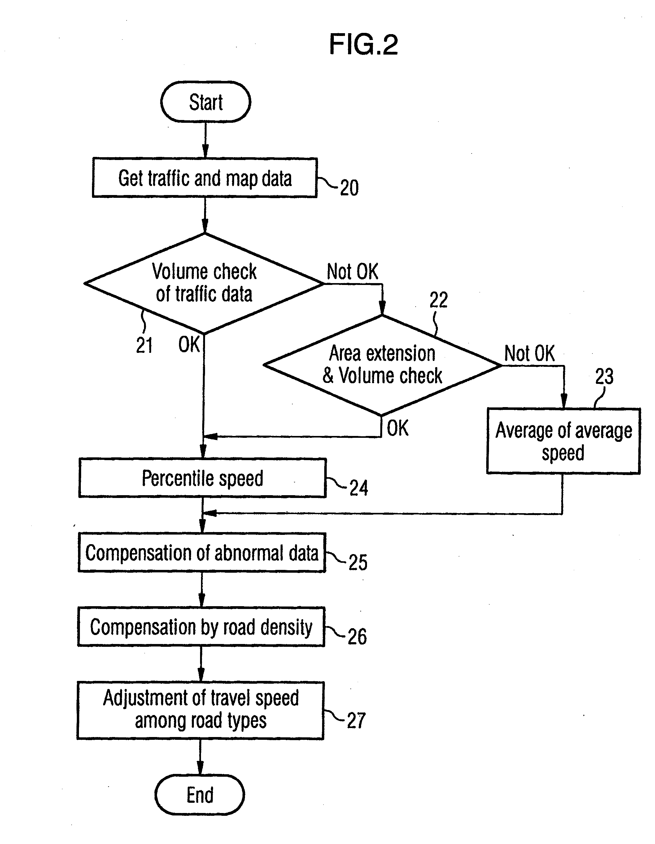
[0010]According to a further aspect of the invention, it is proposed that the data volume check unit is configured to increase the size of the target area, if a volume of traffic information data relating to links located in a previously chosen target is insufficient. Due to this configuration, the size of the target area can be stepwise adapted starting from low values, such that an excessively large target area can be surely avoided.
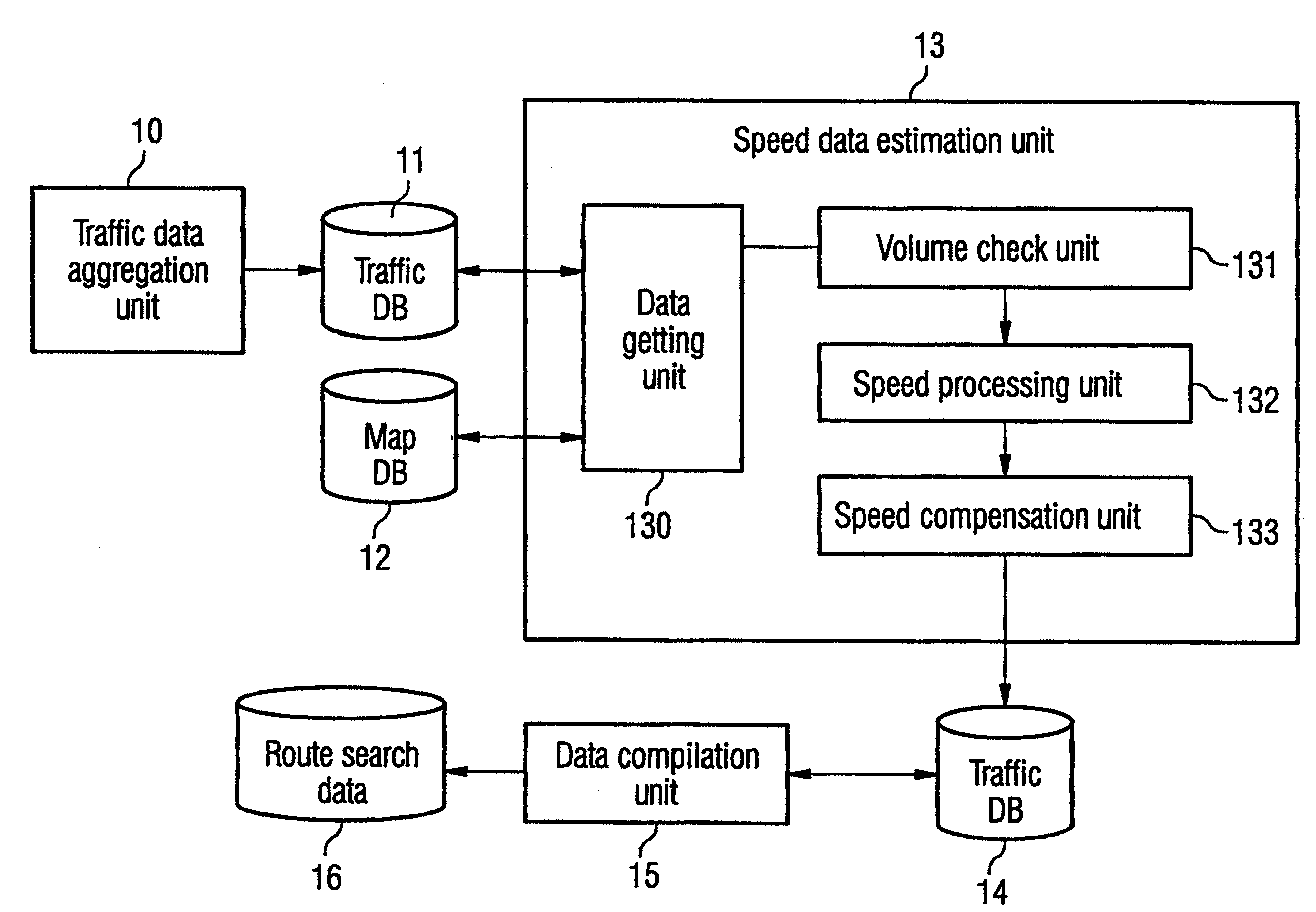
[0012]Moreover, it is proposed that the speed processing unit is configured to select a predetermined percentile speed from a distribution of speed values of speed values extracted from the traffic information data, wherein the speed values are relating to links of the same or similar road type and wherein the links are located in the same target area as the specific link. Moreover, the speed processing unit may be configured to set the value of a tentative speed of the specific links equal to the value of the predetermined percentile speed. If a percentile speed is selected, the influence of single abnormal data points may be weakened as compared to approaches where the tentative speed is selected based on an average and / or variance of the distribution of speed values.
[0014]Furthermore, it is proposed that the traffic information providing system is provided with a speed compensation unit being configured to calculate a speed value for a specific link dependent on a tentative speed value determined from a distribution of speed values. The distribution of speed values may be extracted from the traffic information data and / or from a data base of previously stored speed values. The speed compensation unit may calculate the speed value for the specific link by applying at least one correction function to the tentative speed value. It has turned out that estimates being directly based on the statistics and / or on the tentative value suffer from estimation errors being, among others, due to an erroneous measurement of traffic sensors and to erroneous data in the traffic information data. By selecting suitable speed compensation methods, the viability of the speed estimates may be highly increased.
[0017]A very simple and fast correction of the speed data may be achieved if the correction function is a piecewise linear function.
[0018]According to a further aspect of the invention, it is proposed that the speed compensation unit is configured to calculate a characteristic value for a road density within an area comprising the specific link and to determine the correction function depending on the characteristic value. It has turned out, that the road density of an area a route passes through strongly influences the travel time. A higher road density leads to a longer travel time and vice versa. Therefore, it is favorable to slightly augment the travel time estimates for areas with higher road density and to decrease the travel times for areas with lower road density. If such an approach is chosen, a route search algorithm using the traffic information data generated by the traffic information providing system according to the invention will tend to avoid areas with higher route density. The finally calculated route will circumvent such areas, which leads to a better result in the time estimates and to an increased driving comfort for the driver. In view of the above, it is particularly favorable, if the correction function has a slope that decreases when the road density decreases.

Problems solved by technology

However, traffic information is updated from moment to moment, and when traffic information data received are also included in the traffic information database used for calculating the average, a required memory capacity and correspondingly a required processor capacity becomes enormous.
In such a vehicle route guiding system, it is difficult to estimate a travel time of a non-provision link on a real-time basis, since the memory capacity and the processing performance are limited.
In addition, it is very inefficient to perform the same data processing procedures for individual vehicle route guiding systems over and over again.
In the technique disclosed in JP-A-2002-260142, even when a prediction error within a given probability is found, the error may fail to fall in a practical range.
For example, the prediction error within a probability of 90% may become larger than a mean value of the probability distribution of travel times, such that the thus acquired statistical information is not of any practical use.
Since the road traffic sensors are managed by public authorities, it is generally difficult to get such data.
However, the average travel times provided in the map data are often of poor quality, such that the estimates based on such average travel times often suffer from large estimation errors.
Since the travel time estimates for free traffic flow are often used as a basis for estimates under congested conditions, the estimation error will be propagated to further processing steps and tends to increase.

Method used


Image

  • Traffic information providing system and method for generating traffic information
  • Traffic information providing system and method for generating traffic information
  • Traffic information providing system and method for generating traffic information

Examples


Embodiment Construction

[0036]FIG. 1 is a schematic representation of a traffic information providing system for creating traffic information to be used in a car navigation system. The traffic information providing system comprises a speed data estimation unit 13 which processes traffic information data acquired from a traffic data base 11 and map data acquired from a map data base 12. The traffic information storage in the traffic data base 11 is provided by a traffic data aggregation unit 10.

[0037]The speed data estimation unit 13 processes the information in order to obtain speed data 14. The speed data is a data structure where links forming a map are associated with predetermined travel speeds or travel times. The speed data 14 estimated by the speed data estimation unit 13 is compiled by a data compilation unit 15 and subsequently stored in a storage device 16 comprising route search data. The route search data is traffic information which is usable by a car navigation system, in order to perform a r...


PUM


Abstract

The invention relates to a method for generating traffic information to be used in a car navigation system, comprising the steps of acquiring traffic information data including information relating to a travel time of links making up a road on a map and for acquiring map data relating to the link, the map data comprising at least information on a road type of the link and checking if a volume of the traffic information data available in is sufficient for performing a statistical estimate for the travel time. In order to enhance the traffic information generated, it is proposed to use the steps of checking if the volume of traffic information data relating to links located in a target area is sufficient and adapting a size of the target area depending on the amount of available traffic information data.

Description

BACKGROUND OF THE INVENTION[0001]The present invention relates to a traffic information providing system for creating traffic information to be used in a car navigation system. In particular, the invention relates to a traffic information providing system suitable for generating traffic information relating to free traffic flow conditions. Moreover, the invention relates to a method for generating traffic information to be used in a car navigation system, a data storage device storing traffic information generated according to the method of the invention and to a car navigation system comprising such a data storage device.[0002]The document US2005 / 0093720A1 teaches a traffic information providing system for creating traffic information to be used in a car navigation system. The traffic information providing system comprises a unit for getting traffic information data relating to a travel time of links making up a road on a map. The data getting unit moreover acquires map data relati...

Claims


Application Information

Patent Timeline
IPC IPC(8): G06G7/76
CPCG08G1/0104
Inventor YAMANE, KENICHIRO
Owner XANAVI INFORMATICS
Learn More