
Real-time modeling analysis of hazards data with large numbers of locations and with customized reporting and web-based delivery

a real-time modeling and analysis technology, applied in the field of data collection, analysis and reporting, can solve the problems of large quantity of hazards data available, inability to aggregate hazards data and mine, and affect human life and property, and achieve the effect of quick and easy harvesting

Inactive Publication Date: 2008-03-06
CORELOGIC SOLUTIONS
View PDF5 Cites 36 Cited by
  • Summary
  • Abstract
  • Description
  • Claims
  • Application Information

AI Technical Summary

Benefits of technology

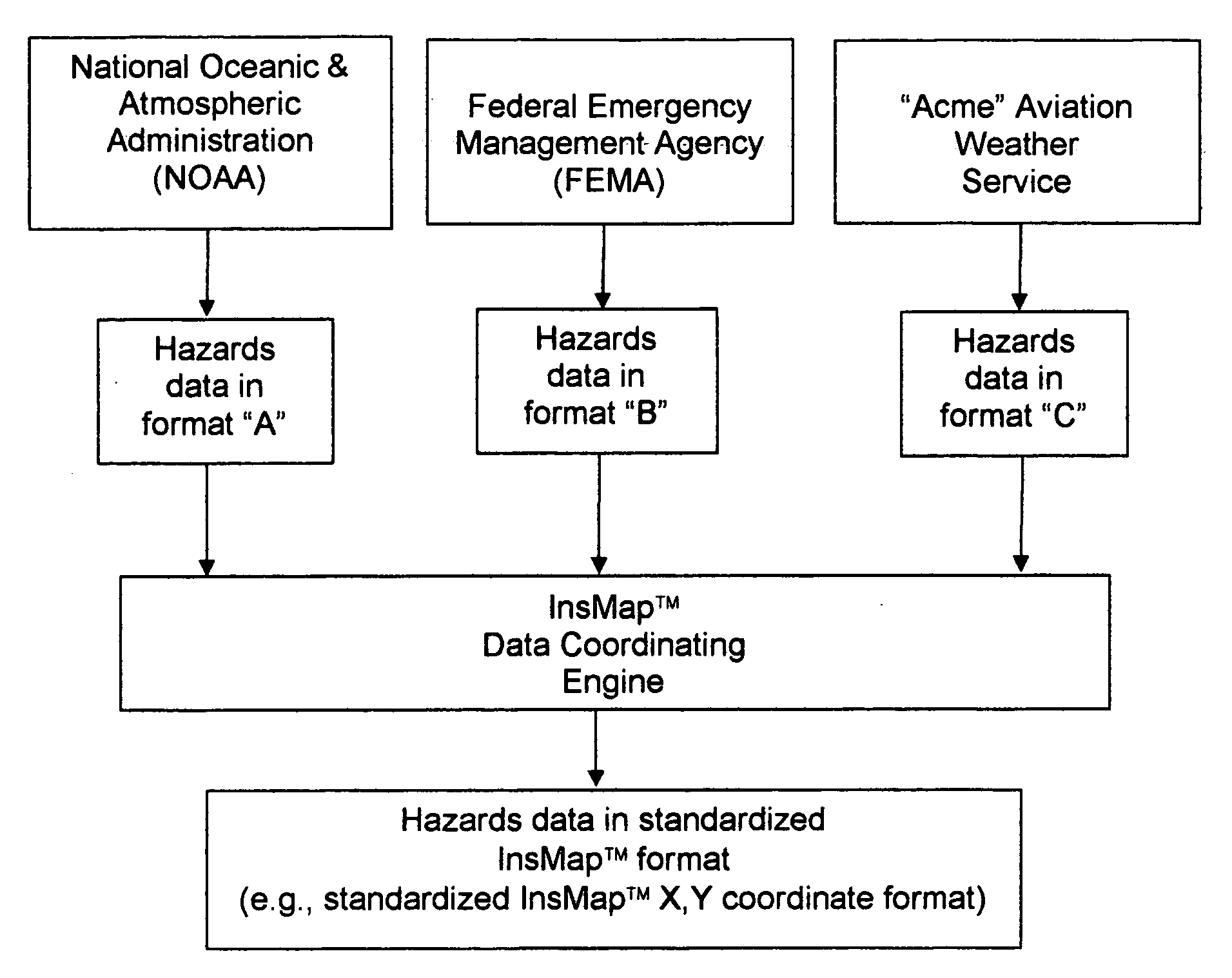
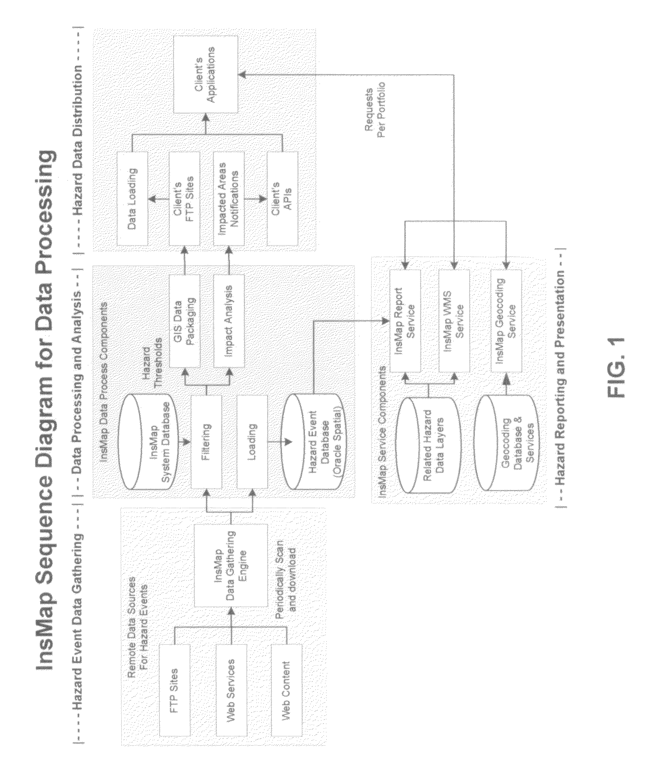
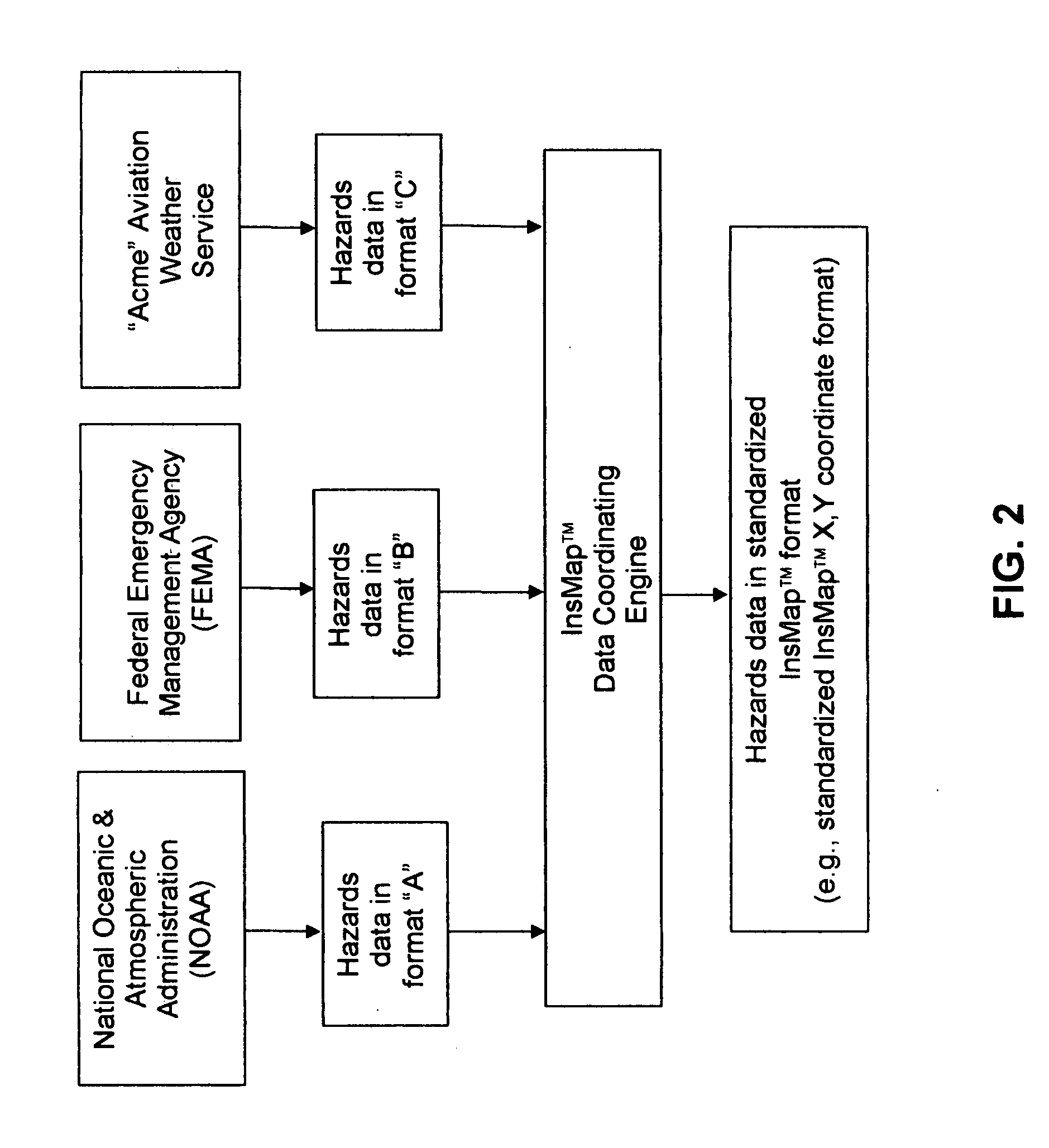
[0009]This and other objects are addressed by the present invention, which comprises a novel system for aggregating numerous, but disparate, specialized hazard data sets so as to provide a broad spectrum of hazards data, and then enabling selected data to be quickly and easily harvested according to the targeted interests of specific users. In this way, the present invention provides a particularly robust tool which can be used to gain insights into the aggregated hazards data which is not possible when reviewing any single hazards data set. By way of example but not limitation, the present invention provides a system to harness the numerous, but disparate, hazard data sets currently available from a variety of different sources and overlays them in real-time on any size portfolio of individual locations worldwide. In other words, the present invention makes it possible to monitor millions, or even hundreds of millions, of properties for their exposure to hazards.

Problems solved by technology

There are currently many hazards that affect human life and property, including weather (e.g., floods, hail, intense winds, etc.), earthquakes, wild fires, terrorism, etc.
However, each of these data sources tends to be relatively specialized, providing data for specific purposes and hence, generally providing data for only one or two natural phenomena.
Thus, a data source providing information regarding weather will not tend to provide information regarding earthquakes, and a data source providing information regarding wild fires will not tend to provide information regarding flooding, etc.
As a result, there is currently a large quantity of hazards data available, but it tends to be relatively segregated according to the specific applications for which it is assembled.
There is currently no easy way to aggregate this hazards data and then mine it for purposes which are separate from those for which the individual databases were created.
In other words, while numerous hazard data sets are currently available, there is no simple way to aggregate these disparate hazard data sets and then utilize them, flexibly and selectively, for a wide range of particular needs.
The foregoing deficiencies with currently-available hazard data sets becomes particularly problematic when attempting to conduct modeling analysis of hazards data in order to predict property insurance exposures and, in extreme cases, life insurance exposures.
In other words, insurance underwriters currently have no simple way to harness the numerous, but disparate, hazard data sets currently available and utilize them in a coordinated fashion so as to predict insurance exposures across a broad geographic region.

Method used


Image

  • Real-time modeling analysis of hazards data with large numbers of locations and with customized reporting and web-based delivery
  • Real-time modeling analysis of hazards data with large numbers of locations and with customized reporting and web-based delivery
  • Real-time modeling analysis of hazards data with large numbers of locations and with customized reporting and web-based delivery

Examples


Embodiment Construction

In General

[0027]The present invention provides a real-time monitoring system for determining potential loss exposure to hazards. More particularly, this system can be used to monitor virtually any location (or any number of locations) for any hazard (or any group of hazards) for which hazards data are available. Furthermore, this system can be used to predict, by location (e.g., by address, by targeted geographic region, by latitude / longitude, by specific X,Y coordinates, by census blocks, by geographic boundary lines, etc.), the potential loss exposure from specific hazard events such as floods, hurricanes, tornadoes, etc. In addition, this new system can be integrated with existing database, analysis and / or visual display systems so as to provide users with dramatically-enhanced levels of information.

[0028]For the purposes of the present application, the real-time system for monitoring hazards and determining potential loss exposure from those hazards will sometimes hereinafter be...


PUM


Abstract

A system for monitoring hazards and determining potential loss exposure resulting from those hazards, the system comprising:a first user input component for permitting a user to specify at least one geographic location to be monitored;a second user input component for permitting a user to specify at least one hazard parameter to be monitored for the at least one monitored location;a first data acquisition component for acquiring hazard data for the at least one monitored location, wherein the first data acquisition component is configured to acquire the data from at least two disparate data sources and aggregate that data in a seamless data set;a second data acquisition component for acquiring data regarding entities associated with the at least one monitored location;an analytical engine for determining the potential loss exposure to the entities associated with the at least one monitored location resulting from the occurrence of hazards at the at least one monitored location; anda reporting engine for reporting the results of the analytical engine to a user.A method for monitoring hazards and determining potential loss exposure resulting from those hazards, the method comprising:specifying (i) at least one geographic location to be monitored, and (ii) at least one hazard parameter to be monitored for the at least one monitored location, and acquiring (a) hazard data for the at least one monitored location, wherein the acquired hazard data is from at least two disparate data sources, and aggregating the hazard data into a seamless data set, and (b) acquiring data regarding insured entities associated with the at least one monitored location;determining potential loss exposure to the entities associated with the at least one monitored location resulting from the occurrence of hazards at the at least one monitored location; andreporting the determined potential loss exposure to a user.

Description

REFERENCE TO PENDING PRIOR PATENT APPLICATION[0001]This patent application claims benefit of pending prior U.S. Provisional Patent Application Ser. No. 60 / 812,331, filed Jun. 9, 2006 by James A. Aylward for REAL TIME MODELING ANALYSIS OF HAZARDS DATA WITH LARGE NUMBERS OF LOCATIONS (INSMAP) WITH WEB BASED DELIVERY AND CUSTOMIZED REPORTING (Attorney's Docket No. HDM-12 PROV), which patent application is hereby incorporated herein by reference.FIELD OF THE INVENTION[0002]The present invention relates to data collection, analysis and reporting in general, and more particularly to hazard data collection, analysis and reporting.BACKGROUND OF THE INVENTION[0003]There are currently many hazards that affect human life and property, including weather (e.g., floods, hail, intense winds, etc.), earthquakes, wild fires, terrorism, etc. Data relating to such hazards (“hazards data”) are currently available through a variety of government agencies (e.g., the National Oceanic & Atmospheric Adminis...

Claims


Application Information

Patent Timeline
IPC IPC(8): G01W1/00
CPCG06Q40/08G01W1/10Y02A90/10
Inventor AYLWARD, JAMES A.
Owner CORELOGIC SOLUTIONS
Learn More