
Device for monitoring the integrity of information delivered by a hybrid ins/gnss system

a hybrid ins/gnss and information delivery technology, applied in surveying and navigation, navigation instruments, instruments, etc., can solve problems such as circuits with satellite failure detection thresholds

Inactive Publication Date: 2007-07-05
THALES SA
View PDF17 Cites 56 Cited by
  • Summary
  • Abstract
  • Description
  • Claims
  • Application Information

AI Technical Summary

Benefits of technology

[0018] It is an object of the present invention to monitor the integrity of the position and speed information of a hybrid system comprising an inertial unit readjusted with the help of a GNSS receiver by using the resolved position and speed of the bearer obtained from the GNSS receiver.

Problems solved by technology

Advantageously, the test circuits have satellite-failure detection thresholds that result from statistical tests taking account of the covariance associated with the type of positioning error concerned.

Method used


Image

  • Device for monitoring the integrity of information delivered by a hybrid ins/gnss system
  • Device for monitoring the integrity of information delivered by a hybrid ins/gnss system
  • Device for monitoring the integrity of information delivered by a hybrid ins/gnss system

Examples


Embodiment Construction

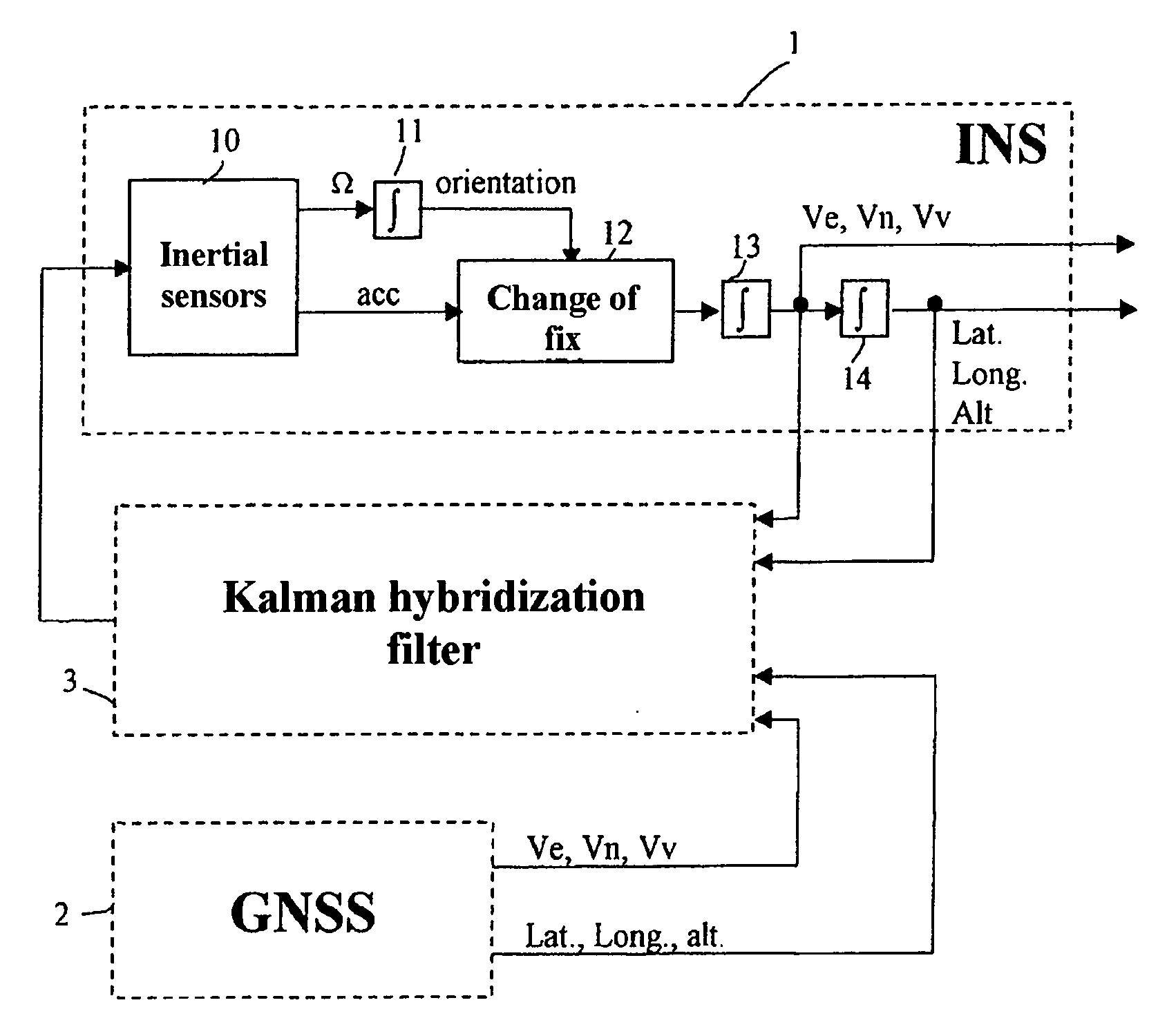
[0032]FIG. 1 shows the architecture of a hybrid positioning system equipped with an inertial unit 1 and a GNSS satellite positioning receiver 2, said to be in closed loop mode and of loose type, because it uses resolved position (latitude, longitude and altitude) and speed (speed north, speed east and speed vertical) information concerning the bearer delivered by the GNSS receiver 2 for readjusting of the inertial unit INS 1.

[0033] As shown, the inertial unit comprises a set 10 of inertial sensors (accelerometers and gyrometers) and computation circuits, called virtual platform PFV, to perform the position, attitude and speed computations on the outputs of the inertial sensors. The virtual platform PFV mainly comprises a set of integrators 11 operating on the signals Ω of the gyrometers in order to deduce from them the attitude of the bearer, a fix changer 12 used, based on the knowledge of the orientation of the bearer (attitude), to express within a geographic fix linked to the E...


PUM


Abstract

The device is for monitoring the integrity of the position and speed information supplied by a hybrid system comprising an inertial unit INS readjusted using a GNSS satellite positioning receiver by means of a Kalman hybridization filter using a readjustment gain K and an evolution matrix F. It includes a satellite problem-detector circuit comprising a bank of predictor / estimator filters which uses the gain K and the evolution matrix F of the Kalman hybridization filter, each filter observing the deviation between the positioning point obtained from the N visible satellites, in the form of geographic coordinates, delivered by the GNSS receiver and one of the positioning points P(N−1) / i, also in the form of geographic coordinates, delivered by this same GNSS receiver, obtained by using N−1 of the N visible satellites for resolution, and test circuits comparing the states of the predictor / estimator filters with their variances and detecting a satellite failure when a test is positive, the deviation found being greater than a detection threshold.

Description

CROSS-REFERENCE TO RELATED APPLICATIONS [0001] The present Application is based on International Application No. PCT / EP2005 / 050390, filed on Jan. 31, 2005 and priority is hereby claimed under 35 USC § 119 based on this application.BACKGROUND OF THE INVENTION [0002] 1. Field of the Invention [0003] The invention relates to the monitoring of the integrity of position and speed information obtained from a hybridization between an inertial unit and a satellite positioning receiver. It more specifically relates to a navigation device known in the art by the name of INS / GNSS (standing for “Inertial Navigation System” and “Global Navigation Satellite System”) that is hybridized in closed loop mode, the hybridization being said to be loose because it is implemented on geographic lines. [0004] 2. Description of the Related Art [0005] An inertial unit is made up of a set of inertial sensors (gyrometric sensors and accelerometric sensors) associated with electronic processing circuitry. A comp...

Claims


Application Information

Patent Timeline
Patent Type & Authority Applications(United States)
IPC IPC(8): G01C21/00G01S19/23G01C21/16G01S1/00
CPCG01S19/23G01C21/16G01C21/188G01C21/165
Inventor COATANTIEC, JACQUESLESOT, BERTRAND
Owner THALES SA
Learn More