
Method for combined use of a local rtk system and a regional, wide-area, or global carrier-phase positioning system

a technology of carrier-phase positioning system and local rtk system, which is applied in the direction of instruments, measurement devices, electrical equipment, etc., can solve the problems of only determining the whole cycle ambiguity and the long elapsed time of the navigation receiver

Active Publication Date: 2005-07-14
DEERE & CO
View PDF6 Cites 52 Cited by
  • Summary
  • Abstract
  • Description
  • Claims
  • Application Information

AI Technical Summary

Benefits of technology

The present patent application describes a method that combines the use of RTK and WADGPS navigation techniques to overcome their limitations. The method uses a known position of a user receiver to initialize the floating ambiguity values in a WADGPS system, which allows for accurate range measurements even when the user receiver is moving. This method also allows for very accurate PVT solutions when the RTK system is unavailable or inaccurate. Overall, this method provides a more practical and high-accuracy solution for positioning and navigation purposes.

Problems solved by technology

The primary disadvantage of the WADGPS technique is that the navigation receiver takes a long elapsed time (often more than an hour) to determine the floating ambiguity values, which are required to convert the carrier-phase measurements into accurate range measurements.
The primary disadvantages of the RTK technique are that it requires a real-time (normally line of site) data link between a user GPS receiver and a reference GPS receiver and that the whole-cycle ambiguity can only be determined when the separation distance between reference GPS receiver and user GPS receiver is relatively short.

Method used


Image

  • Method for combined use of a local rtk system and a regional, wide-area, or global carrier-phase positioning system
  • Method for combined use of a local rtk system and a regional, wide-area, or global carrier-phase positioning system
  • Method for combined use of a local rtk system and a regional, wide-area, or global carrier-phase positioning system

Examples


Embodiment Construction

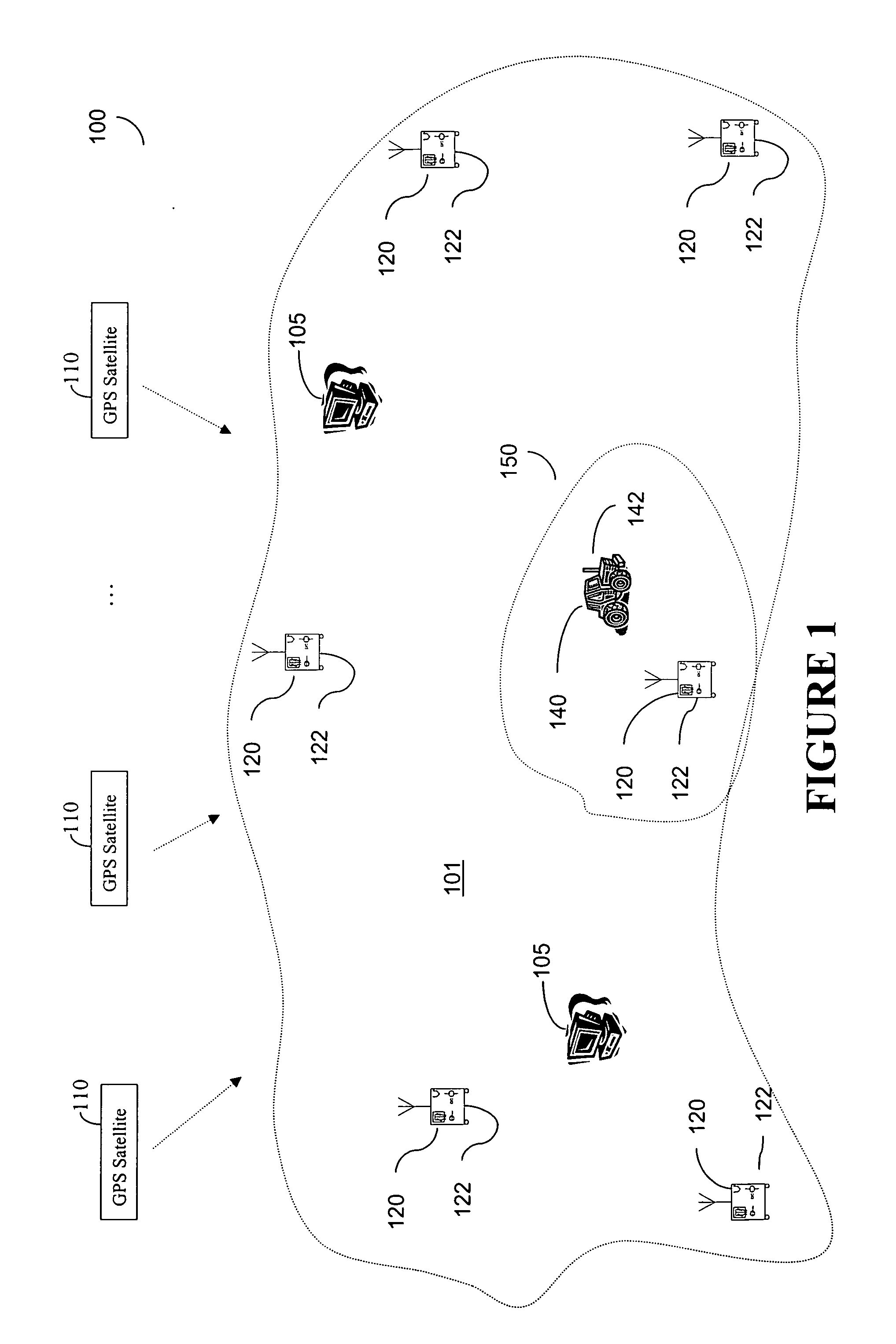
[0018]FIG. 1 illustrates a wide-area or global differential GPS (WADGPS) system 100 according to one embodiment of the present invention. As shown in FIG. 1, the WADGPS system 100 includes a network of reference stations 120 each having a GPS receiver 122, and one or more processing hubs 105. The reference stations 120 continuously provide raw GPS observables to the hub 105 for processing. These observables include GPS code and carrier phase measurements, ephemerides, and other information obtained according to signals received from a plurality of satellites 110 at the reference stations 120. The reference stations 120 are placed at known locations across a wide area 101, such as a continent, for a wide-area DGPS system, or across the globe for a global DGPS network. The hubs 105 are facilities at which the GPS observables are processed and DGPS corrections are computed. If multiple independent hubs are provided, it is preferred that they are geographically separated and operate in ...


PUM


Abstract

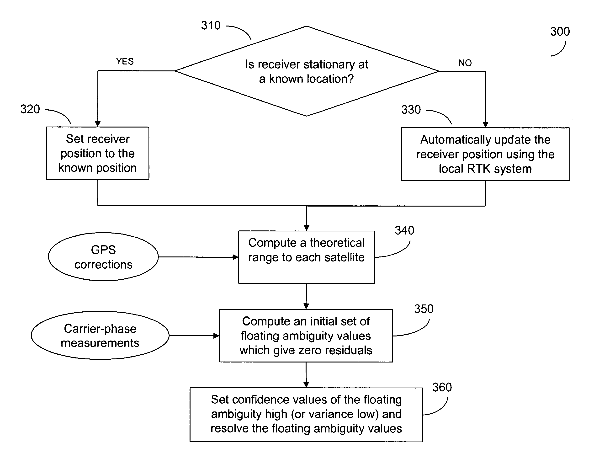
The present invention includes a method for a combined use of a local RTK system and a regional, wide-area, or global differential carrier-phase positioning system (WADGPS) in which disadvantages associated with the RTK and the WADGPS navigation techniques when used separately are avoided. The method includes using a known position of a user receiver that has been stationary or using an RTK system to initialize the floating ambiguity values in the WADGPS system when the user receiver is moving. Thereafter, the refraction-corrected carrier-phase measurements obtained at the user GPS receiver are adjusted by including the corresponding initial floating ambiguity values and the floating ambiguity values are treated as well known (small variance) in subsequent processes to position the user receiver in the WADGPS system.

Description

[0001] The present invention relates generally to technologies associated with positioning and navigation using satellites, and more particularly to resolving carrier floating ambiguity in a regional, wide-area, or global carrier-phase positioning and / or navigation system. BACKGROUND OF THE INVENTION [0002] The global positioning system (GPS) uses satellites in space to locate objects on earth. With GPS, signals from the satellites arrive at a GPS receiver and are used to determine the position of the GPS receiver. Currently, two types of GPS measurements corresponding to each correlator channel with a locked GPS satellite signal are available for civilian GPS receivers. The two types of GPS measurements are pseudorange, and integrated carrier phase for two carrier signals, L1 and L2, with frequencies of 1.5754 GHz and 1.2276 GHz, or wavelengths of 0.1903 m and 0.2442 m, respectively. The pseudorange measurement (or code measurement) is a basic GPS observable that all types of GPS r...

Claims


Application Information

Patent Timeline
Patent Type & Authority Applications(United States)
IPC IPC(8): G01S19/43G01S19/44G01S19/48
CPCG01S19/44
Inventor SHARPE, RICHARD T.NELSON, FREDERICK W.PICKETT, TERENCE D.HATCH, RONALD R.YANG, YUNCHUN
Owner DEERE & CO
Learn More