Method and system for determining the point location of a stopped vehicle on a storage track, using virtual beacons

Active Publication Date: 2022-08-16
THALES SA
View PDF5 Cites 0 Cited by
  • Summary
  • Abstract
  • Description
  • Claims
  • Application Information

AI Technical Summary

Benefits of technology

The invention provides a method and system for determining the point location of a train without having to move it. The technical effect is that multiple hypotheses can be tested to find the best parking position for the train.

Problems solved by technology

The drawback of the use of contactors or RFID beacons in this system for determining point location is the fact that such a system requires substantial infrastructure, in terms of the number of RFID beacons required to be installed on the storage tracks and of the maintenance of said installed beacons.
Another drawback is the fact that before being able to be located by an RFID beacon or a contactor the train must start a “blind” movement at very low speed, this requiring prior authorization by the authorities in charge of traffic management.
However, the always possible presence of distortions of the received signal, which may be related to multipaths, or to local interference, the train being stopped, may induce position errors much larger than the spacing between tracks, thus risking making the determination of the track corrupted in terms of an integrity loss, even after a long integration (in terms of integration duration) of the computed position.
Generally, the main known limitations, related to use of a standard GNSS approach, are the following:the availability of the GNSS signals may be insufficient in the case of land vehicles stored on the ground, for reasons of signal masking or of unavailability of satellite signals; and / orthe quality of the measurements may be degraded, this degradation taking the form of a measurement bias due to the effect of propagation disruptions, such as for example multipaths or local interference in the reception environment; and / orthe precision and integrity of the location measurements may be substantially lower than that provided by a more robust physical beacon, and does not allow the safety objectives sought for rail traffic, in particular those as regards the delivered position having a SIL4 integrity level (acronym of Safety Integrity Level 4) such as defined in standard IEC-61508, to be achieved.
A first technical problem is therefore to provide a method and system for determining the point location of a vehicle, stopped on a storage track, using a virtual beacon, associated with said departure track, that it is sought to identify before departure, which allow, via use alone of the measurements delivered by a standard GNSS receiver, the departure track on which the stored train is found to be identified, with a high safety integrity level, among a set of departure tracks, which are close to one another, after the stopped train has been turned on at said departure track.
A second technical problem is to provide a method and system for determining the point location of a vehicle, stopped on a storage track, using a virtual beacon, associated with said departure track, that it is sought to identify before departure, which allow, via use alone of the measurements delivered by a standard GNSS receiver, the departure track on which the stored train is found to be identified, among a set of departure tracks which are close to one another, and which guarantee a high integrity performance and a high robustness performance with respect to the effect of propagation disruptions or local interference in the reception environment.

Method used


Image

  • Method and system for determining the point location of a stopped vehicle on a storage track, using virtual beacons
  • Method and system for determining the point location of a stopped vehicle on a storage track, using virtual beacons
  • Method and system for determining the point location of a stopped vehicle on a storage track, using virtual beacons

Examples


embodiment 302

[0108]According to FIG. 4 and a first particular embodiment 302 of the method for determining the point location of the train of FIG. 3, the locating method 302 comprises the initialization first step 206 of FIG. 3, a first loop 312 of substeps 314, 316, 318, 320, 322 in which reset times tk of the second set, parameterized by the index k, which varies from 1 to Nk, are scanned, and the fourth step 212 of FIG. 3.

[0109]Before the first loop 312 is executed, the index k of iteration of the reset times tk is set to 1 beforehand in the step 310 of initialization of the execution of the first loop 312.

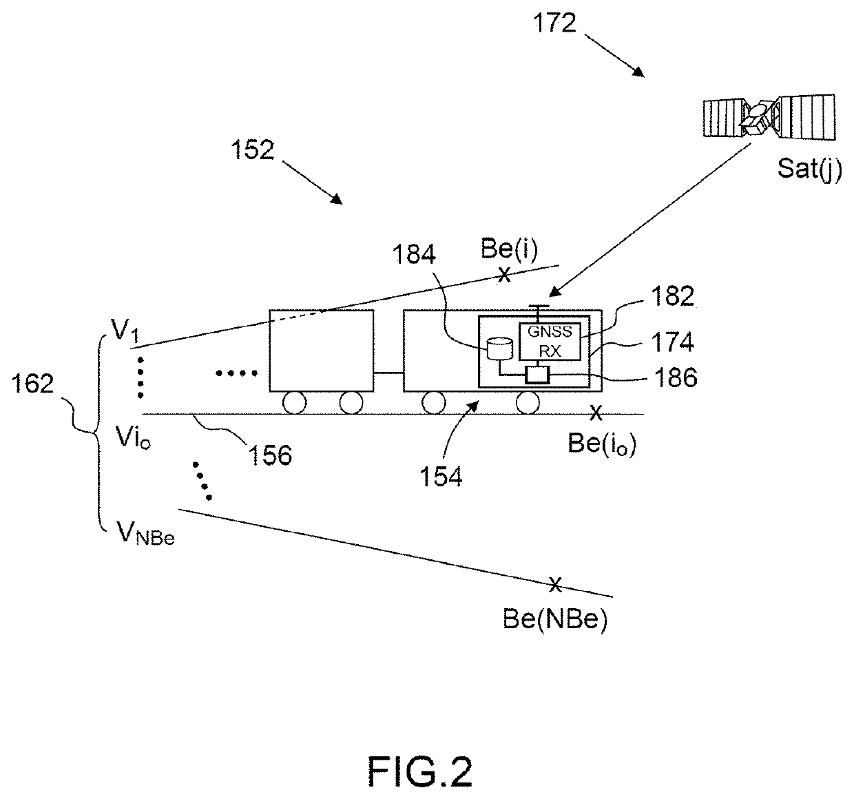
[0110]In the first substep 314, k being set, the GNSS signals of GNSS replicas Ci(j, tk) expected, at the time tk, and at the position P(i) of the virtual beacon Be(i), are generated, for all the satellites Sat(i, j, k) visible from the virtual beacon Be(i) at the time tk, by computation, the first set of virtual beacons Be(i) being scanned via the index i (which varies from 1 to NBe) of a ...

second embodiment

[0127]In FIG. 6, an example of a modular architecture of a system 402 for partially implementing the method 352 for determining point location according to FIG. 5 is illustrated.

[0128]The modular architecture shown here comprises a set 412 of modules for implementing the sixth substep 358 and the seventh substep 360, the modules possibly being software modules executed by at least one electronic processing unit, or hardware electronic modules performing particular functions.

[0129]The modules for implementing the sixth substep 358 are produced using a battery of numerically controlled oscillators 4221, . . . 422j, . . . 422Nj (NCOs) that are arranged in parallel to generate, at the local reset time tk, expected replica PRN codes Ci(j, tk) of the satellites visible from the position P(i) of the virtual beacon Be(i), which are designated by an index j in this set of visible satellites, j varying from 1 to Nj, Nj being the total number Nj of visible satellites.

[0130]The modules for impl...


PUM


Abstract

A method for determining the point location of a vehicle stopped on one storage track among a set of storage tracks, using virtual beacons is provided. It determines and compares the likelihood of a plurality of hypotheses as to the stopped location of the vehicle, corresponding to a first set of NBe predefined virtual beacons Be(i), i varying from 1 to NBe, the respective positions of which are known in an amount of one virtual beacon per storage track, by correlating the GNSS geo-positioning signals received at various synchronization reset times of a second set by the GNSS receiver located on board the vehicle with predicted GNSS geo-positioning signals of replicas expected for the various positions of the virtual beacons of the first set at the various times. The detected holding position of the vehicle is the position that corresponds to the maximum likelihood.

Description

CROSS-REFERENCE TO RELATED APPLICATIONS[0001]This application is a National Stage of International patent application PCT / FR2019 / 000096, filed on Jun. 13, 2019, the disclosure of which is incorporated by reference in its entirety.FIELD OF THE INVENTIONBACKGROUND[0002]The present invention relates to the field of satellite geolocation. The invention more particularly relates to a method and system for determining the point location, i.e. determining instantaneously or in real time the time-stamped position, of a stopped vehicle held on one storage and / or departure track among a set of storage tracks, using virtual beacons.[0003]The present invention also relates to a device for determining the point location of a vehicle parked and stopped on a departure track, said device being integrated into the system for determining point location according to the invention, and relates to a computer-program product to be executed or executed by said device for determining point location.[0004]T...

Claims


Application Information

Patent Timeline
IPC IPC(8): G01S19/50G01S19/40B61L25/02G01S19/25
CPCB61L25/025G01S19/256G01S19/40G01S19/50B61L2205/04G01S19/42
Inventor REVOL, MARC
Owner THALES SA
Why Eureka
Try Eureka