Robot navigation method and system based on multi-line laser radar

A multi-line laser and navigation system technology, applied in the field of robot navigation system and system based on multi-line laser radar, can solve the problems of sparse points, uneven distribution, ignoring path information, etc., to improve accuracy and improve path planning Effects on obstacle avoidance, good generalization and robustness

Pending Publication Date: 2022-05-13
SHANDONG UNIV
View PDF0 Cites 2 Cited by
  • Summary
  • Abstract
  • Description
  • Claims
  • Application Information

AI Technical Summary

Problems solved by technology

However, these methods still process the bird's-eye view of point cloud data in the Cartesian coordinate system, which will result in dense points close to the radar, while distant points are sparse and unevenly distributed.
In addition, most existing methods for processing point cloud data ignore the information of visibility, that is, only the position (x, y, z) of the point cloud is considered, but the path information from the sensor to the point is ignored.

Method used


Image

  • Robot navigation method and system based on multi-line laser radar
  • Robot navigation method and system based on multi-line laser radar
  • Robot navigation method and system based on multi-line laser radar

Examples


Embodiment 1

[0039] In one or more implementations, a multi-line lidar-based robot navigation method is disclosed, which mainly includes the following process:

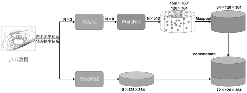
[0040] (1) Obtain the point cloud data in the set area around the robot, and convert the point cloud data from the Cartesian coordinate system to the form of polar coordinates;

[0041] (2) Calculate the high-dimensional feature and the visibility feature of each point cloud data respectively, and superimpose the visibility feature and the high-dimensional feature data to obtain the total feature extracted by fusion;

[0042] Specifically, through preprocessing operations, each point cloud data is composed of The three dimensions expand to become eight dimensions, of which, Respectively represent the relative radius, corner and height from this point to the center of the fan column to which it belongs; r represents the radius, Represents the angle, z represents the height, x represents the length of the x-axis, and y repres...

Embodiment 2

[0081] In one or more implementations, a robot navigation system based on multi-line lidar is disclosed, including:

[0082] A data acquisition module, configured to acquire point cloud data in a set area around the robot, and convert the point cloud data from a Cartesian coordinate system to a form of polar coordinates;

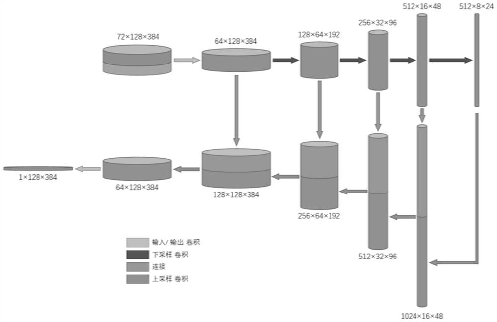
[0083] The perception module is used to separately calculate the high-dimensional features and visibility features of each point cloud data, and superimpose the visibility features and high-dimensional feature data to obtain the total features extracted by fusion; use U-Net as the basic framework for Divide the task, obtain the feasible area in the set area around the current robot, and perform normalization processing;

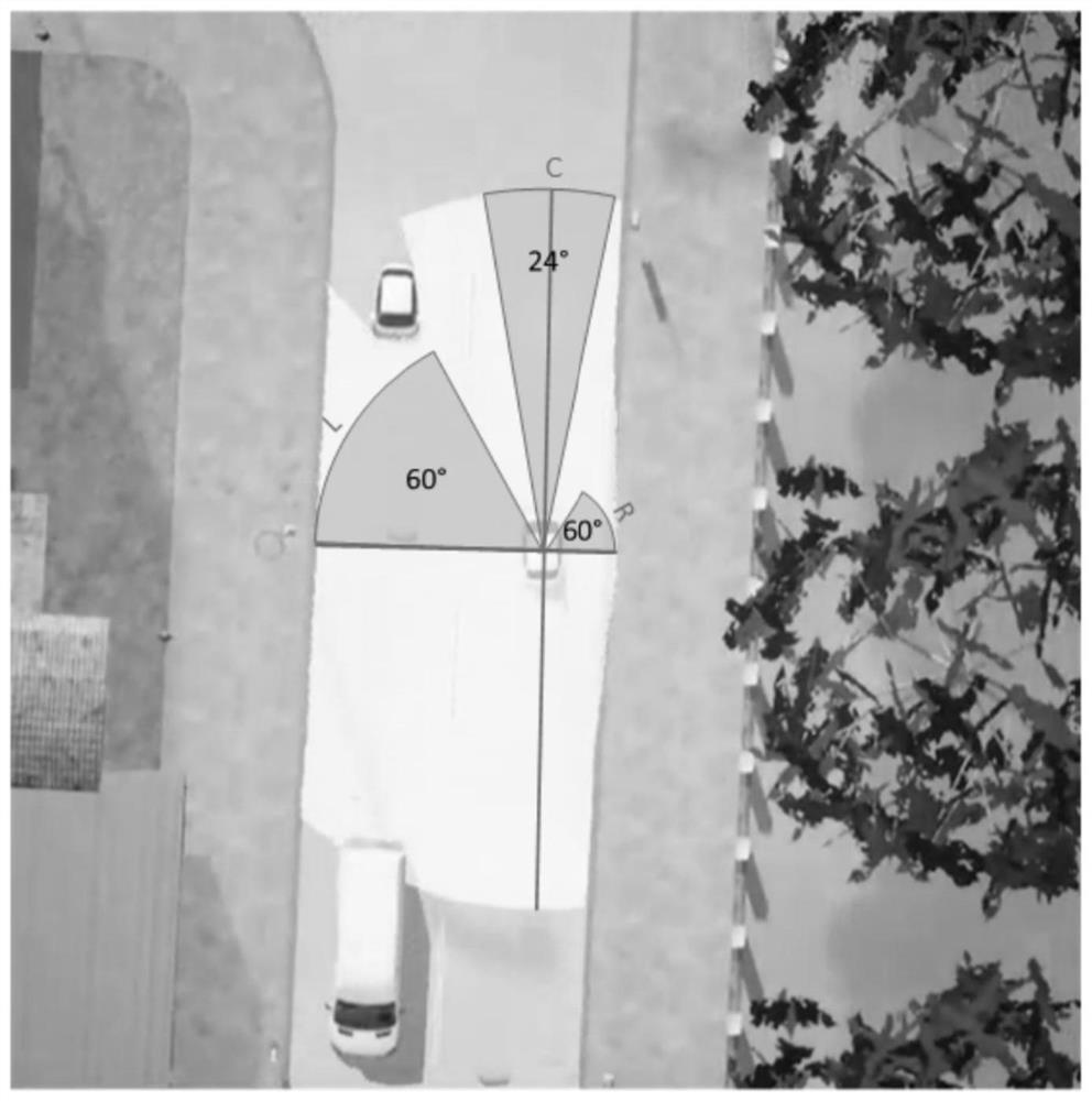
[0084] The planning control module is used to obtain the data in front of the robot and the data on the left and right sides respectively based on the normalized feasible area, and determine whether to enter the obstacle avoidance state bas...

Embodiment 3

[0087] In one or more embodiments, a terminal device is disclosed, including a server, the server includes a memory, a processor, and a computer program stored on the memory and operable on the processor, and the processor executes the The program realizes the robot navigation method based on multi-line laser radar in the first embodiment. For the sake of brevity, details are not repeated here.


PUM


Abstract

The invention discloses a robot navigation method and system based on a multi-line laser radar, and the method comprises the steps: obtaining point cloud data in a set area around a robot, and converting the point cloud data from a Cartesian coordinate system into a polar coordinate form; the high-dimensional feature and the visibility feature of each point cloud data are calculated respectively, and total features extracted through fusion are obtained; using U-Net as a basic framework to perform a segmentation task on the total feature to obtain a feasible region in a set region around the current robot; determining whether to enter an obstacle avoidance state based on the safety factor in front of the robot; in an obstacle avoidance state, determining an offset waypoint, and determining the speed and the rotation angle of the robot; and in a non-obstacle-avoidance state, the relative speed between the front obstacle and the robot is calculated, and the speed of the robot is dynamically adjusted. According to the invention, the robot can smoothly, safely and autonomously navigate in the real world, and the path planning and obstacle avoidance capabilities of the robot are greatly improved.

Description

technical field [0001] The invention relates to the technical field of robot navigation, in particular to a method and system for a robot navigation system based on multi-line laser radar. Background technique [0002] The statements in this section merely provide background information related to the present invention and do not necessarily constitute prior art. [0003] With the continuous development of science and technology, robot navigation is applied in all walks of life, such as industry, national defense, service industry and so on. In the unstructured scene, the automatic navigation of the robot still faces huge challenges. The automatic navigation system of the robot requires the robot to be able to sense the surrounding environment, follow the route to reach the final target point, and be able to deal with various static situations during driving. , Dynamic obstacles. [0004] In the field of autonomous driving, the mainstream sensors used for perception includ...

Claims


Application Information

Patent Timeline
Patent Type & Authority Applications(China)
IPC IPC(8): G01S17/89G01S17/93G01S17/931G01S7/483
CPCG01S17/89G01S17/93G01S17/931G01S7/483
Inventor 张伟陈伟谢世宽黄学钦宋然李贻斌
Owner SHANDONG UNIV
Why Eureka
Try Eureka