
Stereoscopic monitoring method for heavy metal pollution of water body by star-air-ground hyperspectral remote sensing

A hyperspectral remote sensing and heavy metal technology, applied in color/spectral characteristic measurement, measuring devices, material analysis through optical means, etc., to achieve the effects of wide monitoring area, reduced monitoring cost, and saving manpower and material resources

Pending Publication Date: 2022-04-22
广西壮族自治区地理信息测绘院
View PDF4 Cites 3 Cited by
  • Summary
  • Abstract
  • Description
  • Claims
  • Application Information

AI Technical Summary

Problems solved by technology

[0004] At present, there is no public literature report on high-precision water quality parameter inversion and heavy metal pollution monitoring research using the "spaceborne multispectral remote sensing + UAV hyperspectral + ground actual measurement" spectral stereoscopic monitoring technology at home and abroad.
There is no relevant patent registration for heavy metal pollution monitoring research and methods in China

Method used


Image

  • Stereoscopic monitoring method for heavy metal pollution of water body by star-air-ground hyperspectral remote sensing
  • Stereoscopic monitoring method for heavy metal pollution of water body by star-air-ground hyperspectral remote sensing
  • Stereoscopic monitoring method for heavy metal pollution of water body by star-air-ground hyperspectral remote sensing

Examples


specific Embodiment approach

[0053] It should be noted that the structures, proportions, sizes, etc. shown in this specification are only used to cooperate with the content disclosed in the specification for the understanding and reading of those familiar with this technology, and are not used to limit the conditions for the implementation of the present invention , any modification of structure, change of proportional relationship or adjustment of size shall still fall within the scope covered by the technical content disclosed in the present invention without affecting the effect and purpose of the present invention. .

[0054] At the same time, terms such as "upper", "lower", "left", "right", "middle" and "one" quoted in this specification are only for the convenience of description and are not used to limit this specification. The practicable scope of the invention and the change or adjustment of its relative relationship shall also be regarded as the practicable scope of the present invention without...

Embodiment 1

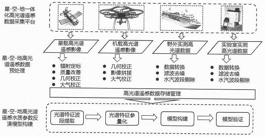
[0056] Such as figure 1 Shown, star-air-ground hyperspectral remote sensing water heavy metal pollution three-dimensional monitoring method, described method comprises:

[0057] Obtain original hyperspectral remote sensing images of polluted water areas;

[0058] Preprocessing the original hyperspectral remote sensing image to obtain an optimized hyperspectral remote sensing image of the target area;

[0059] Obtain water body samples from multiple sampling points in polluted water body areas, conduct laboratory tests on water body samples, and obtain multiple concentration data of heavy metal elements;

[0060] Acquire hyperspectral curves corresponding to each of the sampling points based on the optimized hyperspectral remote sensing image of the target area;

[0061] Preprocessing the hyperspectral curve to obtain an optimized hyperspectral curve;

[0062] The optimized hyperspectral curves include: multiple training sample hyperspectral curves and multiple verification ...

Embodiment 2

[0082] Spectral data acquisition, such as figure 2 Shown:

[0083] The equipment used for spectral data collection is ASDFieldSpec3 field portable spectrometer and its supporting equipment. FieldSpec3 portable ground object spectrometer is the latest product of ASD (Analytical Spectral Devices) in the United States. It is suitable for remote sensing measurement, crop monitoring, forest research and industrial All aspects of lighting surveying, oceanographic research and mineral exploration. Simple operation and powerful software package, this instrument can be used to measure radiance, CIE color, spectral reflectance and spectral transmittance.

[0084] (2) Water body data collection, such as image 3 shown.

[0085] A total of 36 sampling points were arranged to collect water body data, and the coordinates of each sampling point were recorded using Tianbao handheld GPS. Water samples shall be taken according to standard methods, and water quality parameters shall be test...


PUM


Abstract

The invention discloses a satellite-air-ground hyperspectral remote sensing water body heavy metal pollution three-dimensional monitoring method, which relies on a'satellite-air-ground 'hyperspectral remote sensing three-dimensional observation means, and discusses a technical principle and a technological process for monitoring water pollution by using hyperspectral data based on satellite and unmanned aerial vehicle hyperspectral remote sensing images and ground actual measurement data. In combination with the advantages of wide satellite hyperspectral image monitoring area, high unmanned aerial vehicle hyperspectral image acquisition speed and high sample point data heavy metal concentration extraction precision, target water area pollution condition information under different scales is acquired by means of qualitative evaluation and quantitative inversion, some existing technical difficulties are solved, and the target water area pollution condition information is obtained. Heavy metal content inversion estimation is carried out on heavy metal pollution in the water body of the water resource drainage basin, the change condition of heavy metal pollution is analyzed and monitored, water quality monitoring of the target water area is achieved, and a technical foundation is laid for environment protection and treatment work of the target water area.

Description

technical field [0001] The invention belongs to the technical field of water environment quantitative remote sensing, in particular to a three-dimensional monitoring method for heavy metal pollution in water by star-space-ground hyperspectral remote sensing based on a star-space-ground remote sensing observation network. Background technique [0002] The problem of water pollution is becoming more and more serious, especially the cadmium pollution incident in the Liujiang area of ​​Guangxi, which has had a great impact on the water safety of the local people. Therefore, the dynamic monitoring and evaluation of water pollution has become a top priority. However, the traditional water quality monitoring methods have complex detection and analysis processes and a long cycle. The frequency, timeliness and representativeness of data lag far behind the needs of environmental management and decision-making, especially Some sudden and large-scale environmental quality changes cannot...

Claims


Application Information

Patent Timeline
Patent Type & Authority Applications(China)
IPC IPC(8): G01N21/31G01N21/01
CPCG01N21/31G01N21/01
Inventor 张祖宇黄铭覃现郑志安黎胜周杨胡春龙覃智黄婷黄丽霞
Owner 广西壮族自治区地理信息测绘院
Learn More