River pollution source analysis and pollutant migration calculation method and system
A technology of pollutants and pollution sources, which is applied in the field of river water environment management, and can solve problems such as the impact of pollutants entering the river, river seepage, and river recharge, etc.
- Summary
- Abstract
- Description
- Claims
- Application Information
AI Technical Summary
Problems solved by technology
Method used
Image
Examples
Embodiment 1
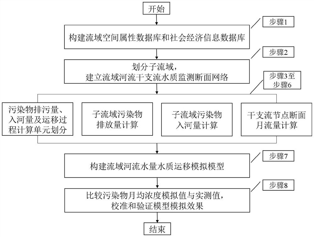
[0062] This embodiment provides a river pollution source analysis and pollutant migration calculation method, including the following steps:
[0063] Step 1. Construct the watershed spatial attribute database and socio-economic information database. The watershed spatial attribute database includes watershed topography, distribution of main and tributary water systems, land use data, soil types, meteorological data, hydrological stations and their runoff and water quality monitoring data, etc. The socio-economic information database includes watershed administrative divisions, planting structures, etc. , the distribution of pollutant discharge points such as area, population, industrial living, and breeding in each administrative region, as well as the statistical data of point source pollutants and non-point source pollutants in different industries such as industry, living, breeding, and planting.
[0064] Step 2, according to the spatial information of the watershed water s...
Embodiment 2
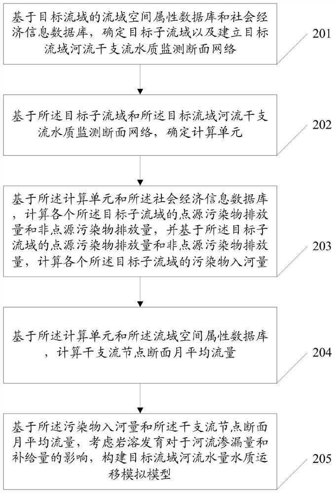
[0074] Such as figure 2 As shown, a river pollution source analysis and pollutant migration calculation method provided in this embodiment includes:
[0075] Step 201: Based on the watershed spatial attribute database and socio-economic information database of the target watershed, determine the target sub-basin and establish the water quality monitoring section network of the main and tributary rivers of the target watershed; the watershed spatial attribute database includes the topography and geomorphology information of the watershed, the distribution information of the main and tributary rivers , land use data, soil type, meteorological data, hydrological station location information, and the runoff information and water quality information collected by the hydrological station; the socio-economic information database includes the administrative area of the river basin, and the sewage discharge point corresponding to each administrative area of the river basin Distrib...
Embodiment 3
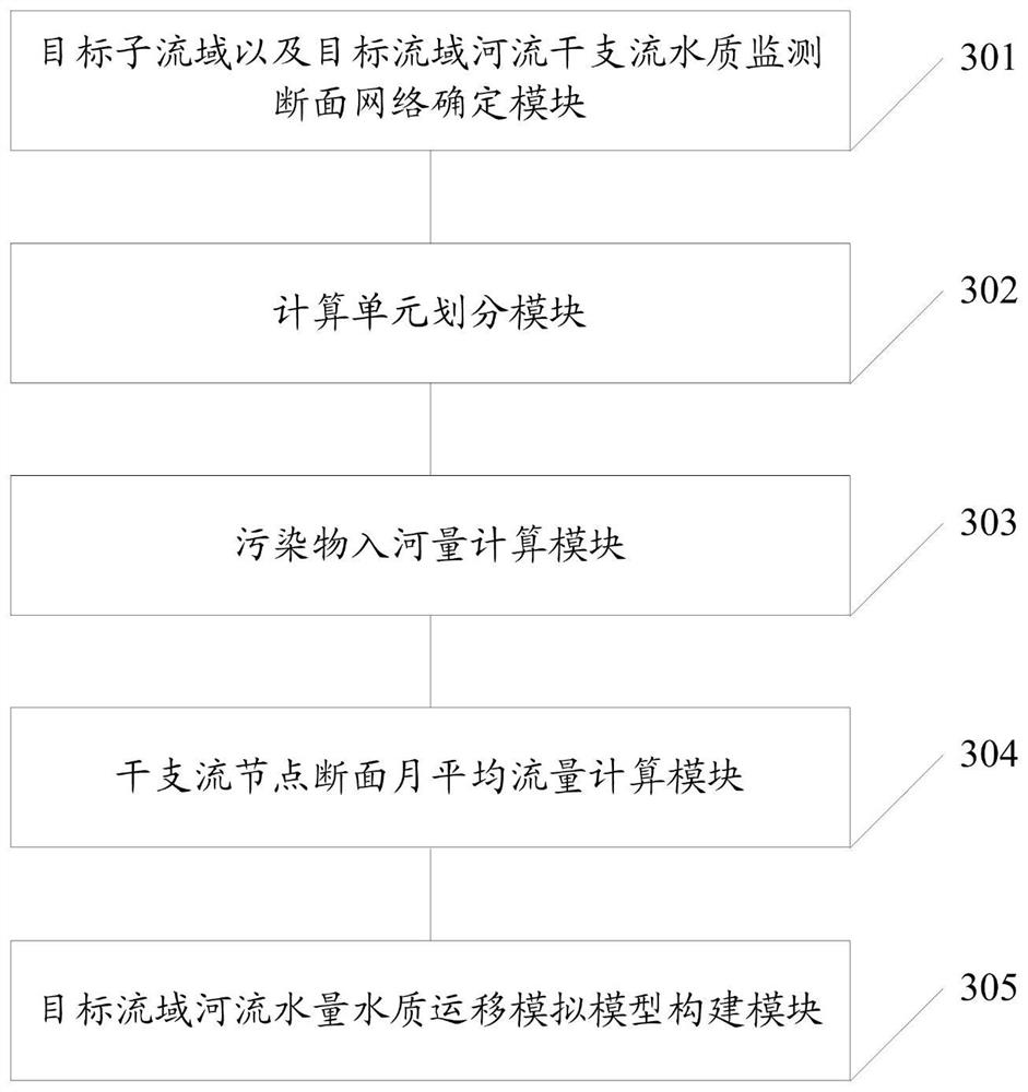
[0091] Such as image 3 As shown, a river pollution source analysis and pollutant migration calculation system provided in this embodiment includes:
[0092] The target sub-basin and the water quality monitoring section network determination module 301 of the main and tributary rivers of the target watershed are used to determine the target sub-basin and establish the water quality monitoring section network of the main and tributary rivers of the target watershed based on the watershed spatial attribute database and the socio-economic information database of the target watershed; The spatial attribute database of the watershed includes topographic and geomorphic information of the watershed, distribution information of main and tributary water systems, land use data, soil type, meteorological data, hydrological station location information, and runoff information and water quality information collected by the hydrological station; the socioeconomic information The database in...
PUM
 Abstract
Description
Claims
Application Information
 - R&D Engineer
- R&D Manager
- IP Professional
- Industry Leading Data Capabilities
- Powerful AI technology
- Patent DNA Extraction
Browse by: Latest US Patents, China's latest patents, Technical Efficacy Thesaurus, Application Domain, Technology Topic, Popular Technical Reports.
© 2024 PatSnap. All rights reserved.Legal|Privacy policy|Modern Slavery Act Transparency Statement|Sitemap|About US| Contact US: help@patsnap.com


