Landslide susceptibility improvement evaluation method based on InSAR and LR-IOE models

It is a technology of susceptibility and model, which is applied in the direction of radio wave reflection/re-radiation, complex mathematical operations, and utilization of re-radiation. It can solve the problems of not considering the dynamic change process of landslides, so as to avoid over-fitting problems and improve prediction accuracy. Enhanced effect

Active Publication Date: 2021-12-31
CHENGDU UNIVERSITY OF TECHNOLOGY
View PDF6 Cites 8 Cited by
  • Summary
  • Abstract
  • Description
  • Claims
  • Application Information

AI Technical Summary

Problems solved by technology

Traditional research generally uses factors such as geology and geography to build an evaluation index system, without considering that landslides are a dynamic process

Method used


Image

  • Landslide susceptibility improvement evaluation method based on InSAR and LR-IOE models
  • Landslide susceptibility improvement evaluation method based on InSAR and LR-IOE models
  • Landslide susceptibility improvement evaluation method based on InSAR and LR-IOE models

Examples


specific Embodiment

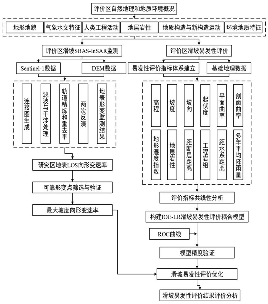
[0128] refer to figure 1 , the embodiments of the present invention provide a landslide susceptibility improvement evaluation method based on InSAR and entropy index-logistic regression coupling model, comprising the following steps:

[0129] S1: Collect and sort out multi-source data such as geology and geographical environment in the evaluation area, and select elevation, slope, aspect, profile curvature, relief, plane curvature, distance from fault, average annual precipitation, TWI index, distance from water system, stratum The 12 landslide disaster-causing factors such as lithology and engineering rock group are unified into the same projected coordinate system and spatial resolution. The evaluation area selected in this specific example is Huangzhong County, Xining City, Qinghai Province, China. There are a total of There are 147 historical landslide geological disaster points.

[0130] S102: According to the information list of existing landslide points in the evaluati...


PUM


Abstract

The invention discloses a landslide susceptibility improvement evaluation method based on InSAR and LR-IOE models, and the method comprises the following steps: S1, collecting the geological and geographic data of an evaluation region, extracting evaluation factors, and building a landslide susceptibility evaluation index system; S2, obtaining the deformation rate of the earth surface of the evaluation area in the radar sight line direction through the SBAS-InSAR technology, screening out reliable deformation points, and converting the deformation rate from the radar sight line direction to the maximum gradient direction to serve as a landslide susceptibility evaluation factor; and S3, constructing an entropy index-logistic regression coupling model, and performing landslide susceptibility evaluation. According to the method, the SBAS-InSAR technology is used for collecting deformation information of the long-time-sequence earth surface, the deformation rate in the maximum gradient direction serves as a landslide susceptibility evaluation factor, evaluation and optimization are conducted on the landslide susceptibility based on the entropy index-logistic regression coupling model, and the prediction precision of the model on the landslide susceptibility is remarkably improved.

Description

technical field [0001] The invention relates to the technical field of geological hazard evaluation, in particular to an improved evaluation method for landslide susceptibility based on InSAR and LR-IOE models. Background technique [0002] Due to the many mountainous areas in our country, the terrain is complex, the structure is developed, and geological hazards are widely distributed. Frequent geological disasters not only cause huge damage to the ecological environment, but also seriously threaten the life and property safety of local residents. The prevention and control of geological disasters is related to the security and development of human beings, and has become a major issue involving national security and social stability. It is of great significance to evaluate the susceptibility of landslide hazards and divide them to provide important basic data for the prevention and control of landslide geological hazards. [0003] Synthetic Aperture Radar (InSAR) is a new...

Claims


Application Information

Patent Timeline
IPC IPC(8): G01S13/90G06F17/16G06F17/18G06Q10/06G06Q50/26
CPCG01S13/9023G06F17/16G06F17/18G06Q10/06393G06Q50/26Y02A90/10
Inventor 邓辉张文江李雪聪薛东剑刘严松王战卫
Owner CHENGDU UNIVERSITY OF TECHNOLOGY
Why Eureka
Try Eureka