
Method and device for concurrently exporting regional remote sensing image from HBase tile storage

A technology of remote sensing images and regions, applied in the computer field, to achieve the effect of increasing speed

Pending Publication Date: 2021-10-12
GEOVIS CO LTD
View PDF0 Cites 0 Cited by
  • Summary
  • Abstract
  • Description
  • Claims
  • Application Information

AI Technical Summary

Problems solved by technology

[0004] The purpose of the present invention is to provide a method and device for concurrently exporting regional remote sensing images from HBase tile storage, to solve the problem of write blocking caused by writing data to the SQLite database, and to improve the speed of data import

Method used


Image

  • Method and device for concurrently exporting regional remote sensing image from HBase tile storage
  • Method and device for concurrently exporting regional remote sensing image from HBase tile storage
  • Method and device for concurrently exporting regional remote sensing image from HBase tile storage

Examples


Embodiment Construction

[0045] In order to understand the above-mentioned purpose, features and advantages of the present invention more clearly, the present invention will be further described in detail below in conjunction with the accompanying drawings and specific embodiments. It should be noted that, in the case of no conflict, the embodiments of the present application and the features in the embodiments can be combined with each other.

[0046] In the following description, many specific details are set forth in order to fully understand the present invention. However, the present invention can also be implemented in other ways different from those described here. Therefore, the protection scope of the present invention is not limited by the specific details disclosed below. EXAMPLE LIMITATIONS.

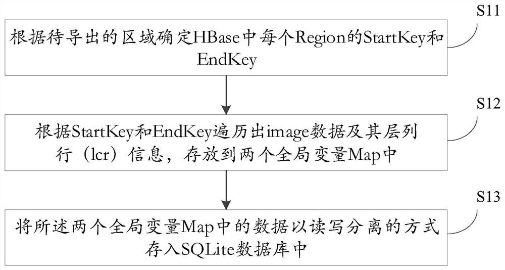
[0047] Such as figure 1 As shown, according to an embodiment of the present invention, a method for concurrently deriving regional remote sensing images from HBase tile storage is provided, includin...


PUM


Abstract

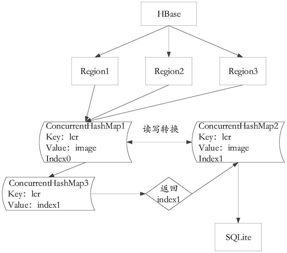
The invention provides a method and a device for concurrently exporting a regional remote sensing image from HBase tile storage. The exporting method comprises the following steps: determining a StartKey and an EndKey of each Region in an HBase according to a region to be exported; traversing image data and layer column row (lcr) information of the image data according to the StartKey and the EndKey, and storing the image data and the layer column row (lcr) information of the image data into two global variables Map; and storing the data in the two global variables Map into an SQLite database in a read-write separation manner. Through the design mode of List array + Map set, read-write separation is realized, the blocking problem generated when the data is written into the SQLite database is solved, and the data importing speed is increased.

Description

technical field [0001] The invention relates to the field of computer technology, in particular to a method and device for storing and deriving regional remote sensing images from HBase tiles. Background technique [0002] Currently, most file systems and transfer protocols are not very efficient for exporting millions of map tiles, whether you are processing millions of tiles data efficiently via USB or network copying Both are very low. [0003] The general way to read tile data is to access SQLite through GeoWebCache, because SQLite provides a specification that allows millions of tile data to be stored in a file, so storing tile data through SQLite is relatively The ideal way, but how to write the tile data in HBase into SQLite is a big problem. The usual way is to use the built-in method of GeoWebCache, but it takes about 5 years to export the global map in this way. Contents of the invention [0004] The purpose of the present invention is to provide a method and d...

Claims


Application Information

Patent Timeline
Patent Type & Authority Applications(China)
IPC IPC(8): G06F16/29G06F16/22G06F16/23G06F16/2453
CPCG06F16/29G06F16/2282G06F16/2308G06F16/24532
Inventor 王晓东张家旺赵文波张敬亮杨光辉傅伟康马银龙毕俊
Owner GEOVIS CO LTD
Learn More