Eureka AIR delivers breakthrough ideas for toughest innovation challenges, trusted by R&D personnel around the world.

Three-dimensional reconstruction error active correction method based on unmanned aerial vehicle

A 3D reconstruction and drone technology, applied in 3D modeling, computer parts, image data processing, etc., can solve problems such as field of view errors, lack of monitoring, and standards affecting key frame selection.

Active Publication Date: 2021-09-24
NANKAI UNIV
View PDF6 Cites 2 Cited by
  • Summary
  • Abstract
  • Description
  • Claims
  • Application Information

AI Technical Summary

Problems solved by technology

However, most studies did not analyze the characteristics of various constraints and the specific degree of realization
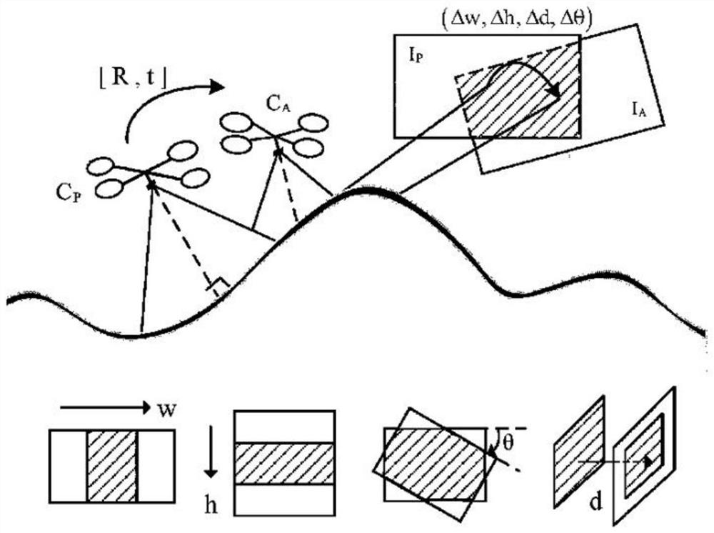
Especially in the process of 3D reconstruction image acquisition under the guidance of active vision, the actual field of view error of the image captured by tracking the planned trajectory under the constraints of photography geometry is not well monitored, which affects the selection of key frames

Method used


Image

  • Three-dimensional reconstruction error active correction method based on unmanned aerial vehicle
  • Three-dimensional reconstruction error active correction method based on unmanned aerial vehicle
  • Three-dimensional reconstruction error active correction method based on unmanned aerial vehicle

Examples


Embodiment

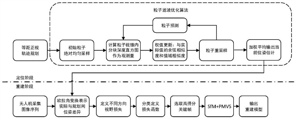
[0044] In order to verify the effectiveness of the method, in the virtual simulation platform environment, the 3D reconstruction experiment under the positioning of the flying camera, the evaluation of the image field of view loss and the reselection of the key frame is carried out, and the 3D static region of interest can be obtained from the commercial satellite data artificially. The digital elevation model (DEM) of the aircraft is represented in the form of point cloud, and the flight trajectory planned in the previous stage is obtained based on the shooting constraints of the equidistant orthographic view.

[0045] Example:

[0046] Such as figure 1 , 2 As shown, this embodiment will check the effectiveness of the method based on the process, including the following specific steps:

[0047] Step 1: Use the equidistant orthographic constraint to plan the shooting trajectory of the UAV to achieve the desired 3D reconstruction optimization effect;

[0048] Step 2: Positio...


PUM


Abstract

The invention provides a three-dimensional reconstruction error active correction method based on an unmanned aerial vehicle, and the method comprises the following steps: planning a shooting track of the unmanned aerial vehicle through employing an equidistant front view constraint, so as to achieve an expected three-dimensional reconstruction optimization effect; positioning the airborne camera of the unmanned aerial vehicle through an improved particle filter positioning algorithm based on a block depth histogram; designing a group of quantitative indexes to evaluate the image view loss caused by the error between the actual flight and the expected planning pose; and selecting a key frame from the image acquired by the unmanned aerial vehicle to participate in reconstruction according to the view overlapping rate and the loss function score. According to the method, the reconstruction track of the unmanned aerial vehicle is planned by adopting the equidistant front view constraint, a particle filtering optimization method based on depth block histogram analysis is provided to accurately position the unmanned aerial vehicle, and a group of quantitative indexes is further designed to evaluate the expected view loss of the image caused by the pose error, and the key frames participating in the three-dimensional reconstruction are reselected, so that the visual reconstruction effect is enhanced.

Description

technical field [0001] The invention belongs to the field of three-dimensional reconstruction of unmanned aerial vehicles, and in particular relates to an active correction method for three-dimensional reconstruction errors based on unmanned aerial vehicles. Background technique [0002] Performing a complete visual overlay mission aims to reconstruct a complex 3D field environment and achieve dynamic updates. The final rendering result is a textured 3D surface model. UAV platforms equipped with vision equipment can perform effective long-term area surveillance and simultaneously Perform various wide-area tasks, such as terrain reconstruction, scene dynamic update, target search and tracking, etc. [0003] However, there are many challenges in the task of UAV visual coverage under complex terrain. For example, due to uncertain errors such as noise and body shaking in the trajectory tracking process, it is impossible to completely maintain the planned trajectory under the co...

Claims


Application Information

Patent Timeline
IPC IPC(8): G06T17/00G06T7/73G06T5/40G06T5/00G06K9/62
CPCG06T17/00G06T7/73G06T5/40G06T2207/10028G06F18/22G06T5/70Y02T10/40
Inventor 王鸿鹏李耀晶
Owner NANKAI UNIV
Why Eureka
Eureka Blog
Learn More