Spatial scale selection method and device for mass-occurring landslide
A space-scale, cluster-like technology, applied in structured data retrieval, resources, instruments, etc., can solve problems such as lack of scale selection method, difficulty in positioning and dividing natural slope units, and failure to consider the impact of landslide natural slope unit division.
- Summary
- Abstract
- Description
- Claims
- Application Information
AI Technical Summary
Problems solved by technology
Method used
Image
Examples
Embodiment Construction
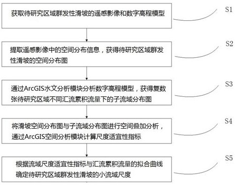
[0059] see figure 1 , which is a flowchart of a spatial scale selection method for mass landslides according to an embodiment of the present invention.
[0060] A method for selecting spatial scales of mass landslides according to the present invention includes:
[0061] S1 Obtain remote sensing images and digital elevation models of mass landslides in the area to be studied;
[0062] S2 extracts the spatial distribution information in the remote sensing image, and obtains the spatial distribution map of mass landslides in the area to be studied;
[0063] S3 analyzes the digital elevation model through the ArcGIS spatial analysis module, and obtains a plurality of sub-basin distribution maps under different confluence accumulation flows in the area to be studied;
[0064] S4 performs spatial overlay analysis on the sub-basin distribution map and the landslide spatial distribution map, and calculates the watershed-scale suitability index through the ArcGIS spatial analysis mo...
PUM
 Abstract
Description
Claims
Application Information
 - R&D
- Intellectual Property
- Life Sciences
- Materials
- Tech Scout
- Unparalleled Data Quality
- Higher Quality Content
- 60% Fewer Hallucinations
Browse by: Latest US Patents, China's latest patents, Technical Efficacy Thesaurus, Application Domain, Technology Topic, Popular Technical Reports.
© 2025 PatSnap. All rights reserved.Legal|Privacy policy|Modern Slavery Act Transparency Statement|Sitemap|About US| Contact US: help@patsnap.com


