A climate data inversion method and system based on fusion of multi-source GNSS occultation data

A technology of data inversion and data fusion, applied in climate sustainability, geographic information database, structured data retrieval, etc., to improve efficiency and avoid systematic deviation

Active Publication Date: 2021-12-07
NAT SPACE SCI CENT CAS
View PDF16 Cites 0 Cited by
  • Summary
  • Abstract
  • Description
  • Claims
  • Application Information

AI Technical Summary

Problems solved by technology

However, currently there is no Beidou occultation climate dataset, and the GNSS occultation climate analysis is only based on GPS occultation observations

Method used


Image

  • A climate data inversion method and system based on fusion of multi-source GNSS occultation data
  • A climate data inversion method and system based on fusion of multi-source GNSS occultation data
  • A climate data inversion method and system based on fusion of multi-source GNSS occultation data

Examples


Embodiment Construction

[0061] The technical solution of the present invention will be described in detail below in conjunction with the accompanying drawings.

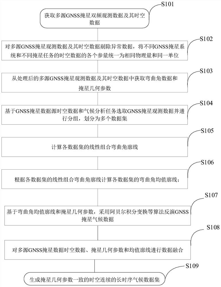
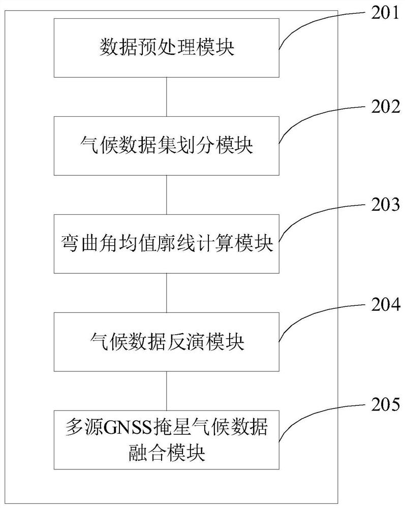
[0062] Such as figure 1 As shown, Embodiment 1 of the present invention provides a climate data inversion method based on multi-source GNSS occultation data fusion, including:

[0063] Step S101) Obtain multi-source GNSS occultation observation data and its space-time data;

[0064] GNSS occultation observation data include: dual-frequency curved angle profile, position and time of GNSS satellites, and position and time of LEO satellites; spatio-temporal data include: universal time of occultation events and longitude and latitude of occultation event positions;

[0065] Multiple sources refer to different GNSS occultation systems as well as different GNSS occultation missions.

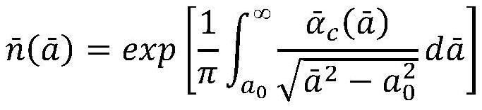
[0066] Step S102) Eliminate abnormal data from the multi-source GNSS occultation observation data and its spatio-temporal data, and unify each parameter of the sp...


PUM


Abstract

The invention discloses a climate data inversion method and system based on the fusion of multi-source GNSS occultation data, comprising: acquiring multi-source GNSS occultation observation data and its time-space data; multi-source GNSS occultation observation data and its time-space data Perform preprocessing; obtain bending angle data and occultation geometric parameters from the preprocessed data; occultation geometric parameters include: curvature radius of occultation tangent point, geoid gap and influence parameters; based on GNSS occultation data source space-time Data and climate analysis tasks select GNSS occultation observation data and group them into multiple data sets; calculate the mean bending angle profile based on the bending angle data and occultation geometric parameters of each data set; calculate the mean bending angle profile based on the mean bending angle profile and occultation Star geometric parameters, using Abelian integral transformation to invert multi-source GNSS occultation climate data; according to multi-source GNSS occultation data space-time data, occultation geometric parameters and GNSS occultation climate data, the generated time, space and occultation geometric parameters are consistent GNSS occultation long-time climate data.

Description

technical field [0001] The invention relates to the field of atmospheric remote sensing and its meteorological and climate applications, in particular to a climate data inversion method and system based on fusion of multi-source GNSS occultation data. Background technique [0002] Global climate change is closely related to human development. Climate monitoring is one of the scientific and technological challenges that people face. The surge in meteorological satellite observation data has promoted the development of satellite climatology. However, the "drift" of atmospheric observation data from different satellites and different detectors A major problem of learning. GNSS occultation detection technology has the advantages of high vertical resolution, self-calibration and long-term stability, and has the potential to provide reference climate data sets. [0003] The research shows that the quality of GPS occultation data of different occultation missions has a good consis...

Claims


Application Information

Patent Timeline
Patent Type & Authority Patents(China)
IPC IPC(8): G06F16/2458G06F16/29G06F17/18
CPCG06F17/18G06F16/2462G06F16/2474G06F16/29Y02A90/10
Inventor 柳聪亮孙越强杜起飞白伟华王先毅胡鹏谭广远蔡跃荣夏俊明王冬伟李伟吴春俊刘成尹聪李福乔颢
Owner NAT SPACE SCI CENT CAS
Why Eureka
Try Eureka