Partition interpolation processing method and device for lake terrain simulation

An interpolation processing and lake technology, applied in the field of lake management, can solve the problems of the final formation of terrain data and the large undulation of the lake bottom, and achieve the effect of accurate terrain conditions, reducing model errors, and easy to popularize and use.

Active Publication Date: 2021-07-20
YANGZHOU UNIV
View PDF5 Cites 2 Cited by
  • Summary
  • Abstract
  • Description
  • Claims
  • Application Information

AI Technical Summary

Problems solved by technology

This leads to a large undulation of the lake bottom, and different power values ​​will have a greater impact on the final formation of terrain data

Method used


Image

  • Partition interpolation processing method and device for lake terrain simulation
  • Partition interpolation processing method and device for lake terrain simulation
  • Partition interpolation processing method and device for lake terrain simulation

Examples


Embodiment Construction

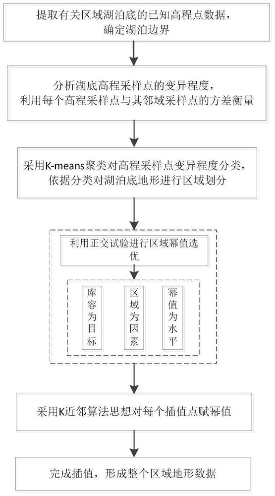
[0034] Below in conjunction with accompanying drawing and actual elevation sampling point data of Taihu Lake, the present invention will be further described.

[0035] Such as figure 1 As shown, a kind of partition interpolation processing method for lake terrain simulation disclosed in the embodiment of the present invention mainly includes the following steps:

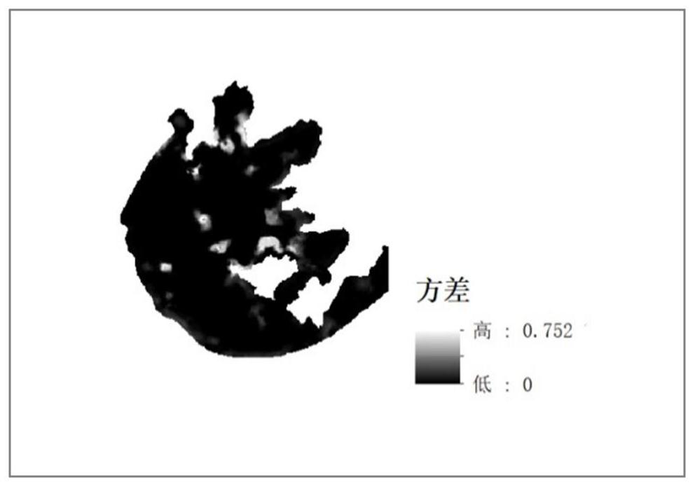
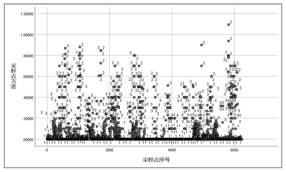
[0036] (1) Extract the known elevation point data of the lake bottom and accurate lake boundary data. In this example, the elevation point data of Taihu Lake are firstly obtained from the measured data, and a total of 6242 elevation point data are extracted, and the elevation is roughly distributed in the range of -3 to -1.5m. The individual elevation mutations in the data are relatively large, which are considered as unreasonable data processing and eliminated.

[0037] (2) Select the variance as an index to measure the fluctuation degree of the elevation sampling point data at the bottom of the lake, use K-means ...


PUM


Abstract

The invention discloses a partition interpolation processing method and device for lake terrain simulation. The method comprises the following steps: firstly, extracting known elevation point data of a lake bottom and lake boundary data; secondly, processing the variance of the fluctuation degree of the elevation sampling points by adopting K-means clustering, carrying out regional division on the lakebed according to a clustering result, and respectively endowing power values for the elevation variation degrees of different regions; then determining the range of the power value of each region and the discrete step length of the power value, constructing an orthogonal test table to carry out a combination test of the power value of each region, and measuring the advantages and disadvantages of the power value combination by taking a lake elevation-storage capacity curve as a target; and finally, according to the optimal region power value combination, determining the number and coordinates of to-be-interpolated points at the lakebed by utilizing grid division, and achieving regional interpolation of an inverse distance weighted interpolation method by referring to the idea of a K-nearest neighbor algorithm. The power value of each region is analyzed and determined by using objective measurement data, the regional terrain is accurately interpolated, and the method and device are easy to popularize and use in lake terrain simulation.

Description

technical field [0001] The invention relates to a partition interpolation processing method and device for lake terrain simulation, belonging to the field of lake management. Background technique [0002] Most of the lakes in my country are shallow lakes and most of them are naturally formed, and the bottom of the lake has a large undulation, and the topography of the bottom of the lake is a prerequisite for the study of lakes. In the research of lake hydrodynamic model, the elevation points of part of the lake bottom are generally determined, and then the terrain data is formed by interpolation method. At present, inverse distance weighted interpolation is the mainstream method of lake terrain interpolation, and its specific formula is Z(x,y)=w i Z * (x i ,y i ),in is the length weight of each known elevation point, is the distance between discrete known elevation points and interpolation points, Z * (x i ,y i ) is the weighted average of known elevation points, ...

Claims


Application Information

Patent Timeline
Patent Type & Authority Applications(China)
IPC IPC(8): G06F30/27G06F30/28
CPCG06F30/27G06F30/28Y02A90/30
Inventor 陈再扬龚懿汪靓程吉林卓灵朱博文张培杰
Owner YANGZHOU UNIV
Why Eureka
Try Eureka