
An urban land use function recognition method based on remote sensing images and point of interest data

A technology of urban functions and identification methods, applied in neural learning methods, character and pattern recognition, instruments, etc., can solve problems such as people's activities and behaviors that do not consider the spatial relationship between ground objects and objects, and improve the model similarity discrimination ability and strong adaptability. , the effect of avoiding the bias and inefficiency problems of artificially selected features

Active Publication Date: 2022-04-05
SICHUAN UNIV
View PDF6 Cites 0 Cited by
  • Summary
  • Abstract
  • Description
  • Claims
  • Application Information

AI Technical Summary

Problems solved by technology

However, methods based on remote sensing data can only extract low-level semantic features in urban functional areas, without considering the spatial relationship of objects and crowd activities.

Method used


Image

  • An urban land use function recognition method based on remote sensing images and point of interest data
  • An urban land use function recognition method based on remote sensing images and point of interest data

Examples


Embodiment Construction

[0025] Below in conjunction with accompanying drawing and embodiment the present invention is described in further detail, it is necessary to point out that following embodiment is only used for further description of the present invention, can not be interpreted as the restriction to protection scope of the present invention, those skilled in the art According to the content of the invention above, making some non-essential improvements and adjustments to the present invention for specific implementation shall still belong to the protection scope of the present invention.

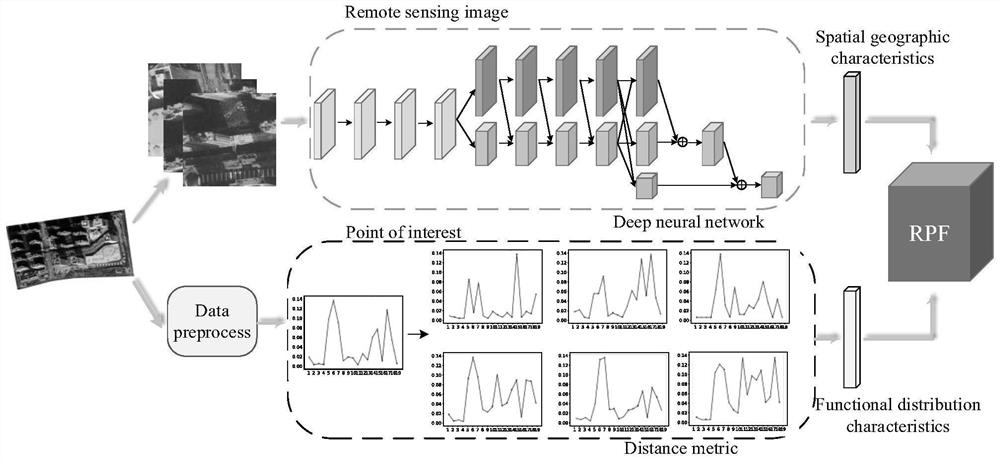
[0026] The urban land use function recognition method based on remote sensing images and POI data includes the following steps:

[0027] (1) Obtain the remote sensing image data and point-of-interest (POI) data of the functional area of ​​the city to be studied through the interface of Google Earth and Baidu Map;

[0028] (2) Divide the remote sensing image data into training set and test set by 8:2, build...


PUM


Abstract

The invention proposes an urban land use function recognition method based on remote sensing pictures and interest point data. The previous identification methods of urban functional areas only aimed at a single remote sensing image data or social perception data, ignoring the overall functional attribute information of urban areas to a certain extent. To solve this problem, a multimodal urban land use function identification framework is proposed. The methods include: constructing a deep multi-channel residual neural network for urban remote sensing image recognition, and exploring spatial and geographical features in remote sensing images. Second, the frequency-functional density of the distribution of interest points in different functional areas of the city is studied, and the functional distribution features of urban areas are extracted based on metric learning. Finally, two features of different dimensions are fused in the heterogeneous feature fusion module to further improve the performance of urban land use function recognition. Experiments prove that this method has good practicability and can be widely used in the identification of urban functional areas.

Description

technical field [0001] The invention relates to the problem of image and text data recognition in the field of deep learning, in particular to a method for recognizing functions of urban land based on remote sensing pictures and point-of-interest data. Background technique [0002] In recent years, the urbanization of countries in the world has developed rapidly. As an important part of urbanization, land use and land cover play an extremely important role in environmental protection, infrastructure construction and urban planning. Due to the development of urbanization and the impact of human activities, different urban areas often have complex urban land functions, such as commercial areas, residential areas, and industrial areas. The function and scope of an urban area not only depends on the government's planning and deployment, but also depends on people's actual way of life. The actual geographical distribution of urban functional areas is of great significance for s...

Claims


Application Information

Patent Timeline
Patent Type & Authority Patents(China)
IPC IPC(8): G06V20/10G06V10/25G06V10/80G06K9/62G06N3/04G06N3/08
CPCG06N3/08G06V20/176G06V10/25G06N3/045G06F18/253
Inventor 卿粼波许盛宇何小海滕奇志刘美牛通
Owner SICHUAN UNIV
Learn More