Land utilization change and carbon reserve quantitative estimation method based on remote sensing data
A technology of remote sensing data and land, applied in the field of remote sensing, can solve problems such as variable collinearity
- Summary
- Abstract
- Description
- Claims
- Application Information
AI Technical Summary
Problems solved by technology
Method used
Image
Examples
Embodiment Construction
[0025] The present invention will be further described in detail below in conjunction with the accompanying drawings and specific embodiments.
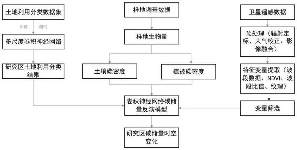
[0026] Such as figure 1 The shown method for quantitative estimation of land use change and carbon storage based on remote sensing data includes the following steps:
[0027] Step 1. Image download: According to the research needs, download the remote sensing images of the designated research area over the years. Obtain the labeled land classification dataset;
[0028] Step 2. Image preprocessing: perform preprocessing operations such as geometric correction, mosaicking, cropping, radiometric calibration, and atmospheric correction on remote sensing images;
[0029] Geometric correction: the process of using a series of mathematical models to correct and eliminate geometric errors in remote sensing images.
[0030] Radiometric Calibration: Converts the value or voltage recorded by the sensor to absolute radiance.
[0031] Atmosphe...
PUM
 Abstract
Description
Claims
Application Information
 - R&D
- Intellectual Property
- Life Sciences
- Materials
- Tech Scout
- Unparalleled Data Quality
- Higher Quality Content
- 60% Fewer Hallucinations
Browse by: Latest US Patents, China's latest patents, Technical Efficacy Thesaurus, Application Domain, Technology Topic, Popular Technical Reports.
© 2025 PatSnap. All rights reserved.Legal|Privacy policy|Modern Slavery Act Transparency Statement|Sitemap|About US| Contact US: help@patsnap.com


