
Laser Doppler velocimeter-based initial alignment method of inertial navigation system during advancing

A Doppler velocimeter and initial alignment technology, applied in the field of integrated navigation, can solve the problems of deviation of measurement results, low measurement accuracy, uncontrollability of height, etc., and achieve the effect of improving accuracy and estimation accuracy

Active Publication Date: 2021-05-14
NAT UNIV OF DEFENSE TECH
View PDF6 Cites 4 Cited by
  • Summary
  • Abstract
  • Description
  • Claims
  • Application Information

AI Technical Summary

Problems solved by technology

[0003] At this stage, it is most common to use GPS to provide accurate speed and position information for initial alignment during travel, but the use of GPS has the following disadvantages: (1) The GPS signal is unstable, the GPS receiver has poor anti-interference ability, and the GPS signal is easily damaged by tall buildings. (2) GPS is the second-generation satellite navigation system developed by the United States. It is a non-autonomous system and is highly uncontrollable.
Although my country's Beidou satellite navigation system has been networked, it is also non-autonomous
In addition, the odometer can also provide speed and mileage information for the vehicle. The initial alignment between the journeys assisted by the odometer has the characteristics of being completely autonomous, so it is widely used, because the measurement result of the odometer is related to the wheel circumference of the vehicle, and The circumference of the wheel is affected by the temperature, pressure and wear of the wheel, so the measurement accuracy is low. In addition, the slipping and jumping of the wheel will also cause large deviations in the measurement results of the odometer

Method used


Image

  • Laser Doppler velocimeter-based initial alignment method of inertial navigation system during advancing
  • Laser Doppler velocimeter-based initial alignment method of inertial navigation system during advancing
  • Laser Doppler velocimeter-based initial alignment method of inertial navigation system during advancing

Examples


Embodiment Construction

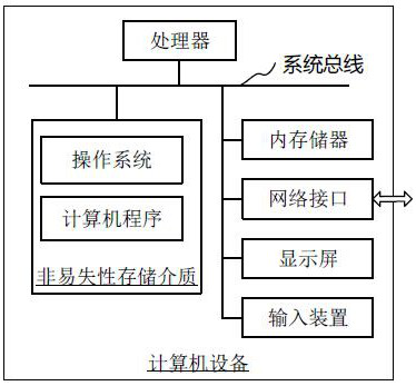
[0060] In order to make the purpose, technical solution and advantages of the present application clearer, the present application will be further described in detail below in conjunction with the accompanying drawings and embodiments. It should be understood that the specific embodiments described here are only used to explain the present application, and are not intended to limit the present application.

[0061] When the strapdown inertial navigation system is in use, the laser Doppler speedometer is installed at a suitable position on the vehicle, so that the light spot of the speedometer can effectively hit the ground and output the speed information of the vehicle in real time. After the initial calibration of the inertial measurement unit, the zero bias, installation error angle and scale coefficient error of the gyroscope and accelerometer are obtained, and the inertial measurement unit is installed in the center of the rear wheel axle of the vehicle. After the initial...


PUM


Abstract

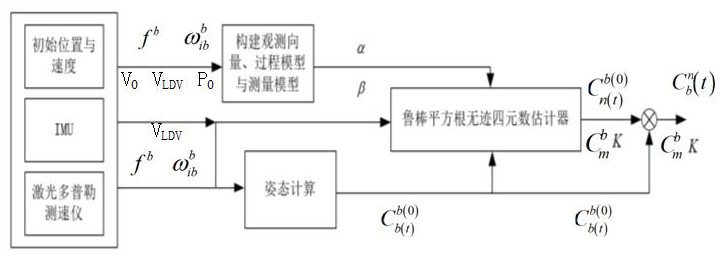
The invention relates to a laser Doppler velocimeter-based initial alignment method of an inertial navigation system during advancing. The method comprises the following steps: under a geocentric inertial coordinate system and a local navigation coordinate system, establishing a process model and a measurement model of the alignment process of the strapdown inertial navigation system based on a speed measurement value, a specific force equation and attitude direction cosine matrix estimation of the laser Doppler velocimeter; constructing a state vector by taking an attitude error of inertial navigation equipment, zero offset drift of a gyroscope, zero offset drift of an accelerometer, and a mounting angle error and a scale coefficient error of a laser Doppler velocimeter as components, establishing a robust square root unscented quaternion estimator, and obtaining a predicted value of the state vector to carry out initial alignment between marches on the strapdown inertial navigation system. The process model and the measurement model of the method utilize the high-precision speed output of the laser Doppler velocimeter, and the error of the inertial measurement unit and the installation inclination angle and the scale coefficient of the laser Doppler velocimeter are considered in initial alignment, so that the attitude estimation precision can be improved.

Description

technical field [0001] The present application relates to the technical field of integrated navigation, in particular to a laser Doppler velocimeter-based initial alignment method for an inertial navigation system during travel. Background technique [0002] In the whole navigation process, the level of initial alignment accuracy is directly related to the performance of inertial navigation. The existing alignment methods include transfer alignment, static base alignment, and on-the-fly alignment. Transfer alignment requires high-precision inertial navigation as a reference, which is generally used for large ships or some special applications. Static base alignment is a commonly used alignment method for high-precision inertial navigation, which requires the carrier to remain stationary during the alignment process. This makes the alignment of the static base have high precision, but limits the mobility of the carrier and cannot be carried out as needed. On-the-fly alignm...

Claims


Application Information

Patent Timeline
IPC IPC(8): G01C25/00
CPCG01C25/005
Inventor 向志毅周健王琦聂晓明席崇宾黄荣陈兰剑程吉利
Owner NAT UNIV OF DEFENSE TECH
Learn More