
Satellite earth shadow autonomous forecasting method and system based on sun sensor

A sun sensor and forecasting system technology, which is applied in the field of on-satellite earth shadow forecasting, can solve problems such as inapplicable on-satellite autonomous calculation and complex algorithms, and achieve the benefits of on-satellite autonomous planning, simplified calculation, and earth-shadow discriminant simple effect

Active Publication Date: 2021-04-09
SHANGHAI SATELLITE ENG INST
View PDF4 Cites 6 Cited by
  • Summary
  • Abstract
  • Description
  • Claims
  • Application Information

AI Technical Summary

Problems solved by technology

However, the algorithm is relatively complex and not suitable for autonomous calculations on stars

Method used


Image

  • Satellite earth shadow autonomous forecasting method and system based on sun sensor
  • Satellite earth shadow autonomous forecasting method and system based on sun sensor
  • Satellite earth shadow autonomous forecasting method and system based on sun sensor

Examples


Embodiment 1

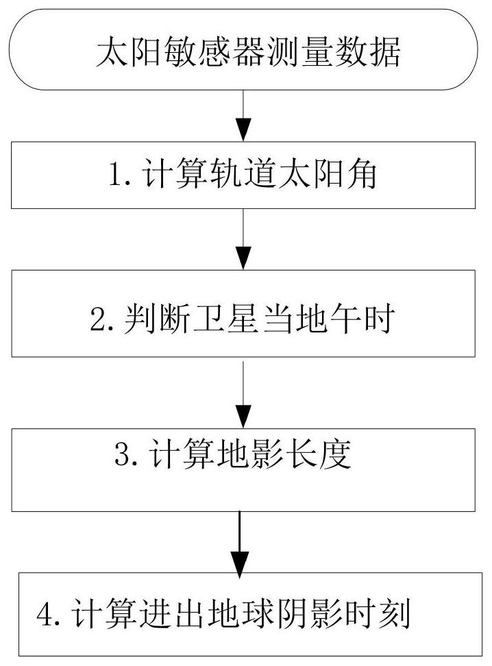
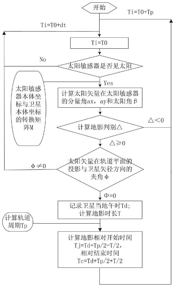
[0057] According to a kind of satellite earth shadow self-prediction method based on sun sensor provided by the present invention, such as Figure 1 to Figure 9 shown, including:

[0058] Step M1: Calculate the current sun angle by using the sun sensor measurement data installed on the satellite body;

[0059] Step M2: Calculate and judge the current noon time of the satellite by using the measurement data of the sun sensor;

[0060] Step M3: Calculate the value of the earth shadow discriminant by using the sun angle and the satellite vector or orbital height to determine whether the satellite has an earth shadow, and when there is an earth shadow, calculate the earth shadow duration;

[0061] Step M4: Calculate the moment of entering and exiting the earth's shadow by using the orbital altitude of the satellite and the current noon of the satellite.

[0062] Specifically, the step M1 includes: calculating the sun angle β by using the sun sensor measurement information and th...

Embodiment 2

[0090] Embodiment 2 is a modification of embodiment 1

[0091] The invention is suitable for circular orbit satellites, and uses the measurement information of the sun sensor installed under the satellite body to quickly judge whether there is an earth shadow in one orbit, and if so, calculate the time when the spacecraft enters and exits the shadow. This method is simple to calculate and easy to operate and implement. This calculation method is suitable for satellite autonomous mission planning.

[0092] A preferred embodiment of the present invention utilizes the sun sensor to carry out the circular orbit earth shadow forecasting method, comprises the following steps:

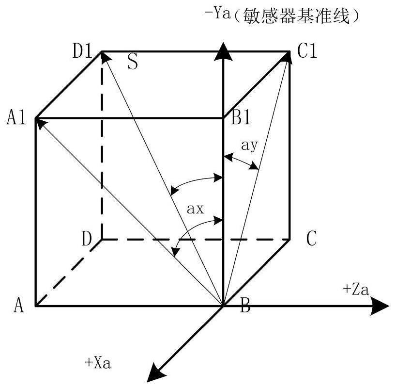
[0093] Step (1) utilizes the measurement data of solar sensor, calculates solar angle β;

[0094] The sun sensor is an important satellite attitude measurement component, which is used for satellite attitude determination and attitude control, and is usually installed on the -Zs axis and ±Xs axis of the sat...


PUM


Abstract

The invention provides a sun sensor-based satellite earth shadow autonomous forecasting method and system. The method comprises the steps: M1, calculating a current sun angle by using sun sensor measurement data installed on a satellite body; M2, calculating and judging the current noon time of the satellite by utilizing the measured data of the sun sensor; M3, calculating the value of a geography discriminant by using the sun angle and the sagittal path or orbit height of the satellite, determining whether the satellite has a geography or not, and calculating the geography duration when the geography exists; M4, calculating the earth shadow entering and exiting moment by utilizing the satellite orbit height and the current noon time of the satellite. On-satellite autonomous earth shadow management is carried out by using sun sensor measurement information installed on a satellite body, orbit parameters do not need to be injected on the ground, and dependence on ground operation is low.

Description

technical field [0001] The present invention relates to the technical field of on-satellite earth shadow forecasting, and belongs to on-satellite autonomous management. Specifically, it relates to a method and system for autonomous satellite earth shadow forecasting based on a sun sensor. The sensor measures the information, and judges whether there is an earth shadow in one orbit through the geometric relationship between the sun and the orbit plane. If there is, the method of predicting the time when the satellite enters and exits the earth shadow provides timing information for the autonomous management of the earth shadow on the satellite. Background technique [0002] The management of the shadow on the planet is one of the important contents in the autonomous management of the spacecraft. During the Earth's shadow period, the temperature of the entire star of the spacecraft drops, and the sun sensor cannot be sensitive to the sun, and the solar panels cannot track the ...

Claims


Application Information

Patent Timeline
IPC IPC(8): G06F30/20G06Q10/04G06F119/12
CPCG06F30/20G06Q10/04G06F2119/12
Inventor 李绿萍张伟边志强信思博赵训友李鉴孙英梅
Owner SHANGHAI SATELLITE ENG INST
Learn More