
Autonomous controllable three-dimensional natural resource one-graph system construction method

A technology of natural resources and construction methods, applied in the field of self-controllable three-dimensional natural resources one-map system construction, can solve the problems of no solution, poor scalability, low security and controllability, etc., to improve external sharing ability, and the effect of improving safety and controllability

Pending Publication Date: 2021-03-12
广东省国土资源技术中心
View PDF0 Cites 1 Cited by
  • Summary
  • Abstract
  • Description
  • Claims
  • Application Information

AI Technical Summary

Problems solved by technology

[0003] However, the current construction of a three-dimensional natural resource "one map" lacks a comprehensive management and application system that integrates two and three dimensions and has data cluster processing, efficient management, shared publishing, and comprehensive application capabilities.
Moreover, systems with relatively mature 3D data management and applications generally adopt foreign product technologies such as ESRI and Skyline. With the strengthening of geographic information security management, such mature technologies gradually expose low security controllability, high operating costs, and poor scalability. question
[0004] For the problems in related technologies, no effective solutions have been proposed yet

Method used


Image

  • Autonomous controllable three-dimensional natural resource one-graph system construction method
  • Autonomous controllable three-dimensional natural resource one-graph system construction method
  • Autonomous controllable three-dimensional natural resource one-graph system construction method

Examples


Embodiment Construction

[0037] The following will clearly and completely describe the technical solutions in the embodiments of the present invention with reference to the accompanying drawings in the embodiments of the present invention. Obviously, the described embodiments are only some, not all, embodiments of the present invention. All other embodiments obtained by persons of ordinary skill in the art based on the embodiments of the present invention belong to the protection scope of the present invention.

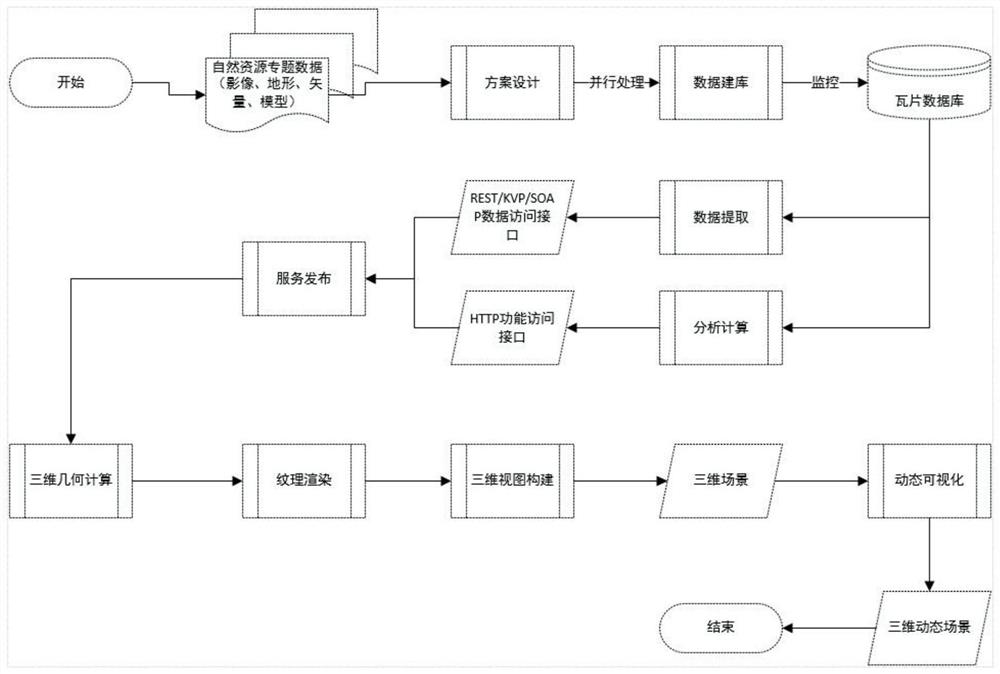
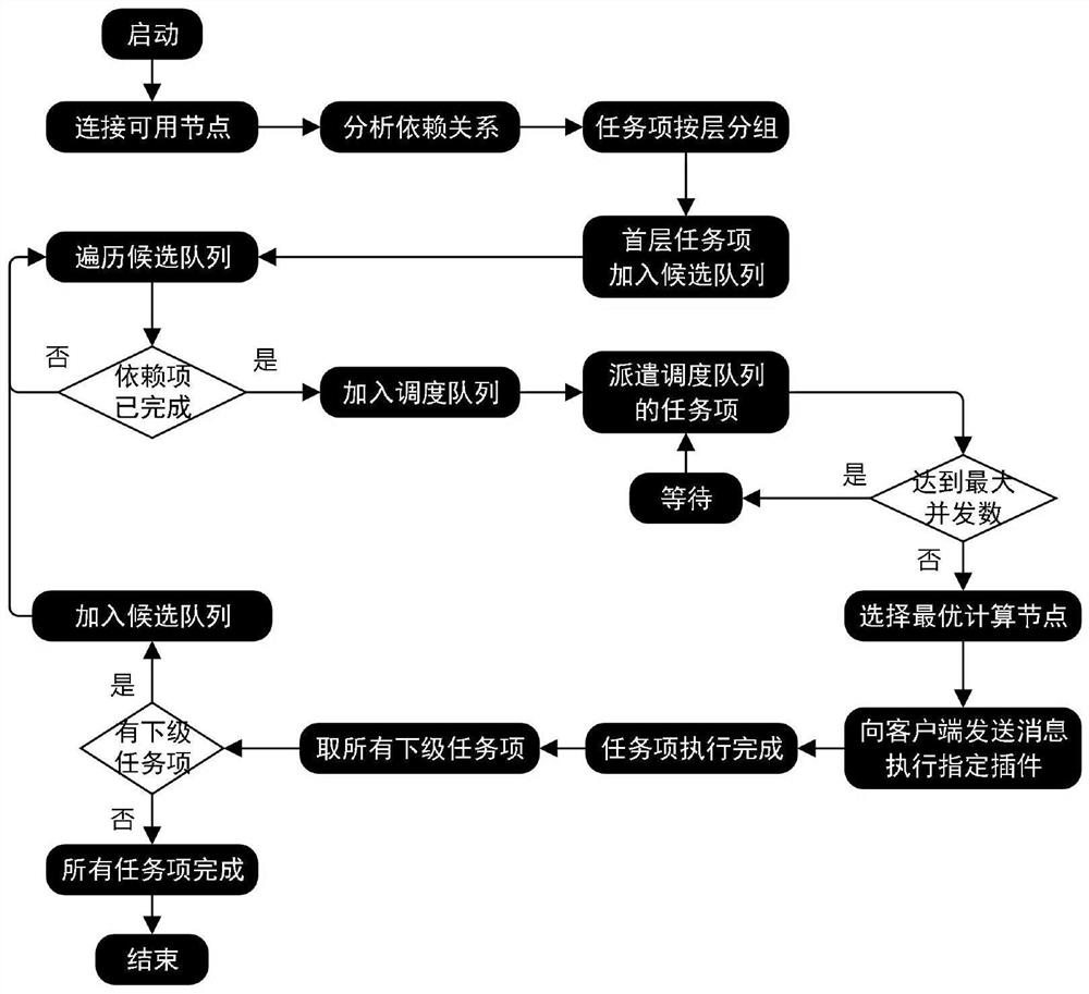
[0038] According to the embodiment of the present invention, an autonomously controllable three-dimensional natural resource map system construction method includes three parts: data layer construction, service layer construction and application layer construction.

[0039] Data layer construction: Realize the storage and management of various types of spatial data and 3D datasets such as images, topography, vectors, place names, and 3D models, and provide the design and processing of database...


PUM


Abstract

The invention discloses an autonomously controllable three-dimensional natural resource one-graph system construction method, which comprises the following steps of: creating a library construction scheme of three-dimensional space data, performing library construction processing on original space data through a parallel processing mechanism, generating a three-dimensional data set which can be used for service release, and generating a three-dimensional natural resource one-graph system; wherein the three-dimensional data set supports a sky map tile pyramid standard; performing data extraction on the three-dimensional data set, and issuing a data service supporting an REST or KVP or SOAP protocol; analyzing, calculating and publishing the three-dimensional data set to support a functionalservice of an HTTP protocol; and sequentially performing three-dimensional geometric calculation, texture rendering, three-dimensional view construction and dynamic visualization on the published function service and data service to form a three-dimensional dynamic scene. According to the invention, publishing and management of various data services and functional services of the two-dimensionaland three-dimensional space data are supported, the external sharing capability of the two-dimensional and three-dimensional space data services is effectively improved, and the safety controllabilityof geographic information management is greatly improved.

Description

technical field [0001] The invention relates to the field of natural resource informatization, and specifically relates to an autonomous and controllable three-dimensional natural resource one map system construction method. Background technique [0002] In the field of natural resources informatization, it is necessary to integrate, integrate and standardize various databases of land, geology, minerals, oceans, surveying and mapping geographic information, etc., and build a unified natural resource "integration" of "above ground, underground, land and sea" in accordance with unified standards. Zhangtu" big data system. Based on full coverage, all elements, and three-dimensional survey and monitoring, continuously improve the accuracy and integrity of "one map" data, and strengthen the management and application of three-dimensional space natural resource information. [0003] However, the current construction of a "one map" of three-dimensional natural resources lacks a co...

Claims


Application Information

Patent Timeline
Patent Type & Authority Applications(China)
IPC IPC(8): G06T17/05G06F16/9537G06F16/29G06T15/00G06T15/04G06T15/20H04L29/08
CPCG06T17/05G06F16/9537G06F16/29G06T15/005G06T15/04G06T15/205H04L67/02
Inventor 练栩陈鑫祥刘雪俊刘思洁蒋凤钗
Owner 广东省国土资源技术中心
Learn More