Flood inundation prediction method based on remote sensing

A forecasting method and flood technology, applied in forecasting, instrumentation, climate change adaptation, etc., can solve problems such as economic and social losses, and achieve the effects of high accuracy, small calculation amount, and low cost

Pending Publication Date: 2021-02-19
AEROSPACE INFORMATION RES INST CAS
View PDF0 Cites 1 Cited by
  • Summary
  • Abstract
  • Description
  • Claims
  • Application Information

AI Technical Summary

Problems solved by technology

[0006] In order to solve the problem of the lack of hydrological measured data in small and medium watersheds in developing countries or underdeveloped areas in the existing technology, it is difficult to effectively use the existing hydrological and hydraulic models to predict the dynamic development of rainstorm and flood disasters, resulting in huge In view of the technical problem of economic and social losses, the present invention provides a remote sensing-based flood submersion prediction method. The present invention uses the hydrological parameter information monitored by remote sensing to analyze the hydrological laws of the river, and further provide solutions for developing countries that lack hydrological measured data according to the hydrological laws. Early warning of flood disasters in small and medium-sized watersheds in countries or underdeveloped areas, and fully consider the hydraulic gradient existing in the upper and lower reaches of the river, which is beneficial to the simulation prediction of flood inundation when the flood evolves downstream. The present invention has the advantages of small calculation amount, accurate The beneficial effect of high degree and low cost

Method used


Image

  • Flood inundation prediction method based on remote sensing
  • Flood inundation prediction method based on remote sensing
  • Flood inundation prediction method based on remote sensing

Examples


Embodiment Construction

[0044]Best practice

[0045]In order to enable those skilled in the art to more clearly understand the flood inundation prediction method based on remote sensing provided by the present invention, it will be described in detail below with reference to the accompanying drawings.

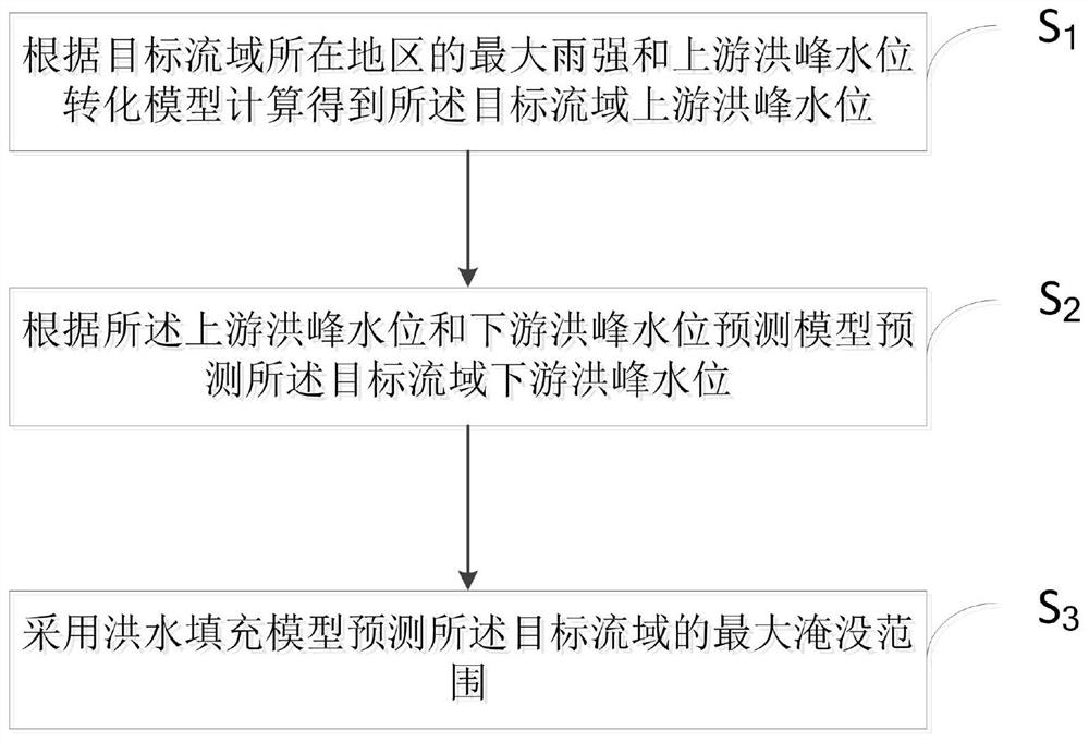
[0046]Such asfigure 1 As shown, the embodiment of the present invention provides a method for flood inundation prediction based on remote sensing, which specifically includes the following steps:

[0047]S1: Calculate the upstream flood peak water level of the target watershed based on the maximum rain intensity in the area where the target watershed is located and the upstream flood peak water level conversion model;

[0048]It should be noted that the present invention is mainly applied to flood inundation prediction of small and medium-sized watersheds in developing or underdeveloped areas, and the level of socio-economic development of small and medium-sized watersheds in developing or underdeveloped areas is often...


PUM


Abstract

The invention belongs to the field of flood disaster early warning, and provides a flood inundation prediction method based on remote sensing, and the method specifically comprises the steps: obtaining the upstream flood peak water level of a target drainage basin through calculation according to the maximum rain intensity of the region where the target drainage basin is located and an upstream flood peak water level conversion model; predicting the downstream flood peak water level of the target drainage basin according to the upstream flood peak water level and downstream flood peak water level prediction model of the target drainage basin; and predicting the maximum flooding range of the target drainage basin by adopting a flood filling model. The river hydrological law is analyzed by utilizing hydrological parameter information monitored by remote sensing, early warning is further performed on flood disasters of medium and small watersheds of developing countries or underdevelopedareas lacking hydrological actual measurement data according to the hydrological law, and the hydraulic gradient existing in the upstream and downstream water surfaces of a river reach is fully considered, thereby facilitating the flood inundation simulation prediction under condition that flood evolves to downstream. The method has the advantages of being small in calculated amount, high in accuracy and low in cost.

Description

Technical field[0001]The present invention relates to the field of flood disaster early warning, in particular to a method for predicting flood inundation based on remote sensing.Background technique[0002]Natural disasters have always been an important factor restricting human production activities, affecting all aspects of people’s lives. Flooding disasters have become the most important factor in the world today due to their wide range, high frequency, strong suddenness, large damage and serious subsequent effects. One of the natural disasters. With the impact of climate change and extreme rainstorms, the frequency and intensity of flood disasters continue to increase. According to the "Economic Losses, Poverty and Disasters 1998-2017" report issued by the United Nations Office for Risk Reduction and Disaster Reduction, more than 7,000 global records have been recorded in the past 20 years. There were major disasters, 43.4% of which were related to floods.[0003]Flood disasters hav...

Claims


Application Information

Patent Timeline
IPC IPC(8): G06Q10/04G06Q50/26G06Q10/06
CPCG06Q10/04G06Q50/26G06Q10/067Y02A10/40
Inventor 阎福礼范湘涛高龙
Owner AEROSPACE INFORMATION RES INST CAS
Why Eureka
Try Eureka