A three-dimensional imaging method and system for resistivity data fusion for landslide detection

A technology of data fusion and three-dimensional imaging, applied in radio wave measurement systems, measurement devices, using re-radiation, etc., can solve problems such as false anomalies, unfavorable landslide surface distribution range, and inaccurate detection of landslides

Active Publication Date: 2021-07-06
SHANDONG UNIV
View PDF6 Cites 0 Cited by
  • Summary
  • Abstract
  • Description
  • Claims
  • Application Information

AI Technical Summary

Problems solved by technology

[0004] The inventor found that due to the limitations of the method itself, the single geophysical prospecting method may not be accurate enough when detecting landslides, and many false anomalies will be obtained after inversion imaging, and the position of the landslide surface cannot be accurately determined
These geophysical prospecting methods can obtain resistivity data after various inversion methods, but the obtained resistivity profile is two-dimensional, which is not conducive to determining the distribution range of landslide surface in space

Method used


Image

  • A three-dimensional imaging method and system for resistivity data fusion for landslide detection
  • A three-dimensional imaging method and system for resistivity data fusion for landslide detection
  • A three-dimensional imaging method and system for resistivity data fusion for landslide detection

Examples


Embodiment 1

[0036] This embodiment provides a resistivity data fusion three-dimensional imaging method for landslide detection, including:

[0037] Obtain geophysical data according to various geophysical detection lines laid out;

[0038] Preprocess the geophysical prospecting data and obtain two-dimensional resistivity data through the inversion method;

[0039] Extract the resistivity data of multiple geophysical prospecting methods at the same location, and fuse the multiple resistivity data;

[0040] Establish a three-dimensional coordinate system, convert the fused two-dimensional detection data into three-dimensional detection data, and obtain a three-dimensional stereogram after imaging the three-dimensional detection data.

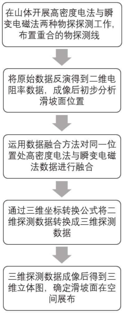
[0041] Specifically, such as figure 1 shown, including the following steps:

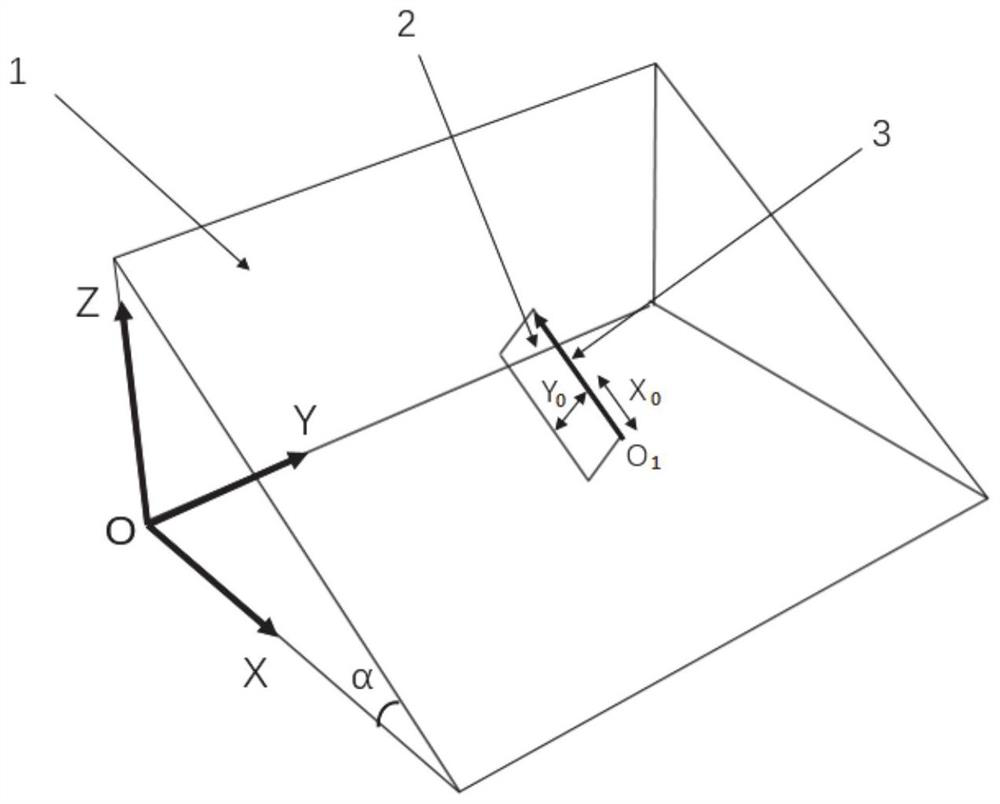
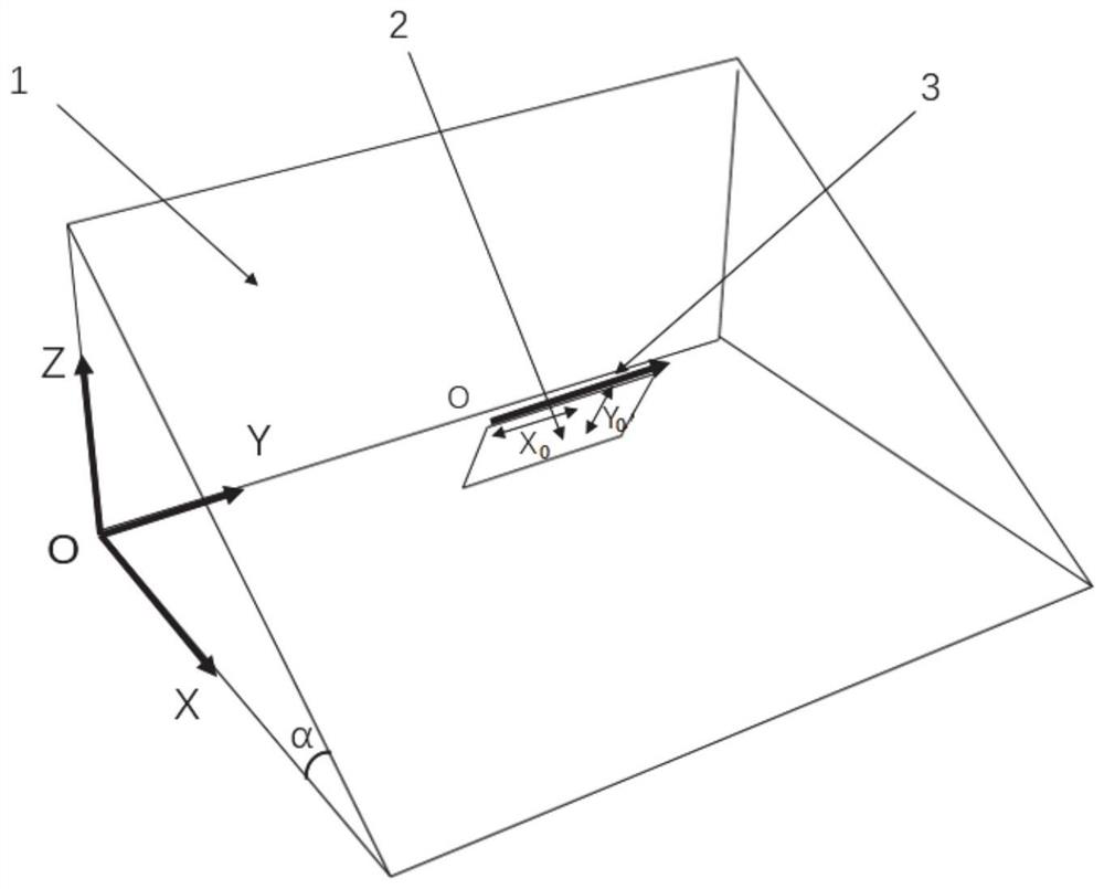
[0042] Step 1: Carry out two kinds of geophysical exploration work of high-density electrical method and transient electromagnetic method on the mountain body 1. When detecting ...

Embodiment 2

[0063] This embodiment provides a resistivity data fusion three-dimensional imaging system for landslide detection, including:

[0064] The geophysical prospecting data acquisition module is used to acquire geophysical prospecting data according to the laid multiple geophysical prospecting lines;

[0065] The two-dimensional resistivity data acquisition module is used to preprocess the geophysical data and obtain the two-dimensional resistivity data through the inversion method;

[0066] The data fusion module is used to extract the resistivity data of multiple geophysical prospecting methods at the same position, and to fuse the multiple resistivity data;

[0067] The three-dimensional detection data acquisition module is used to establish a three-dimensional coordinate system, convert the fused two-dimensional detection data into three-dimensional detection data, and obtain a three-dimensional stereogram after imaging the three-dimensional detection data.

Embodiment 3

[0069] This embodiment provides an electronic device, including a memory, a processor, and a computer program stored in the memory and operable on the processor. When the processor executes the program, the method for landslide described in Embodiment 1 Probe resistivity data are fused with 3D imaging methods.


PUM


Abstract

The invention discloses a three-dimensional imaging method and system for resistivity data fusion for landslide detection. The technical solution is as follows: obtaining geophysical data according to various geophysical detection lines laid out; preprocessing the geophysical data, and passing Obtain two-dimensional resistivity data by inversion method; extract resistivity data of multiple geophysical prospecting methods at the same position, and fuse multiple resistivity data; establish a three-dimensional coordinate system, and convert the fused two-dimensional detection data into three-dimensional detection Data, the three-dimensional detection data is imaged to obtain a three-dimensional stereogram. The invention fuses the two-dimensional detection data obtained by the inversion of the transient electromagnetic method and the high-density electric method, and obtains the three-dimensional detection data through the three-dimensional coordinate conversion formula, and finally obtains the three-dimensional stereogram after the three-dimensional detection data is imaged, thereby determining the sliding surface in space distribution range.

Description

technical field [0001] The invention relates to the technical field of landslide detection, in particular to a resistivity data fusion three-dimensional imaging method and system for landslide detection. Background technique [0002] Landslides are one of the most serious geological disasters. Therefore, finding out the spatial position of the landslide surface (the interface where the landslide body slides along the underlying rock and soil) is very important for the stability analysis of landslide bodies, governance decisions and landslide disaster risk management. etc. are of great significance. [0003] The occurrence of landslides is often closely related to the action of water, and the action of water is often the main factor causing landslides. The higher the water content, the lower the resistivity, so the landslide surface often shows low resistance. This difference in physical properties lays the foundation for the use of geophysical methods to detect landslides. ...

Claims


Application Information

Patent Timeline
Patent Type & Authority Patents(China)
IPC IPC(8): G01V3/38
CPCG01V3/38
Inventor 苏茂鑫程凯薛翊国刘轶民李广坤
Owner SHANDONG UNIV
Why Eureka
Try Eureka