
Road effective earth volume calculation method based on oblique photography technology

A technology of oblique photography and calculation method, which is applied in the direction of photogrammetry/video measurement, calculation, measuring device, etc., can solve the problems that affect the budget and settlement of road projects, the results are unbelievable, and the efficiency is low, so as to improve the scientific Sex and rationality, the effect of improving calculation accuracy and work efficiency

Inactive Publication Date: 2020-10-13
CHINA MCC20 GRP CORP
View PDF11 Cites 6 Cited by
  • Summary
  • Abstract
  • Description
  • Claims
  • Application Information

AI Technical Summary

Problems solved by technology

The designed earthwork volume is affected by multiple factors such as survey data, technical parameters, design software and designer experience, resulting in a large error between the earthwork volume and the actual situation
During the construction process, due to overfilling and overexcavation, the results of the actual earthwork volume will also be unbelievable.
Moreover, the above two earthwork determination methods are cumbersome to operate, low in efficiency, and poor in accuracy, which seriously affects the budget and settlement of road projects

Method used


Image

  • Road effective earth volume calculation method based on oblique photography technology

Examples


Embodiment Construction

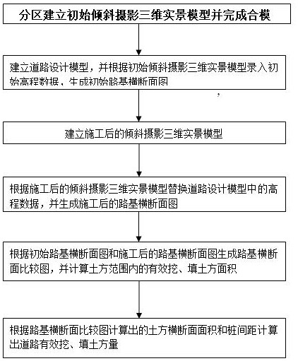
[0024] Example figure 1 As shown, the present invention is based on the road effective earthwork calculation method of oblique photography technology and comprises the following steps:

[0025] Step 1, collecting and sorting out road location data and road construction drawings;

[0026] Step 2. Determine the UAV aerial photography route and aerial photography parameters according to the site survey and electronic map, use the UAV to take pictures according to the aerial photography route and aerial photography parameters, obtain the preliminary oblique photography data of each partition, and use the aerial photography pos data to remove unnecessary and redundant data, generate the initial oblique photographic three-dimensional real scene model of each partition in the shooting area;

[0027] Among them, unnecessary and redundant data refers to oblique photographic data beyond the scope of the project and abnormal oblique photographic data, such as data in oblique photography...


PUM


Abstract

The invention discloses a road effective earth volume calculation method based on an oblique photography technology, and the method comprises the steps: carrying out the photographing of a road regionthrough an unmanned plane, obtaining preliminary oblique photography data, and generating an initial oblique photography three-dimensional live-action model; inputting the elevation data into a roaddesign model; generating an initial roadbed cross section diagram in a road design model according to the elevation data; generating a constructed oblique photography three-dimensional live-action model after the road construction is completed; replacing the elevation data in the road design model with the constructed elevation data to generate a constructed roadbed cross section diagram; generating a roadbed cross section comparison diagram according to the same pile number, and calculating the cross section areas of effective excavation and earth filling squares; and according to the cross section areas and distances of the effective excavated and filled earthwork squares, calculating the effective excavated and filled earthwork squares, and taking the sum of the effective excavated andfilled earthwork squares of each road section as the effective earthwork volume of the road. According to the method, the scientificity and reasonability of road earth volume calculation are improved,and a reliable basis is provided for budget and settlement of road engineering.

Description

technical field [0001] The invention relates to the technical field of road engineering, in particular to a calculation method for road effective earthwork volume based on oblique photography technology. Background technique [0002] There are various methods for calculating or determining the earthwork volume of roads, but most of them consider single factors in the calculation process of earthwork volume, which makes it difficult to popularize and use them. For example, two commonly used earthwork determination methods in engineering are: 1) the design earthwork determined according to the survey data and technical parameter settings during the design process of the project; 2) the actual earthwork generated during the construction process. The designed earthwork volume is affected by multiple factors such as survey data, technical parameters, design software and designer experience, resulting in a large error between the earthwork volume and the actual situation. During ...

Claims


Application Information

Patent Timeline
IPC IPC(8): G01C11/00G01C7/02G01C11/02G06T17/05
CPCG01C11/00G01C11/02G01C7/02G06T17/05
Inventor 徐宁李印冬杨华杰王银武龙也
Owner CHINA MCC20 GRP CORP
Learn More