Fusion positioning method

A technology that integrates positioning and variance matrix, applied in the field of car navigation and positioning, can solve problems such as inability to provide positioning services, failure, and inaccurate positioning

Inactive Publication Date: 2020-09-22
NANJING XIAOZHUANG UNIV
View PDF6 Cites 3 Cited by
  • Summary
  • Abstract
  • Description
  • Claims
  • Application Information

AI Technical Summary

Problems solved by technology

However, when the vehicle is driving in an occluded environment such as a tunnel, the GPS signal will be inaccurate or even invalid due to the occlusion of the signal, and it will not be able to provide accurate positioning services

Method used


Image

  • Fusion positioning method
  • Fusion positioning method
  • Fusion positioning method

Examples


Embodiment Construction

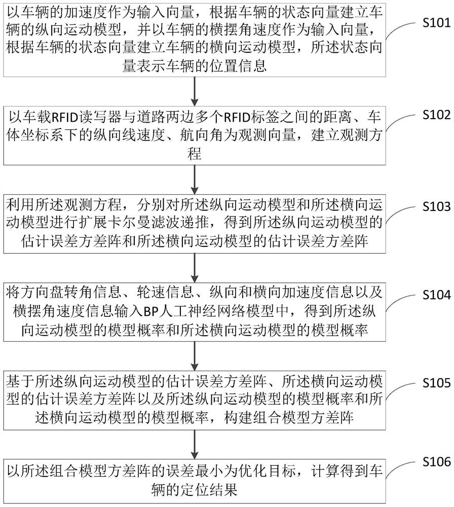
[0033] The following will clearly and completely describe the technical solutions in the embodiments of the present invention with reference to the accompanying drawings in the embodiments of the present invention. Obviously, the described embodiments are only some, not all, embodiments of the present invention. Based on the embodiments of the present invention, all other embodiments obtained by persons of ordinary skill in the art without making creative efforts belong to the protection scope of the present invention.

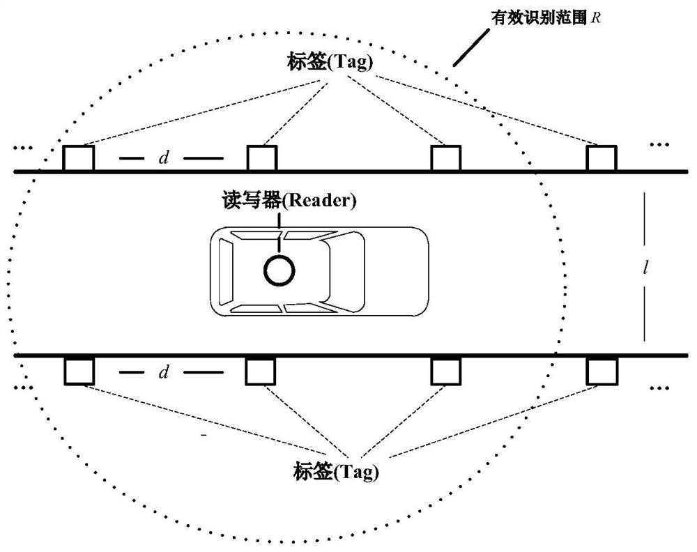
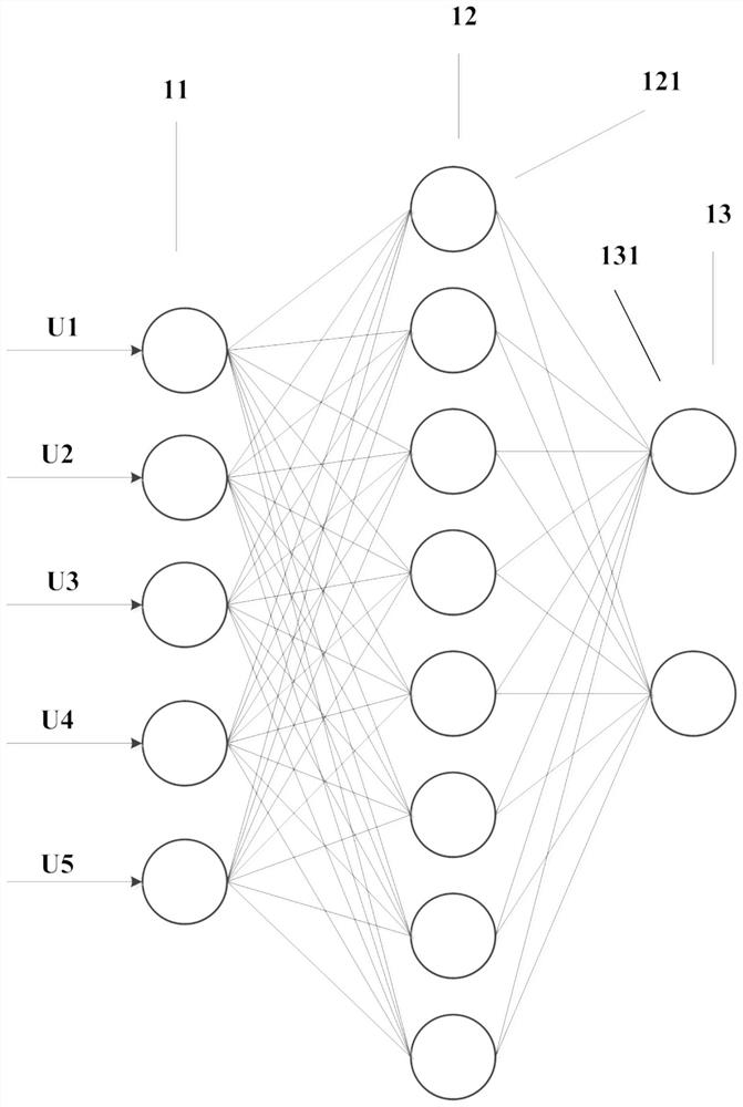
[0034] The present invention proposes an intelligent multi-model fusion positioning method using a neural network for model probability calculation, which is used to realize the fusion positioning of RFID and vehicle sensors in tunnels and other sheltered environments, which can adapt to vehicle operating characteristics and obtain accurate and reliable positioning results.

[0035] Specifically, see figure 1 A fusion positioning method disclosed in this embo...


PUM


Abstract

The invention provides a fusion positioning method. The method is characterized in that the information acquired by a wireless radio frequency technology and a vehicle-mounted sensor is used as the observation information, a longitudinal motion model and a transverse motion model of the vehicle are respectively established as state equations, extended Kalman filtering recursion is carried out on the two models respectively, the real-time vehicle motion state information is used as input, a BP (Back Propagation) neural network model is established to determine the model probabilities of the twomodels, and multi-model estimation combination is realized according to the model probability, and an intelligent multi-model fusion method is formed. The method is advantaged in that real-time switching between the longitudinal motion model and the transverse motion model is achieved according to a motion state of a vehicle, that the state equation can accord with the actual motion state of thevehicle is guaranteed, and accurate and reliable positioning of the running vehicle in the tunnel and other shielded environments is achieved.

Description

technical field [0001] The invention relates to the technical field of car navigation and positioning, and more specifically, to a fusion positioning method. Background technique [0002] In recent decades, the trend of urbanization in various countries has become more and more obvious. There are more and more vehicles in cities. In order to alleviate the traffic pressure in cities, there are more and more underground tunnels and multi-level interchanges. [0003] At present, GPS (Global Positioning System, Global Positioning System) is generally used for vehicle navigation. GPS can provide information such as three-dimensional position, speed and time for moving carriers in real time and around the clock, and is the most widely used positioning technology. However, when the vehicle is driving in an occluded environment such as a tunnel, the GPS signal will be inaccurate or even invalid due to the occlusion of the signal, and it cannot provide accurate positioning services. ...

Claims


Application Information

Patent Timeline
Patent Type & Authority Applications(China)
IPC IPC(8): G01C21/16G06N3/04G06N3/08
CPCG01C21/165G06N3/084G06N3/045
Inventor 宋翔赵婷谢军张磊蒋慧琳
Owner NANJING XIAOZHUANG UNIV
Why Eureka
Try Eureka