Method for acquiring super-resolution land cover classification map based on deep learning

A super-resolution and deep learning technology, applied in the field of obtaining super-resolution land cover classification maps, can solve problems such as ambiguity, inaccuracy, and inability to add useful information to high-resolution images, and achieve outliers and inaccuracies. uniform smooth effect

Active Publication Date: 2020-07-10
BEIJING NORMAL UNIVERSITY
View PDF5 Cites 5 Cited by
  • Summary
  • Abstract
  • Description
  • Claims
  • Application Information

AI Technical Summary

Problems solved by technology

[0008] An embodiment of the present invention provides a method for obtaining a super-resolution land cover classification map based on deep learning, which is used to solve the ambiguity of the obtained high-resolution image caused by the existing method for obtaining a super-resolution land cover classification map and inaccurate, unable to add more useful information to the question

Method used


Image

  • Method for acquiring super-resolution land cover classification map based on deep learning
  • Method for acquiring super-resolution land cover classification map based on deep learning
  • Method for acquiring super-resolution land cover classification map based on deep learning

Examples


Embodiment Construction

[0045] In order to make the purpose, technical solutions and advantages of the embodiments of the present invention clearer, the technical solutions in the embodiments of the present invention will be clearly and completely described below in conjunction with the drawings in the embodiments of the present invention. Obviously, the described embodiments It is a part of embodiments of the present invention, but not all embodiments. Based on the embodiments of the present invention, all other embodiments obtained by persons of ordinary skill in the art without making creative efforts belong to the protection scope of the present invention.

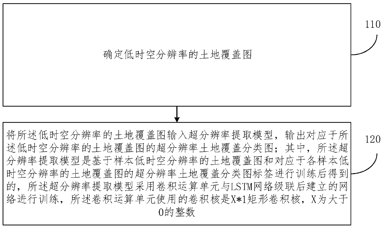
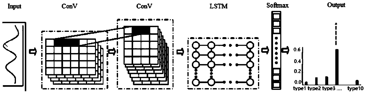
[0046] The existing methods for obtaining super-resolution land cover classification maps generally have the problem that the obtained high-resolution images are unclear and inaccurate, and cannot add more useful information. In this regard, an embodiment of the present invention provides a method for obtaining a super-resolution land cover c...


PUM


Abstract

The embodiment of the invention provides a method for obtaining a super-resolution land cover classification map based on deep learning, and the method comprises the steps: inputting a land cover mapwith a low spatial-temporal resolution into a super-resolution extraction model, and outputting the super-resolution land cover classification map corresponding to the land cover map with the low spatial-temporal resolution, wherein the super-resolution extraction model is obtained by training a land cover map based on low spatial-temporal resolutions of samples and super-resolution land cover classification map labels corresponding to the land cover maps of the low spatial-temporal resolutions of the samples; the super-resolution extraction model is trained by adopting a network established after a convolution operation unit and an LSTM network are cascaded, a convolution kernel used by the convolution operation unit is an X * 1 rectangular convolution kernel, and X is an integer greaterthan 0. According to the method provided by the embodiment of the invention, a more accurate and clearer super-resolution land cover classification map is obtained.

Description

technical field [0001] The invention relates to the technical field of deep learning, in particular to a method for obtaining a super-resolution land cover classification map based on deep learning. Background technique [0002] Land cover refers to the general term of vegetation cover and artificial cover on the earth's surface, and it is a comprehensive reflection of natural vegetation, natural construction and artificial construction. Land cover is the necessary information for humans to understand nature and master the laws of nature, and it is also the most basic data required for various resource management and geographic information services. Therefore, the acquisition, analysis and update of land cover information is extremely important. [0003] Because of its macroscopic and real-time characteristics, remote sensing image data has always been an important means of land cover detection. At present, land cover classification methods based on remote sensing data are...

Claims


Application Information

Patent Timeline
Patent Type & Authority Applications(China)
IPC IPC(8): G06T3/40G06K9/62G06N3/04G06N3/08
CPCG06T3/4053G06N3/08G06N3/044G06N3/045G06F18/24
Inventor 赵祥王昊宇
Owner BEIJING NORMAL UNIVERSITY
Why Eureka
Try Eureka