Walking navigation method based on directed label

A walking navigation and labeling technology, applied in the field of navigation, can solve the problems of ineffective navigation capability, inability to locate users, and instable methods, so as to reduce the processing load.

Pending Publication Date: 2020-07-10
NANJING SOARING CYBER REALITY INNOVATION CENT CO LTD
View PDF0 Cites 3 Cited by
  • Summary
  • Abstract
  • Description
  • Claims
  • Application Information

AI Technical Summary

Problems solved by technology

However, when the GPS, WIFI or Bluetooth signal of the user terminal is disconnected, these electronic maps cannot locate the user's current position and orientation, resulting in the failure of the navigation capability.
[0004] Chinese literature "[1] Zhou Sha. Research on Key Technologies of Pedestrian Navigation Based on Landmarks [D]. China University of Geosciences, 2017." proposed a landmark-based pedestrian orientation prediction method, which requires a set of 360-degree panoramic photos taken in advance , and then match the image currently captured by the camera to predict the person's position and orientation. This method requires a lot of image acquisition work in the early stage. When the weather, light or scene changes, it is difficult to match the current image, so this method is not enough. Stable, but difficult to implement in practice

Method used


Image

  • Walking navigation method based on directed label
  • Walking navigation method based on directed label
  • Walking navigation method based on directed label

Examples


Embodiment

[0046] Step 1: The user opens the lightweight electronic navigation map through the navigation software in the mobile terminal, and inputs the destination location. The generation of the lightweight electronic navigation map includes the following steps:

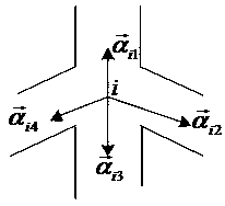
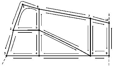
[0047] (1) Define the intersection information: the junction point where the user chooses the direction is taken as the intersection vertex of the electronic map, and the No. 1 vertex is a road turning point, which does not need to be selected by the user, so it will not be set as the vertex of the electronic map ;

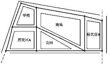
[0048] (a) Constructing a vertex set: there are a total of 9 intersections in the physical space that need to be reflected on the electronic map, and the vertex sets of the 9 intersections are expressed as V(D)={2,3,4,5,6,7 ,8,9,10} represent the vertices at each intersection in the block map;

[0049] (b) Define vertex information: for each vertex V i , i=2,3...,10 contains the number and name information rel...


PUM


Abstract

The invention discloses a walking navigation method based on a directed label, which comprises the following steps that: 1, a user opens a lightweight electronic navigation map through navigation software in a mobile terminal and inputs a destination position; 2, the user turns on a camera on the mobile terminal through the navigation software to scan a directed label at the intersection, and judges the current position and orientation according to the position and direction information contained in the directed label; 3, the user searches a corresponding destination vertex and a current position vertex in the lightweight electronic navigation map according to the current position and orientation obtained by the user and the input destination position, and plans a shortest path; and 4, theuser selects a branch road of the current intersection according to the planned shortest path, and navigation guide information is accurately presented on the lightweight electronic navigation map according to the current orientation to enable the user to quickly complete the navigation. According to the invention, the processing load of a user on a large amount of information in the way-findingprocess is reduced, and the method does not depend on the Internet.

Description

technical field [0001] The invention relates to navigation technology, in particular to a walking navigation method based on directional tags. Background technique [0002] At present, most of the intersections of shopping malls, parks and urban roads are provided with traffic guide signs to indicate intersection information and provide information support for people's wayfinding. Although the amount of information provided by this wayfinding guidance method is limited and navigation guidance cannot be carried out, this guidance method fully combines people's perception and judgment ability, and only provides information support at intersections that require people to make direction choices. The implementation is simple and the cost is low. . [0003] With the development of navigation technology, common electronic maps such as Google Maps, Baidu Maps, and AutoNavi Maps all have good outdoor navigation functions, and individual electronic maps already have indoor navigation...

Claims


Application Information

Patent Timeline
Patent Type & Authority Applications(China)
IPC IPC(8): G01C21/34
CPCG01C21/34G01C21/3446
Inventor 常壮白晓亮邵立
Owner NANJING SOARING CYBER REALITY INNOVATION CENT CO LTD
Why Eureka
Try Eureka