Satellite map aided navigation positioning method based on deep learning

A satellite map and assisted navigation technology, which is applied in the fields of autonomous navigation and target detection, unmanned aerial vehicle, and satellite map assisted navigation and positioning, can solve the problems of poor remote sensing image extraction and matching, and consumption, so as to reduce memory consumption and solve the problem of The effect of accumulating drift errors and overcoming poor feature extraction and matching effects

Active Publication Date: 2020-04-17
ZHEJIANG UNIV
View PDF11 Cites 8 Cited by
  • Summary
  • Abstract
  • Description
  • Claims
  • Application Information

AI Technical Summary

Problems solved by technology

Aiming at the positioning problem of UAVs in complex electromagnetic environments, XiJia Liu et al. proposed interval storage of known maps on routes, and used improved SIFT to extract the features of these images. During the flight, the real-time aerial images were combined with the features The real-time position of the UAV is obtained after the coordinate solution. The disadvantage of this method is that the feature extraction and matching effect of the remote sensing image is not good, and storing a large amount of feature information is very difficult for the memory of the UAV onboard computer. big consumption

Method used


Image

  • Satellite map aided navigation positioning method based on deep learning
  • Satellite map aided navigation positioning method based on deep learning
  • Satellite map aided navigation positioning method based on deep learning

Examples


Embodiment Construction

[0015] The present invention will be further elaborated and illustrated below in conjunction with the accompanying drawings and specific embodiments. The technical features of the various implementations in the present invention can be combined accordingly on the premise that there is no conflict with each other.

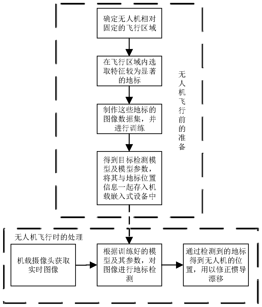
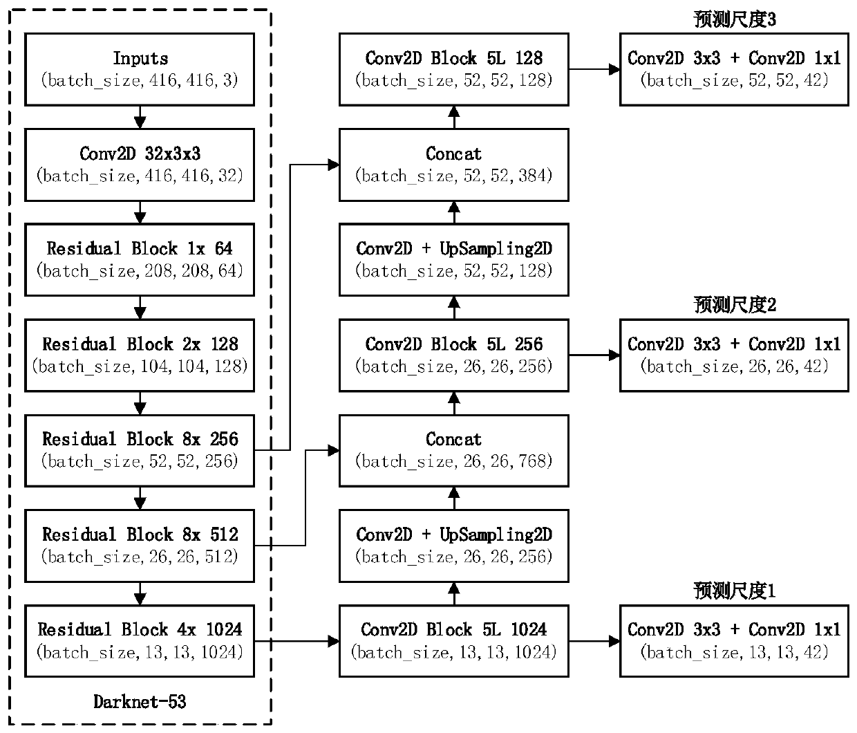
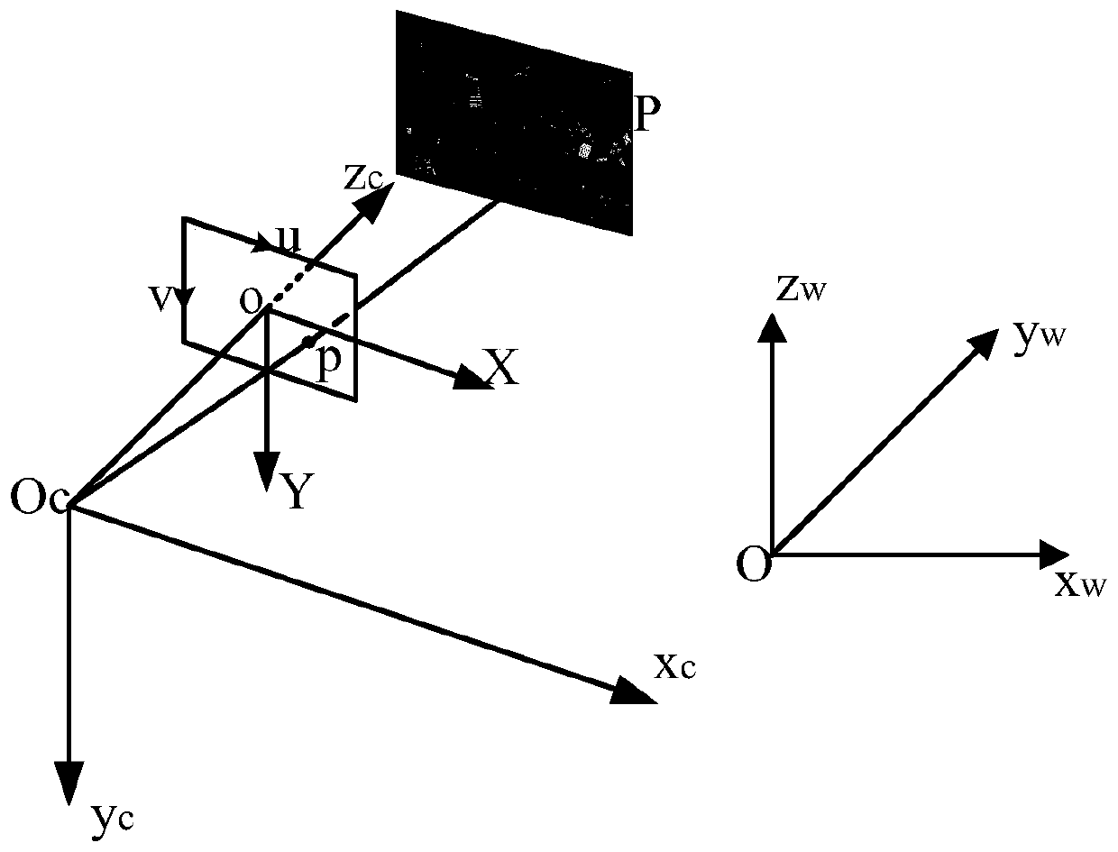
[0016] Examples of the present invention provide a satellite map-assisted navigation and positioning method based on deep learning, such as figure 1 shown, including:

[0017] Step 1: Select the landmark points on the route to make an image data set, uniformly select 9 landmarks with obvious characteristics in the target area, and obtain the different positions, different tilt angles, different viewing angles, and heights of these 9 landmarks from the Google Earth Pro software. Satellite remote sensing images with different compass angles, the data set is expanded by rotating angle, horizontal flip, adjusting saturation, adjusting exposure, adjusting color, etc., t...


PUM


Abstract

The invention relates to a satellite map auxiliary navigation positioning method based on deep learning, is applied to an unmanned aerial vehicle and solves a navigation positioning problem during GNSS unlocking. The method comprises steps 1, selecting an image landmark point in a flight area according to a drift error of inertial navigation equipment, 2, establishing a target detection data set according to satellite remote sensing images at landmark points, and training by using improved YOLO v3, 3, in the flight process, detecting landmark points with the known position information according to a trained model and model parameters, and obtaining the position of an unmanned aerial vehicle through the coordinate transformation relation; and 4, utilizing Kalman filtering to fuse the position parameters outputted by an INS system, and achieving integrated navigation. The method is advantaged in that aiming at the condition that the GNSS of the unmanned aerial vehicle is unlocked, auxiliary navigation and positioning are realized by utilizing target detection, and a problem of accumulated drift error of a single INS system is effectively solved.

Description

technical field [0001] The invention relates to the field of unmanned aerial vehicles, in particular to the field of satellite map-assisted navigation and positioning based on deep learning, and belongs to the technical fields of unmanned aerial vehicles, autonomous navigation, and target detection. Background technique [0002] During the flight of UAVs, if the inertial navigation equipment is not corrected, it will form cumulative drift errors. One of the common solutions is INS / GNSS integrated navigation, but in complex electromagnetic environments, GNSS signals are susceptible to interference. With the development of computer vision, and visual sensors are hardly affected by the electromagnetic environment, visual navigation technology has been widely researched and applied in recent years. When the environment is unknown and the task area is small, SLAM (simultaneous localization and mapping) can be used for map construction and positioning. Aiming at the positioning p...

Claims


Application Information

Patent Timeline
IPC IPC(8): G01C21/16G01C21/00
CPCG01C21/005G01C21/165
Inventor 赵文杰周棚
Owner ZHEJIANG UNIV
Why Eureka
Try Eureka