GPS signal-to-noise ratio snow depth inversion method assisted by support vector machine

A technology of support vector machine and signal-to-noise ratio, applied in measuring devices, rainfall/precipitation gauges, radio wave measurement systems, etc., can solve problems such as deviation, jump and deviation of inversion results

Inactive Publication Date: 2020-03-27
GUILIN UNIVERSITY OF TECHNOLOGY
View PDF0 Cites 5 Cited by
  • Summary
  • Abstract
  • Description
  • Claims
  • Application Information

AI Technical Summary

Problems solved by technology

[0007] The present invention proposes a GPS signal-to-noise ratio snow depth inversion method assisted by a support vector machine to solve the problem of being easily affected by the observation quality of a single GPS satellite and jumping and jumping in the current international use of GPS-IR single-satellite inversion of snow depth. The key technical problem that the inversion results greatly deviate from the measured snow depth caused by the deviation problem

Method used


Image

  • GPS signal-to-noise ratio snow depth inversion method assisted by support vector machine
  • GPS signal-to-noise ratio snow depth inversion method assisted by support vector machine
  • GPS signal-to-noise ratio snow depth inversion method assisted by support vector machine

Examples


Embodiment Construction

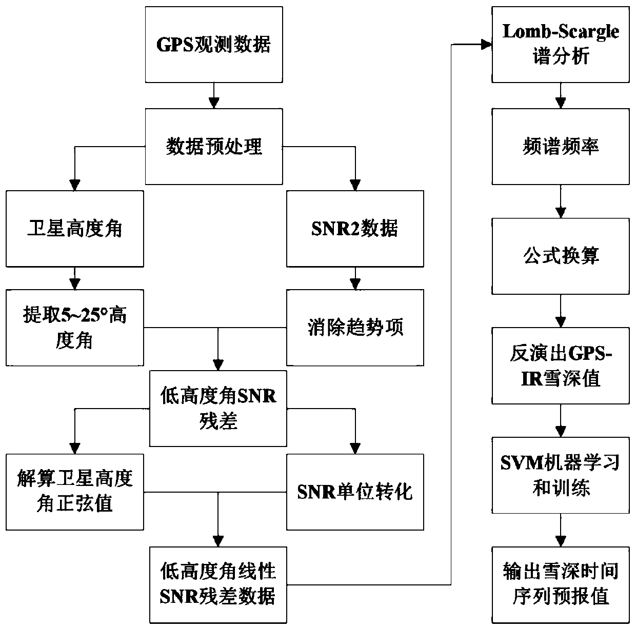
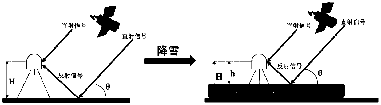
[0025] Below, the specific embodiment of the present invention will be further described in conjunction with the accompanying drawings of examples in the description of drawings of the present invention:

[0026] In this embodiment, the GPS monitoring data and actual snow depth comparison and verification data used for snow depth inversion are obtained from the Plate Boundary Observatory (Plate Boundary Observatory, http: / / pboweb.unavco) of the Earthscope program (Earthscope) of the United States. .org) available.

[0027] This embodiment selects the P101 survey station (111.236° west longitude, 41.692° north latitude) that the US Earth Lens plans to deploy in the Randolph (State of Utah) area of ​​the United States. A total of 135 days of GPS observation data per year, the basic parameters of the station are as follows: The receiver type is TRIMBLE NETRSGPS, the antenna type is TRM29659.00, the fairing type is SCIT, the station height is 2m, the sampling rate is 15s, and the ...


PUM


Abstract

The invention discloses a GPS signal-to-noise ratio snow depth inversion method assisted by a support vector machine, and the method comprises the steps: firstly carrying out the preprocessing of GPSdata through a quadratic term fitting method, and obtaining the direct reflection signals of all GPS satellites in batch; analyzing the direct reflection signal to separate out satellite altitude angle information and signal-to-noise ratio data of 5-25 degrees, and performing trend term and unit conversion on signal-to-noise ratio elimination to obtain low altitude angle linear signal-to-noise ratio residual data; performing Lomb-Scargle spectrum analysis on the low altitude angle linear signal-to-noise ratio residual error data to calculate a spectrum frequency, solving a difference value between a vertical distance of a receiver and an antenna height, and performing formula conversion to obtain snow depth inversion values of a plurality of satellites; and finally, screening out snow depth inversion values of the two groups of satellites by integrating GPS satellite observation quality and conditions, performing supervised learning and training on the snow depth inversion results of the two groups of satellites screened out by utilizing a support vector machine, and outputting a snow depth prediction value after machine learning.

Description

technical field [0001] The invention relates to the field of computer machine learning and the use of a global positioning system (Global Positioning System, GPS), in particular to a support vector machine-assisted GPS signal-to-noise ratio snow depth inversion method. Background technique [0002] As a key storage element of the hydrological cycle, snow cover not only affects the climate of the global cryosphere, but also plays a crucial role in the surface energy balance and global climate change feedbacks. Therefore, research on changes in snow cover is important for assessing regional and global energy and water cycle changes. [0003] The current conventional snow detection method is mainly to measure snow depth through manual field inspection and sampling, while the remote sensing technology developed rapidly in recent years—Global Positioning System-Interferometric Reflectometry (GPS-IR) technology relies on high-precision, The advantages of low cost, low power consu...

Claims


Application Information

Patent Timeline
Patent Type & Authority Applications(China)
IPC IPC(8): G01W1/14G01S19/39
CPCG01S19/39G01W1/14
Inventor 任超施显健黄远林
Owner GUILIN UNIVERSITY OF TECHNOLOGY
Why Eureka
Try Eureka