Method for helping explanation of seismic document

A technology of seismic data and seismic section, applied in seismology, seismic signal processing, geophysical measurement, etc., can solve problems such as identification and judgment difficulties, and achieve effective interpretation

Active Publication Date: 2020-02-07
SOUTHWEST PETROLEUM UNIV +1
View PDF6 Cites 1 Cited by
  • Summary
  • Abstract
  • Description
  • Claims
  • Application Information

AI Technical Summary

Problems solved by technology

[0010] The purpose of the present invention is to provide a method for assisting seismic data interpretation, which solves the relatively difficult problem of identifying and judging geological structures, geological horizons and faults in mountainous seismic data interpretation in existing methods, and projects geological sections to seismic data. The technique of assisting seismic interpretation on the profile can achieve accurate and effective interpretation of mountainous seismic data

Method used


Image

  • Method for helping explanation of seismic document
  • Method for helping explanation of seismic document
  • Method for helping explanation of seismic document

Examples


Embodiment 1

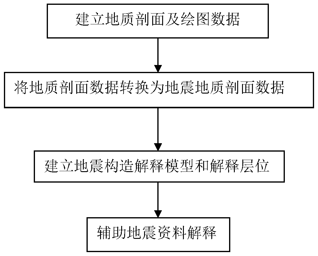
[0062] According to the flow process of the method for auxiliary seismic data interpretation of the present invention (see figure 1 ), formulate work steps, and this embodiment is to assist two seismic data interpretation work related to marine strata in a mountainous two-dimensional seismic work area (taking a certain two-dimensional seismic block in southern mountainous area as an example), these two interpretations The horizons are the Silurian bottom (Ts) and the Permian bottom (Tp).

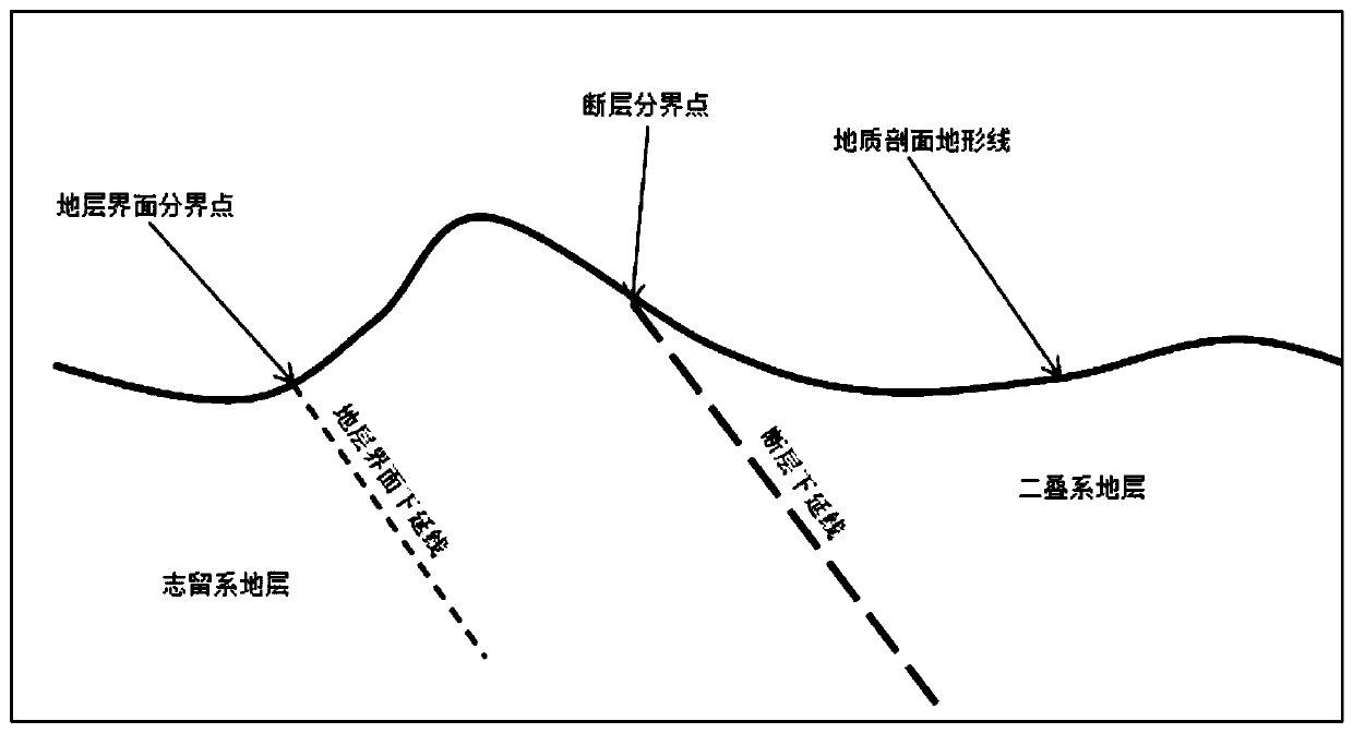
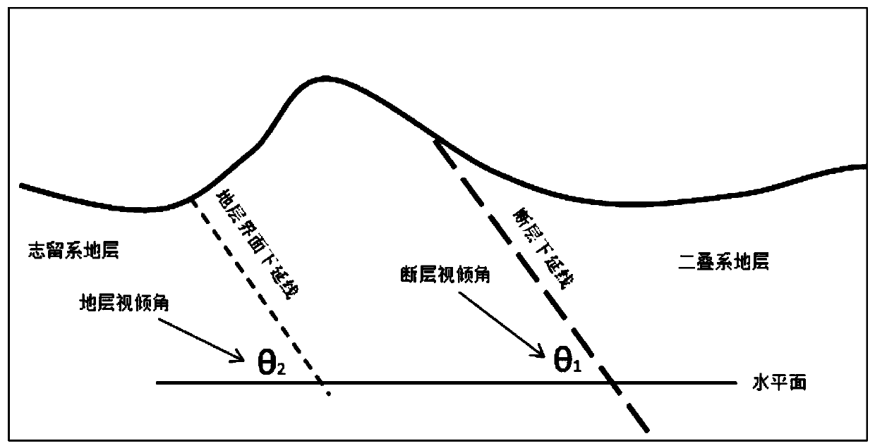
[0063] In step (1), the field geological survey is carried out on the relevant seismic survey line, and the mapping data such as the corresponding geological section and elevation, coordinates, apparent dip angle and inclination of the stratum and fault interface, stratum and fault boundary point, etc. are obtained, such as figure 2 As shown, it is a schematic diagram of the drawing parameters of the geological section in Example 1 of the present invention Figure 1 ,Such as image 3 As s...


PUM


Abstract

The invention discloses a method for helping explain seismic document. The method comprises the steps of (1) building a geological section on a geological section measurement line needed to be explained, and obtaining drawing data of the geological section; and (2) converting a geological section form line onto the geological section to form a seismic geological section form line according to a replacement speed of seismic document processing and coordinate and altitude data of each sampling point on a processing reference surface and the geological section form line, converting an apparent dip angle of a stratum and fault interface on the geological section to a time dip angle on the seismic geological section, downwards extending a length value along a straight line according to a position of a boundary point of the stratum and fault interface on the seismic geological section form line and according to the time dip angle and an inclination direction, implementing artificial explanation on a downward extension line on the seismic section, drawing positions and faults of a seismic geological structure model, and forming the seismic geological section to help explain the seismic document. By the method, the seismic document of a mountain land can be accurately and effectively explained.

Description

technical field [0001] The invention relates to a method for seismic data interpretation, in particular to a method for assisting seismic data interpretation. Background technique [0002] Due to the influence of geological structure, bedrock exposure and other factors in mountainous seismic data, seismic reflection waves are likely to form mutual interference, and the development of a large number of diffracted waves makes seismic imaging difficult, and there are many false events on the seismic section, and these reflection wave events are not accurate. Represents formation reflections. Generally speaking, the imaging of mountainous seismic data is poor, and events are difficult to identify and track. [0003] In recent years, oil exploration has gradually turned to the piedmont, and industrial oil and gas flows have been drilled in some piedmont areas, but some exploration wells have failed. The horizons and structural models of seismic interpretation revealed by drilli...

Claims


Application Information

Patent Timeline
Patent Type & Authority Applications(China)
IPC IPC(8): G01V1/28G01V1/30
CPCG01V1/28G01V1/301
Inventor 蒋裕强周亚东谷一凡付永红蒋增政
Owner SOUTHWEST PETROLEUM UNIV
Why Eureka
Try Eureka