Riverway engineering quality detection method

A technology of engineering quality and river channel, which is applied in surveying devices, surveying and navigation, structured data retrieval, etc. It can solve the problems of inaccurate detection and lack of technical specifications for multi-beam underwater terrain survey

Active Publication Date: 2020-02-04
JIANGSU WATER CONSERVANCY SCI RES INST
View PDF4 Cites 2 Cited by
  • Summary
  • Abstract
  • Description
  • Claims
  • Application Information

AI Technical Summary

Problems solved by technology

[0004] For this reason, the embodiment of the present invention provides a river engineering quality detection method to solve the problem of the lack of specific technical specifications in the multi-beam underwater topographic survey in the prior art, and the inaccurate detection caused by the cross-section comparison method for underwater topographic data processing. exact question

Method used


Image

  • Riverway engineering quality detection method
  • Riverway engineering quality detection method
  • Riverway engineering quality detection method

Examples


Embodiment example 1

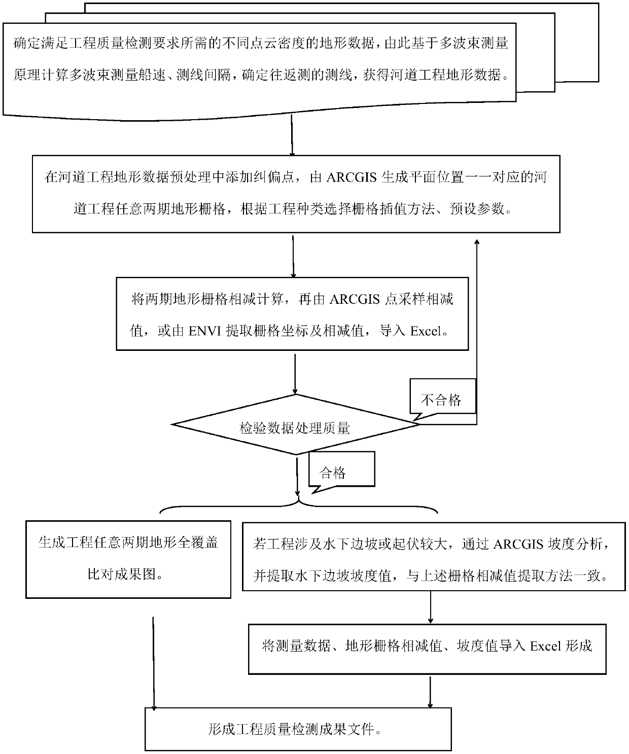
[0156] Take the underwater riprap project in an important section of the Yangtze River in Jiangsu as an example. The local river slope value is between 0° and 45°, with an average value of 30°, see Figure 11 . Considering the difficulty of construction, it is necessary to reasonably classify the slope slope to deal with the random errors in construction. The slope is summarized into three grades of 18°, 27°, and 33° according to the stability of the slope, and the thickening value and reduction value. Measurement data processing is mainly based on ARCGIS, supplemented by Excel, CASS and other software. Calculate the total amount, average value, and specific range of thickening and reduction in the overall area and local area of ​​the project in 2018 compared with 2014. (Calculation process omitted) See Table 7 for topographical changes before and after project implementation, and Table 7 shows topographical changes for a certain two phases of the underwater rock riprap pro...

Embodiment example 2

[0161] Take the local channel sand mining project in the Yangtze Estuary as an example. After processing the underwater topographic survey data in the first and fourth phases of the sand mining project, the local river erosion and deposition changes before and after sand mining are given, and the data of the terrain increase and decrease areas are respectively imported into CASS, as shown in Figure 13-1 , 13-2 shown. The study channel generally presents the erosion and deposition characteristics of "north erosion and south siltation, concave bank erosion and convex bank siltation". Calculate and count the evolution of the riverbed from the full-coverage comparison data 1: Changes in riverbed geographic elevation, see Table 8, Table 8 shows the change in riverbed geographic elevation; data imported into CASS to calculate and count the riverbed evolution 2: Riverbed volume changes, see Table 9, Table 9 shows the channel volume change, unit: 10,000 m 3 .

[0162] Table 8

...


PUM


Abstract

The embodiment of the invention provides a riverway engineering quality detection method, which comprises the steps of determining a survey line interval based on a multi-beam measurement principle, determining whether round-trip measurement and ship speed measurement are needed or not, and obtaining topographic data required by engineering quality detection; adding correction points in terrain data preprocessing, so that the positions of any two stages of engineering terrain grid planes generated by the ARCGIS are in one-to-one correspondence; selecting a corresponding grid interpolation algorithm according to different projects, and subtracting two stages of terrain grids; extracting a subtraction value, namely an elevation change value, and respectively extracting two stages of gradient values; forming original data, elevation change values and slope value table files which are in one-to-one correspondence, and calculating to obtain parameter values required by engineering qualitydetection; and determining the river engineering quality according to engineering standard requirements. A digital model for determining the multi-beam underwater topography measurement method is provided, and the multi-beam measurement technology is more standard; defects existing in section comparison detection are overcome, terrain characteristics are considered to achieve two-stage terrain full-coverage comparison, and data processing is more scientific and efficient.

Description

technical field [0001] The embodiments of the present invention relate to the technical field of river engineering quality inspection, and in particular to a river engineering quality inspection method. Background technique [0002] For the multi-beam measurement method of river engineering topography, there are currently no specific normative requirements for different river engineering. Studies have shown that the multi-beam measurement point cloud data point distance is affected by many factors such as water depth and measurement fan angle. Based on the multi-beam measurement principle, the multi-beam survey line interval, ship speed measurement, and survey line round-trip measurement calculated and determined based on the multi-beam measurement principle are indispensable for the scientificity and accuracy of the river engineering quality inspection results. As for the topographic data processing method of river engineering, the current domestic river engineering design ...

Claims


Application Information

Patent Timeline
Patent Type & Authority Applications(China)
IPC IPC(8): G06T17/05G06Q50/08G06Q10/06G06F16/29G01C7/04
CPCG06T17/05G06F16/29G06Q10/06395G06Q50/08G01C7/04Y02A90/30
Inventor 周广宇朱大栋赵钢谭慧明王茂枚徐毅罗青刘洋王晓松陈楠蔡军高业何敏张治兴王振兵姜果
Owner JIANGSU WATER CONSERVANCY SCI RES INST
Why Eureka
Try Eureka