A Landslide Susceptibility Evaluation Method Based on Spatial Logistic Regression and Geographic Detector

A technology of logistic regression and logistic regression model, applied in the field of risk management of natural disasters, can solve the problems of spatial structure information only considering spatial attribute information, error of landslide susceptibility results, and reduced reliability of susceptibility maps, etc. The effect of improving prediction accuracy

Active Publication Date: 2020-11-10
成都垣景科技有限公司
View PDF5 Cites 0 Cited by
  • Summary
  • Abstract
  • Description
  • Claims
  • Application Information

AI Technical Summary

Problems solved by technology

[0004] The present invention proposes a landslide susceptibility evaluation method based on spatial logistic regression and geographic detectors to solve the problem in the prior art that the results of landslide susceptibility are biased because the spat

Method used


Image

  • A Landslide Susceptibility Evaluation Method Based on Spatial Logistic Regression and Geographic Detector
  • A Landslide Susceptibility Evaluation Method Based on Spatial Logistic Regression and Geographic Detector
  • A Landslide Susceptibility Evaluation Method Based on Spatial Logistic Regression and Geographic Detector

Examples


Embodiment

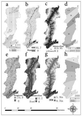
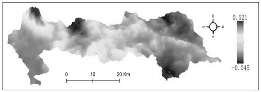
[0032] according to figure 1 , figure 2 Shown flow chart, an invention implementation example of the present invention is as follows:

[0033] (1) Step 1: Extract the slope unit of the area to be evaluated as the basic evaluation unit for landslide susceptibility evaluation, and select the influencing factors of the basic evaluation unit.

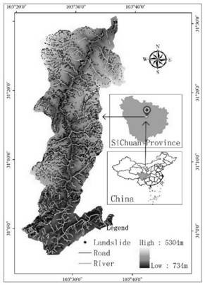
[0034] In this example, the area along the Duwen Highway is selected as the area to be evaluated at east longitude 103°14′~103°45′ and north latitude 30°54′~31°36′, with an area of ​​about 935km 2 From the perspective of topography, the research area gradually rises from southeast to northwest, transitions from middle-low to high mountains, and has large terrain undulations, with relative height differences ranging from 300 to 2500m, and natural disasters such as landslides and mud-rock flows are extremely prone to occur. In this example, based on the 0.5m multi-band remote sensing images of the Pleiades satellite in 2014, the remote sen...


PUM


Abstract

The invention discloses a landslide susceptibility evaluation method based on spatial logistic regression and a geographical detector. The method mainly comprises the following steps: extracting a basic evaluation unit; screening evaluation factors; establishing a spatial logistic regression model; evaluating a spatial logistic regression model. Moreover, the contribution degree of the influence factors in the slope units to the spatial distribution of the landslide is calculated through a geographic detector, the influence factors with the significant contribution degree to the spatial distribution of the landslide are selected as independent variables of the spatial logistic regression model, and then the regression coefficient of the spatial logistic regression model is solved by usingthe test data set. According to the invention, the spatial logistic regression model is established; according to the method, an influence factor with significant contribution degree of landslide spatial distribution is selected as an independent variable, attribute information and spatial structure information of spatial data are utilized, and a spatial autocorrelation effect is used as a potential information source to improve the model, so that the fitting degree and prediction precision of the model are significantly improved.

Description

technical field [0001] The invention relates to the field of risk management of natural disasters, in particular to a landslide susceptibility evaluation method based on spatial logic regression and geographic detectors. Background technique [0002] Because of its huge disaster-causing power, landslides can cause serious losses to people's lives and properties. The evaluation of landslide susceptibility is an important basis and core content of disaster prevention and mitigation. Although a large number of methods have been applied to the previous evaluation of landslide susceptibility, these methods only use the attribute information of geographic data without considering the spatial structure characteristics of geographic data, which makes the evaluation results of landslide susceptibility biased. In addition, the selection of landslide susceptibility evaluation indicators is affected by subjectivity, which limits the reliability of the evaluation results to a certain ext...

Claims


Application Information

Patent Timeline
IPC IPC(8): G06F30/27G06T17/05G06N3/04
CPCG06T17/05
Inventor 杨锦涛靳旭吕波袁野
Owner 成都垣景科技有限公司
Why Eureka
Try Eureka