Fine automatic prediction method and system for atmospheric horizontal visibility with high spatial resolution

A technology with high spatial resolution and horizontal visibility, applied in the field of meteorology, can solve problems such as low spatial resolution, low degree of automation, and poor visibility forecast accuracy

Active Publication Date: 2019-11-19
OCEAN UNIV OF CHINA
View PDF4 Cites 2 Cited by
  • Summary
  • Abstract
  • Description
  • Claims
  • Application Information

AI Technical Summary

Problems solved by technology

[0007] The object of the present invention is to provide a method and system for automatic forecasting of refined atmospheric level visibility with high spatial resolution, so as to overcome the poor accuracy of visibility forecast in the prior art (o...

Method used


Image

  • Fine automatic prediction method and system for atmospheric horizontal visibility with high spatial resolution
  • Fine automatic prediction method and system for atmospheric horizontal visibility with high spatial resolution
  • Fine automatic prediction method and system for atmospheric horizontal visibility with high spatial resolution

Examples


Embodiment 1

[0120] Taking the coastal areas of Fujian as an example, this forecast method is explained in detail:

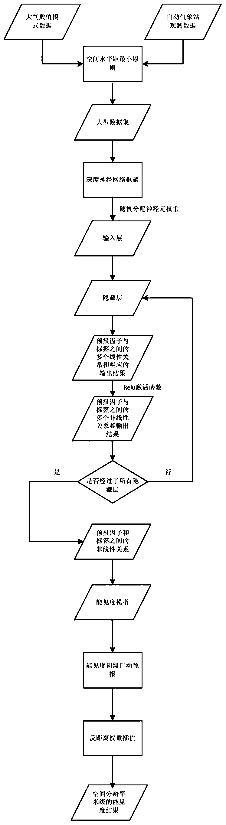
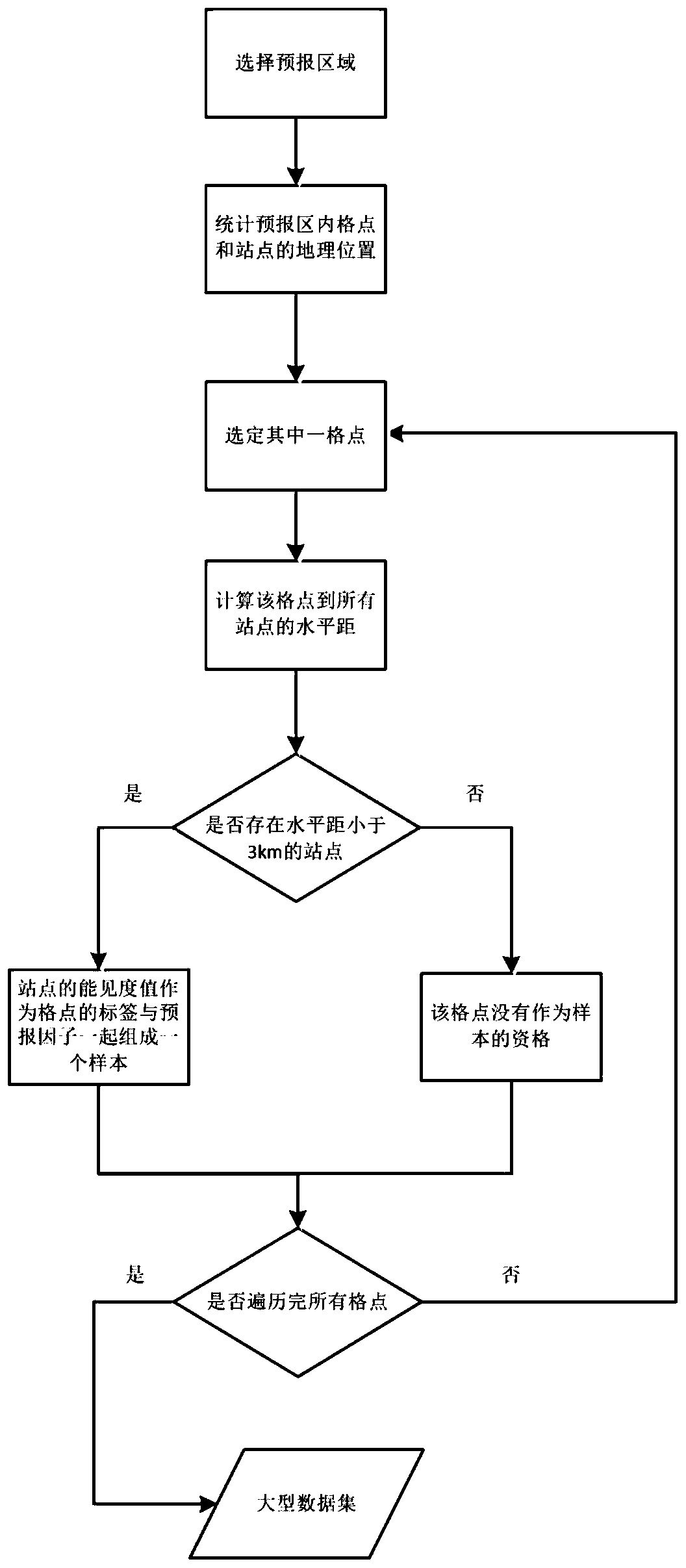
[0121] The target forecast area is defined as the 100km area along the coastline within the boundaries of Fujian Province. The observation data of automatic weather stations and the historical simulation results of WRF model in 2016-2017 were selected. The horizontal spatial resolution of the model is 0.09°×0.09°, and there are 19 automatic meteorological observation stations within 3km horizontal distance from the model grid points. The hourly zonal wind (m / s) at 10 meters above the surface, the meridional wind at 10 meters above the surface (m / s), Temperature (K) at 2 meters above the surface, dew point temperature (K) at 2 meters above the surface, temperature dew point difference (K), relative humidity at 2 meters above the surface, relative humidity on the 925hPa atmospheric isobaric surface, atmosphere The spatial vertical distance (m) between the bottom of the bound...


PUM


Abstract

The invention relates to a fine automatic prediction method and a system for atmospheric horizontal visibility with a high spatial resolution. The fine automatic prediction method comprises steps of comprehensively analyzing and processing atmospheric numerical model data and observation data at an automatic meteorological station, establishing a large data set with the principle of minimum spatial horizontal distance; inputting the data set into a deep neural network framework, processing with a plurality of hidden layers to obtain a nonlinear relationship between a predictor and a tag , continuously adjusting a weight by feedback learning of a deep neural network neuron to train a visibility model that can distinguish overall characteristics of the predictor; and then cooperating with aninterpolation method to obtain a fine prediction of visibility with a high spatial resolution. The fine automatic prediction method effectively solves the problem of poor accuracy of predicting the visibility, lower spatial resolution and lower automation level in the prior art, thus provides a reliable warning for local low-visibility disasters occurred at sea, inland, and ports, and is expectedto become a powerful tool for visibility prediction in the meteorological station.

Description

technical field [0001] The invention belongs to the technical field of meteorology, and in particular relates to a method and system for automatic forecasting of refined atmospheric level visibility with high spatial resolution. Background technique [0002] Visibility is a routine item of meteorological observation, which reflects the degree of atmospheric turbidity. Atmospheric low visibility is usually important and dangerous weather, which seriously affects aviation, navigation and road traffic. According to statistics, more than 80% of aviation accidents and maritime collisions are caused by low visibility. The generation of low visibility is the result of physical, chemical, and radiation processes operating on different spatial and temporal scales. It is believed that complex nonlinear changes of aerosol concentration changes, turbulent mixing, radiation and other complex processes and their changes in short time and small scale are the reasons for the difficulty in...

Claims


Application Information

Patent Timeline
IPC IPC(8): G01W1/10G06K9/62G06N3/04
CPCG01W1/10G06N3/04G06N3/044G06F18/214Y02A90/10
Inventor 李昕蓓张苏平衣立崔丛欣韩美潘宁
Owner OCEAN UNIV OF CHINA
Why Eureka
Try Eureka