Adaptive correction method for intersection error of surveying and mapping satellite
A correction method and self-adaptive technology, applied in the field of optical remote sensing satellites, can solve the problem that the error will approach or even exceed 3.5m, and achieve the effect of increasing the difficulty of development, improving the elevation accuracy, and reducing the accuracy requirements.
- Summary
- Abstract
- Description
- Claims
- Application Information
AI Technical Summary
Problems solved by technology
Method used
Image
Examples
Embodiment
[0046] In the following, the feasibility and high precision of the method of the present invention are verified through the embodiment of the left-right-view stereoscopic image acquired on-orbit.
[0047] 1. Left and right stereo images of satellites in orbit.
[0048] The resolution of WorldView-3 satellite left and right stereo image products is 0.5m (such as figure 2 shown), the image size is 512 pixels*512 pixels, and has its corresponding RPC parameters, which can be obtained by calculating the RPC -1 parameter.
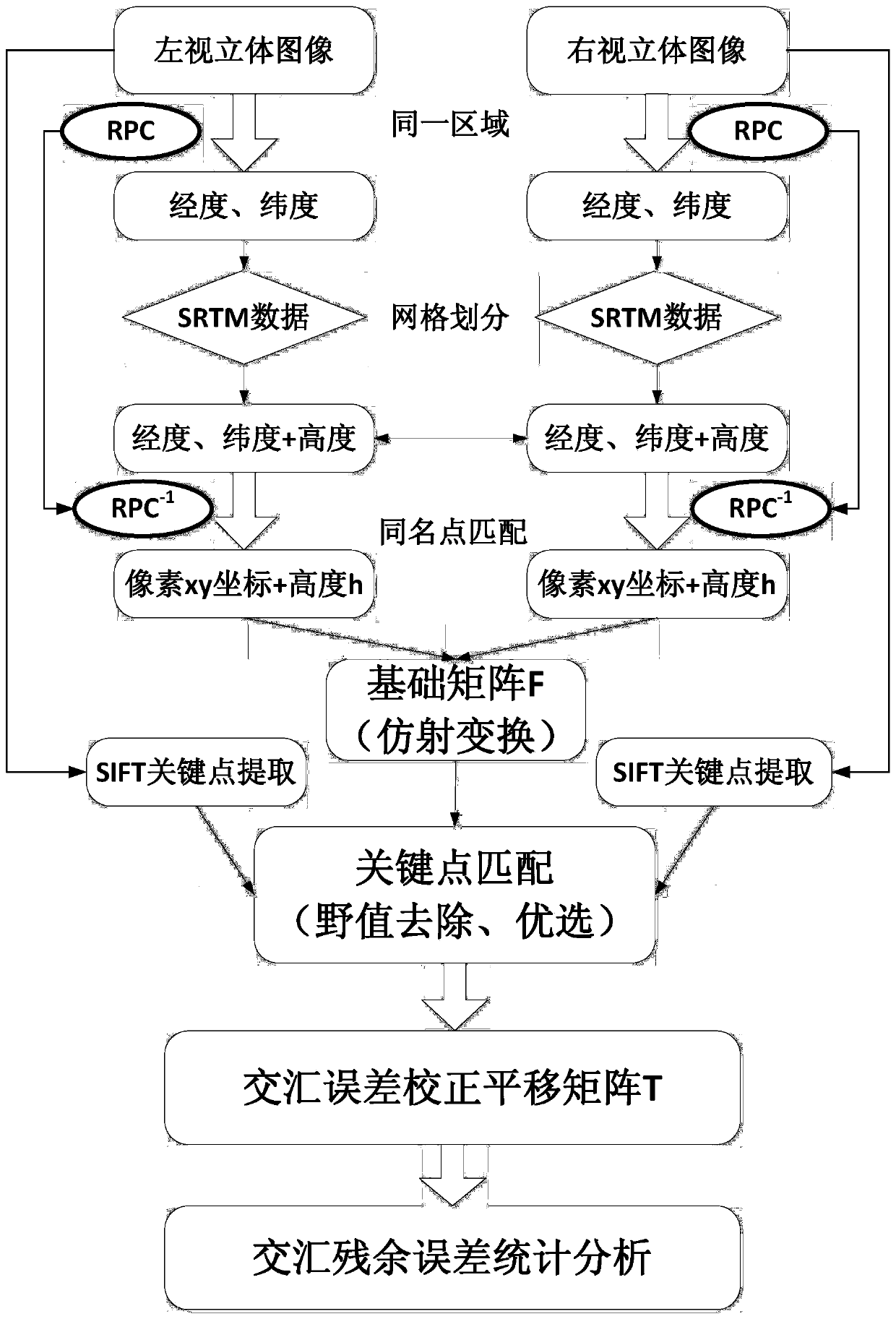
[0049] 2. Calculation of the fundamental matrix F.
[0050] Stereoscopic images through left and right viewing and RPC and RPC -1 Parameters, using SRTM data, through the matching of multiple points with the same name, the affine transformation basic matrix F is calculated as:
[0051]
[0052] 3. Calculation of the translation matrix T.
[0053] A total of 98 points were extracted by SIFT key point matching on the left and right stereoscopic images. Af...
PUM
 Abstract
Description
Claims
Application Information
 - R&D
- Intellectual Property
- Life Sciences
- Materials
- Tech Scout
- Unparalleled Data Quality
- Higher Quality Content
- 60% Fewer Hallucinations
Browse by: Latest US Patents, China's latest patents, Technical Efficacy Thesaurus, Application Domain, Technology Topic, Popular Technical Reports.
© 2025 PatSnap. All rights reserved.Legal|Privacy policy|Modern Slavery Act Transparency Statement|Sitemap|About US| Contact US: help@patsnap.com


