
Single linear array satellite laser combined with high-precision positioning processing method

A processing method and single-line array technology, which are applied in satellite radio beacon positioning systems, radio wave measurement systems, instruments, etc., can solve the lack of research on single-line array satellites and laser data, the difficulty of elevation accuracy, and the difficulty of single-line array satellites. In addition, problems such as difficulty are added to achieve the effect of enhancing data acquisition capabilities, optimizing external orientation elements, and ensuring real-time performance.

Active Publication Date: 2020-12-25
SPACE STAR TECH CO LTD
View PDF2 Cites 0 Cited by
  • Summary
  • Abstract
  • Description
  • Claims
  • Application Information

AI Technical Summary

Problems solved by technology

Under uncontrolled conditions, for multi-line array three-dimensional surveying and mapping satellites (such as Tianhui-1 and Ziyuan-3, etc.), the elevation accuracy is also difficult to meet the requirements, and it is even more difficult for single-line array satellites
Therefore, it is proposed to introduce laser altimetry data into linear array image beam adjustment, but in recent years, the research on the joint processing of linear array image and laser data is mainly for multi-line array surveying and mapping satellites, and for single linear array satellites and Research on laser data is lacking

Method used


Image

  • Single linear array satellite laser combined with high-precision positioning processing method
  • Single linear array satellite laser combined with high-precision positioning processing method
  • Single linear array satellite laser combined with high-precision positioning processing method

Examples


Embodiment Construction

[0028] Hereinafter, the present invention will be described in detail based on the drawings.

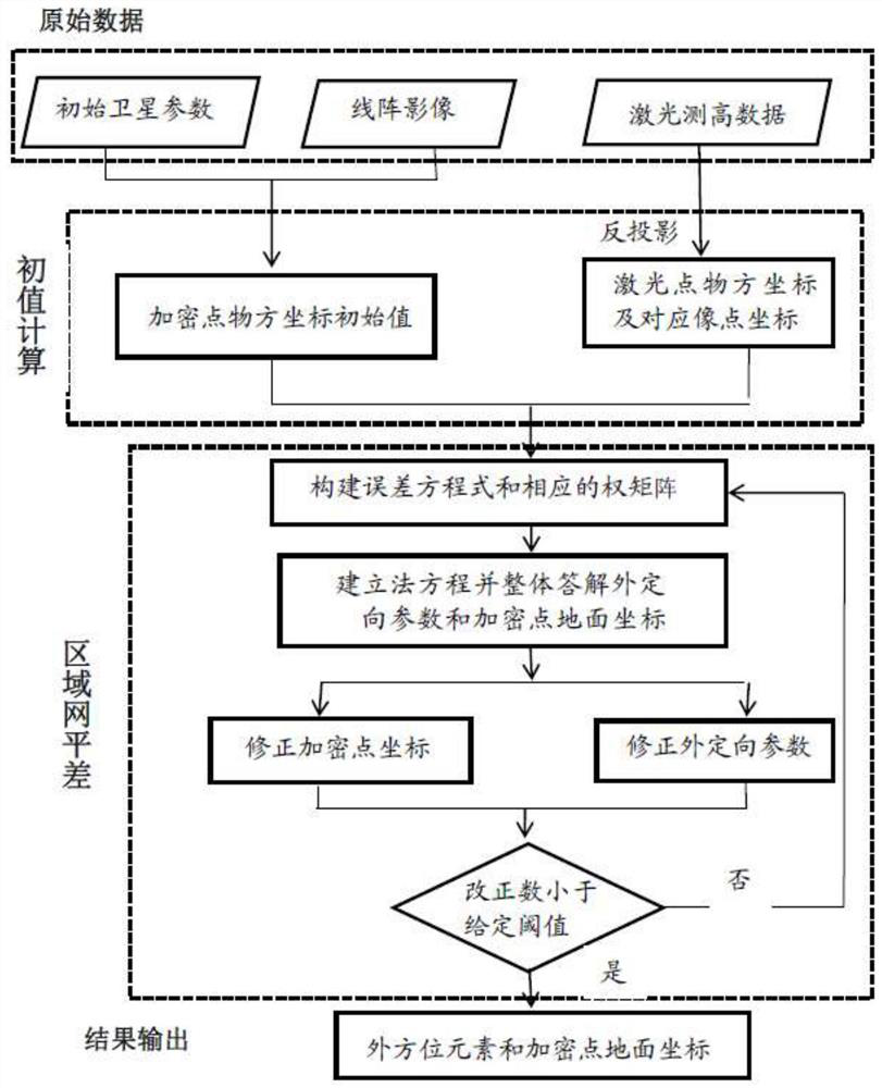
[0029] like figure 1 As shown, the present invention has designed a kind of single linear array satellite laser joint high-precision positioning processing method, and this method comprises the following steps:

[0030] Step (1) Use the single linear array satellite to swing back and forth along the orbit to obtain the stereoscopic image of the ground target at a set intersection angle, and obtain the coordinates of the image square with the same name through stereoscopic image registration, which are used to calculate the initial encryption point in step (2). object space coordinates.

[0031] Step (2) Obtain the initial outer orientation element corresponding to the single-line array image according to the initial parameters of the satellite, and calculate the initial object space coordinates of the encrypted point by using the initial outer orientation element and the single-line...


PUM


Abstract

The invention provides an associated high-precision positioning treatment method for single linear array satellite laser. The method comprises the following steps: using a single linear array satellite to swing along a track, using a set intersection angle to obtain a stereoscopic image of a ground target, and obtaining image space coordinates of corresponding image points through registration ofthe stereoscopic image; using initial orientation parameters and image coordinates of linear array images to calculate pass point initial matter square coordinates; carrying out registration on laser-measured height data and linear array images to obtain image space coordinates corresponding to laser points; constructing an error formula and a corresponding weight matrix; establishing a normal equation, answering image positioning model parameters and the correction numbers of pass point ground coordinates, and amending the image positioning model parameters and the pass point ground coordinates; calculating mean square errors, judging the difference between two mean square errors is smaller than a given limit error, carrying out iteration according to a judgment result, and outputting thecalculated image positioning model parameters and pass point ground coordinates. The data acquisition capacity also can be strengthened while the positioning accuracy is improved, and the timelinessof remote sensing information is guaranteed.

Description

technical field [0001] The invention belongs to the technical field of single-line array satellite communication, and relates to a single-line array satellite laser joint high-precision positioning processing method. Background technique [0002] With the improvement of real-time and accuracy requirements of aerospace remote sensing information, agile satellites have become a type of high-performance satellites that have developed rapidly in the world in recent years. The single line array camera it carries is simple in structure, small in size and light in weight. While realizing high-resolution imaging, with the help of the wide-range and fast attitude maneuvering ability of the whole star, it can obtain no obvious time difference and no radiation by swinging back and forth along the orbit direction. Differential co-orbital stereo pairs. However, compared with multi-line array satellites with fixed rendezvous angles, in order to achieve stereo imaging, single-line array s...

Claims


Application Information

Patent Timeline
Patent Type & Authority Patents(China)
IPC IPC(8): G01S19/48G01S17/87
CPCG01S17/87G01S19/48
Inventor 韩昱朱翔宇刘玉梅贺誉肖卫峰刘炎
Owner SPACE STAR TECH CO LTD
Learn More