Novel data visualization map editing system and method

A map editing and data technology, applied in the field of map editing, can solve the problems of unable to display traffic conditions, lack of data, summary and export, etc., to achieve data visualization, improve production efficiency, and facilitate management

Inactive Publication Date: 2019-09-27
BEIJING UNIV OF POSTS & TELECOMM
View PDF3 Cites 2 Cited by
  • Summary
  • Abstract
  • Description
  • Claims
  • Application Information

AI Technical Summary

Problems solved by technology

[0003] This patent has the following deficiencies: for the detailed information of poor households, it lacks an intuitive way to display it on the map; the map can only display the location of poor households but cannot display more information such as traffic conditions; Mechanism for exporting data summary as a diagram

Method used


Image

  • Novel data visualization map editing system and method
  • Novel data visualization map editing system and method

Examples


Embodiment Construction

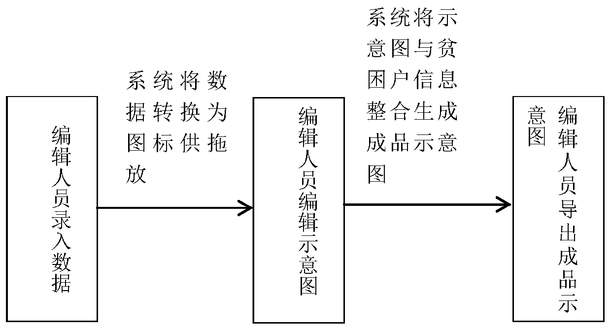
[0042] The present invention will be described in further detail below in conjunction with the accompanying drawings.

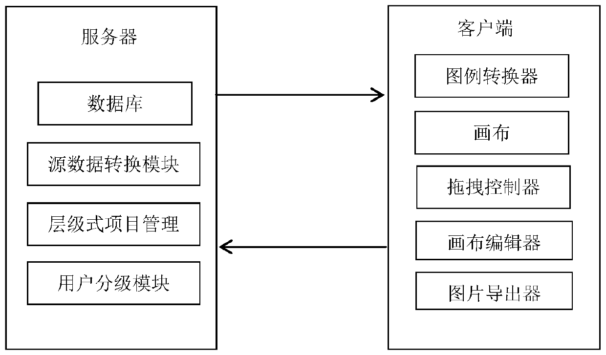
[0043] Such as figure 1 As shown, a new type of data visualization map editing system described in the present invention, the system includes a client and a server; the server is used to provide the client with the data it needs, while receiving and storing the client Edit generated schematic data and complete schematic projects;

[0044] The server end includes a back-end database, a source data conversion module, a hierarchical project management module and a user classification module;

[0045] The client includes a legend converter, a canvas, a drag controller, a canvas editor and an image exporter;

[0046] The back-end database: used to save the source data provided by the user and the schematic data returned by the client;

[0047] The source data conversion module is used to convert the source data provided by the user into data in a format recogni...


PUM


Abstract

The invention relates to a novel data visualization map editing system. The system comprises a client side and a server side. The server side comprises a back-end database, a source data conversion module, a hierarchical project management module and a user grading module; the client includes a legend converter, a canvas, a drag controller, a canvas editor, and a picture deriver. A user imports the source data into a rear-end database, and the source data conversion module identifies the content of the source data, converts the content into a data format which can be identified by the system and provides the data format for the client; when the schematic diagram is edited, the legend converter converts format data which can be identified by the system into icons according to legend information; and finally, the system integrates the edited schematic diagram, the source data and the legend information into a complete schematic diagram item for a user to check and download. According to the invention, data visualization is realized, the working process is concise and clear, and the production efficiency is improved. A set of hierarchical project management and user hierarchical management scheme is provided, and user management is facilitated.

Description

technical field [0001] The invention relates to the technical field of map editing, in particular to a novel data visualization map editing system and method. Background technique [0002] The patent application with the patent number CN108257068A discloses a GIS-based precision poverty alleviation supervision system and method, and the system includes a base layer, a server layer, a poverty alleviation layer and a terminal layer. The basic layer includes account management, data management, map management and coordinate management; account management is used by the supervision department to manage the login account and ID number of poor households when logging in, and to query the user number to understand the information of poor households; Manage the entered information of poor households; map management is used for zooming in and out of the map, dragging the map, and distance measurement; coordinate management can accurately locate the coordinate points of the map where ...

Claims


Application Information

Patent Timeline
Patent Type & Authority Applications(China)
IPC IPC(8): G06F16/904G06F16/9038
CPCG06F16/9038G06F16/904
Inventor 邓智豪孙梓涵董绍辉戴志涛徐萨王景辉
Owner BEIJING UNIV OF POSTS & TELECOMM
Why Eureka
Try Eureka