Visualization method for emergency rescue searching area after aircraft accident

An emergency rescue and aircraft technology, applied in the field of emergency rescue, can solve problems such as low precision, inability to make targeted search and rescue routes, lack of visual images of the crash area, etc., and achieve the effect of improving efficiency and quality

Inactive Publication Date: 2019-08-30
CIVIL AVIATION FLIGHT UNIV OF CHINA +2
View PDF6 Cites 8 Cited by
  • Summary
  • Abstract
  • Description
  • Claims
  • Application Information

AI Technical Summary

Problems solved by technology

[0002] The civil aviation industry is developing rapidly. In 2018, the world's civil aviation transported 1.2 billion passengers, but aviation safety accidents still occur from time to time. In 2018, there were 15 serious fatal air accidents in the world's civil aviation, resulting in a total of 556 deaths. When the area is located in a mountainous area, limited by the topography and the lack of visual images of the wrecked area, it is difficult for rescuers to intuitively understand the topography and topography of the search and rescue area, and it is impossible to formulate

Method used


Image

  • Visualization method for emergency rescue searching area after aircraft accident
  • Visualization method for emergency rescue searching area after aircraft accident
  • Visualization method for emergency rescue searching area after aircraft accident

Examples


specific Embodiment

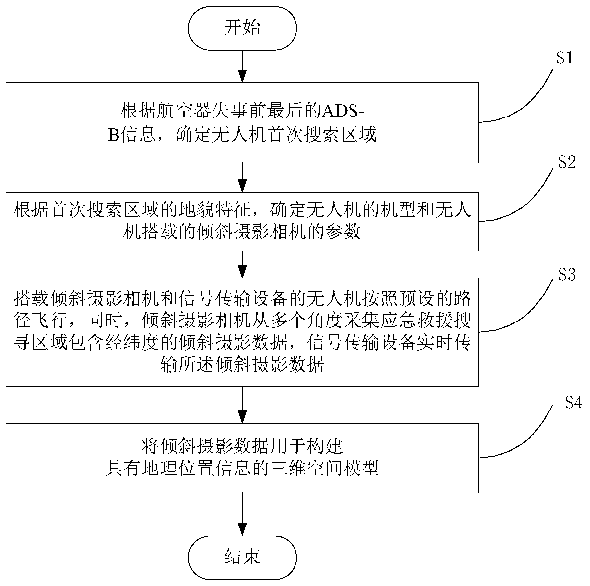
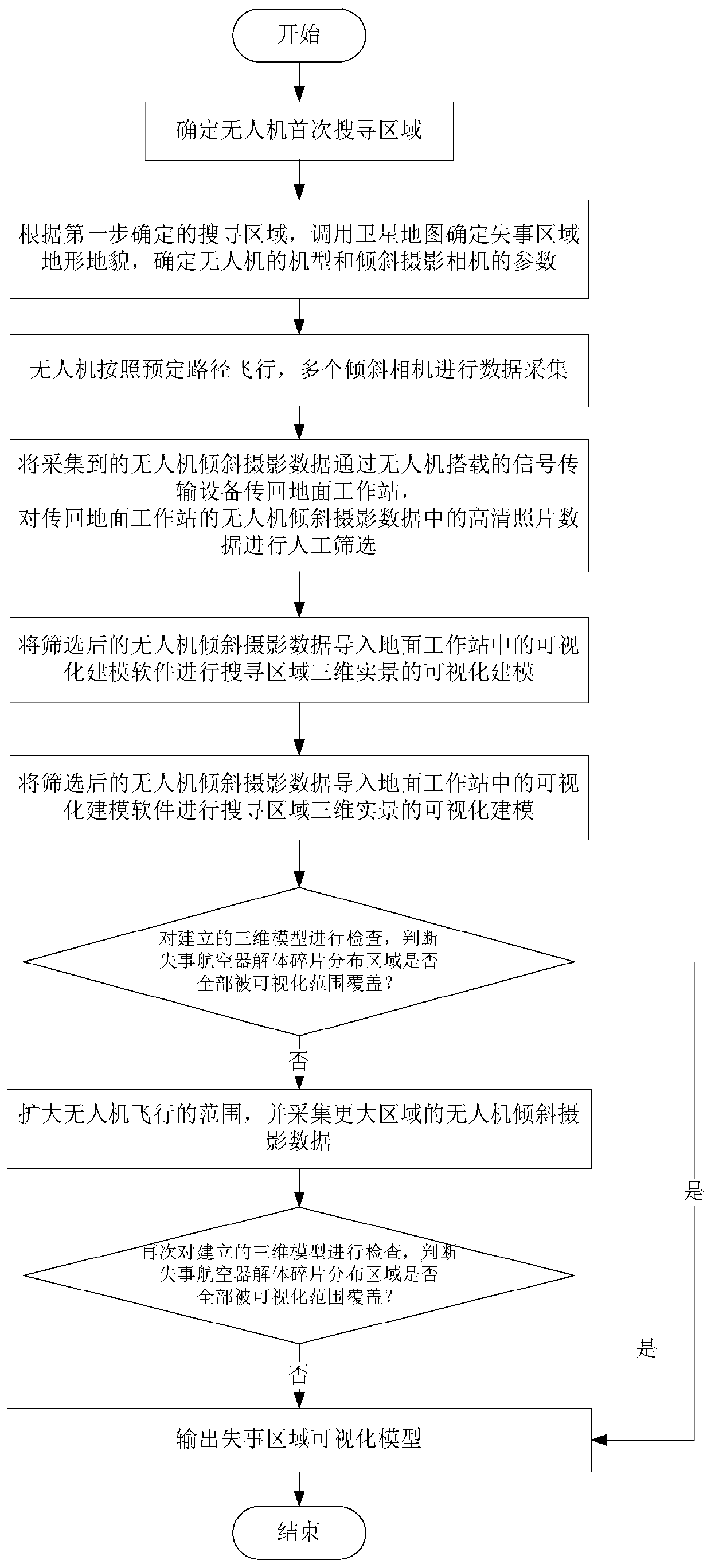
[0055] A flow chart of the method for visualizing the search area for emergency rescue after an aircraft crash according to the present invention is as follows: figure 1 As shown, in this embodiment, as a specific embodiment of the present invention, a flow chart of an emergency rescue search area visualization method after an aircraft crash is as follows figure 2 shown, including the following steps:

[0056] Step 1: According to the pre-accident information provided by the air traffic control department and airlines, determine the first search area for the UAV.

[0057]Determining the search area, which includes the wreckage of the crashed aircraft and the location of all possible survivors, is usually the first step in planning a search. ADS-B, an active monitoring method of the civil aviation system, can be used to extract the final position of the aircraft in the ADS-B information reported by the crashed aircraft (that is, the last longitude and latitude information sen...

Embodiment 2

[0095] In order to more comprehensively simulate the aircraft crash area, this paper comprehensively considers the performance requirements of UAV equipment and different landform conditions, and the search site is an urban building located in an area of ​​Deyang City, Sichuan Province, and a hillside in Chenggong District, Kunming City. The maximum drop is 20 meters.

[0096] The equipment selection comprehensively considers the load capacity, flight performance, and positioning accuracy, and selects the rotor UAV to perform the task. In addition, parameters such as image transmission efficiency, single camera pixels, total camera pixels, and lens focal length of the tilt camera are set. DJI M600 Pro is used as the flight platform, and Jinghang Chuangzhi 3S tilt photography camera is used to obtain tilt photography data. The DJI M600 Pro rotor drone can guarantee the stable flight performance and precise control of the drone during operation. The D-RTK system equipped with i...


PUM


Abstract

The invention discloses a visualization method for an emergency rescue searching area after an aircraft accident in the field of emergency rescue. The method comprises the steps that 1, according to the last ADS-before-aircraft accident, the aircraft is informed; b, determining a first search area of the unmanned aerial vehicle; 2, determining a first search area of the unmanned aerial vehicle according to the final ADS-B information before an aircraft accident;determining the model of the unmanned aerial vehicle and the parameters of the oblique photography camera carried by the unmanned aerial vehicle according to the geomorphological characteristics of the first search area; 3, the unmanned aerial vehicle carrying the oblique photography camera and the signal transmission equipment flies according to a preset path, meanwhile, the oblique photography camera collects oblique photography data, and the signal transmission equipment transmits the oblique photography data in real time; and 4, constructing a three-dimensional space model with geographic position information. The unmanned aerial vehicle and the oblique photography camera are combined, the high-definition camera is carried, multi-angle terrain texture image information of an aircraft accident area is obtained, the limitation that orthographic images can only be shot from the vertical angle is broken through, the shooting angle is enlarged, and a three-dimensional model of the aircraft accident area can be established in real time.

Description

technical field [0001] The invention relates to the field of emergency rescue, in particular to a visualization method for emergency rescue search areas after an aircraft crash. Background technique [0002] The civil aviation industry is developing rapidly. In 2018, the world's civil aviation transported 1.2 billion passengers, but aviation safety accidents still occur from time to time. In 2018, there were 15 serious fatal air accidents in the world's civil aviation, resulting in a total of 556 deaths. When the area is located in a mountainous area, limited by the topography and the lack of visual images of the wrecked area, it is difficult for rescuers to intuitively understand the topography and topography of the search and rescue area, and it is impossible to formulate targeted search and rescue routes, which brings great difficulties to the development of emergency rescue operations. inconvenient. [0003] The existing technology mainly uses high-resolution satellite ...

Claims


Application Information

Patent Timeline
IPC IPC(8): G06T17/05B64D47/00
CPCB64D47/00G06T17/05
Inventor 潘卫军刘铠源宋歌王玄王润东左青海
Owner CIVIL AVIATION FLIGHT UNIV OF CHINA
Why Eureka
Try Eureka