Drone-based call navigation system and method

A navigation system and call system technology, applied in radio wave measurement system, satellite radio beacon positioning system, navigation through speed/acceleration measurement, etc. Problems found or not found in time

Pending Publication Date: 2019-08-23
林奎靖
View PDF5 Cites 1 Cited by
  • Summary
  • Abstract
  • Description
  • Claims
  • Application Information

AI Technical Summary

Problems solved by technology

[0004] In order to solve the problem that tourists often lose their way when visiting scenic spots with complex terrain or large area, or tourists still don’t know how to get to their destination after checking the landmark signs
For large-scale natural scenic spots, although a monitoring network has been established, it is still difficult to detect the danger of passengers in a timely manner and take rescue actions. The efficiency of manual inspection and monitoring for rescue is very low, and it is prone to undetected or untimely detection and other shortcomings, the present invention provides a call navigation system and method based on unmanned aerial vehicles

Method used


Image

  • Drone-based call navigation system and method
  • Drone-based call navigation system and method
  • Drone-based call navigation system and method

Examples


Embodiment Construction

[0024] The technical solution in the present invention will be clearly and completely described below in conjunction with the drawings in the embodiments of the present invention. Obviously, the described embodiments are only part of the embodiments of the present invention, not all of them.

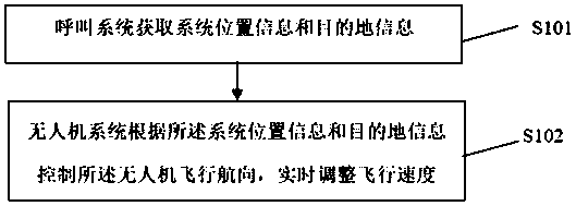
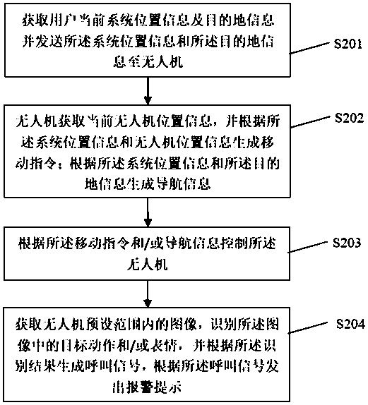
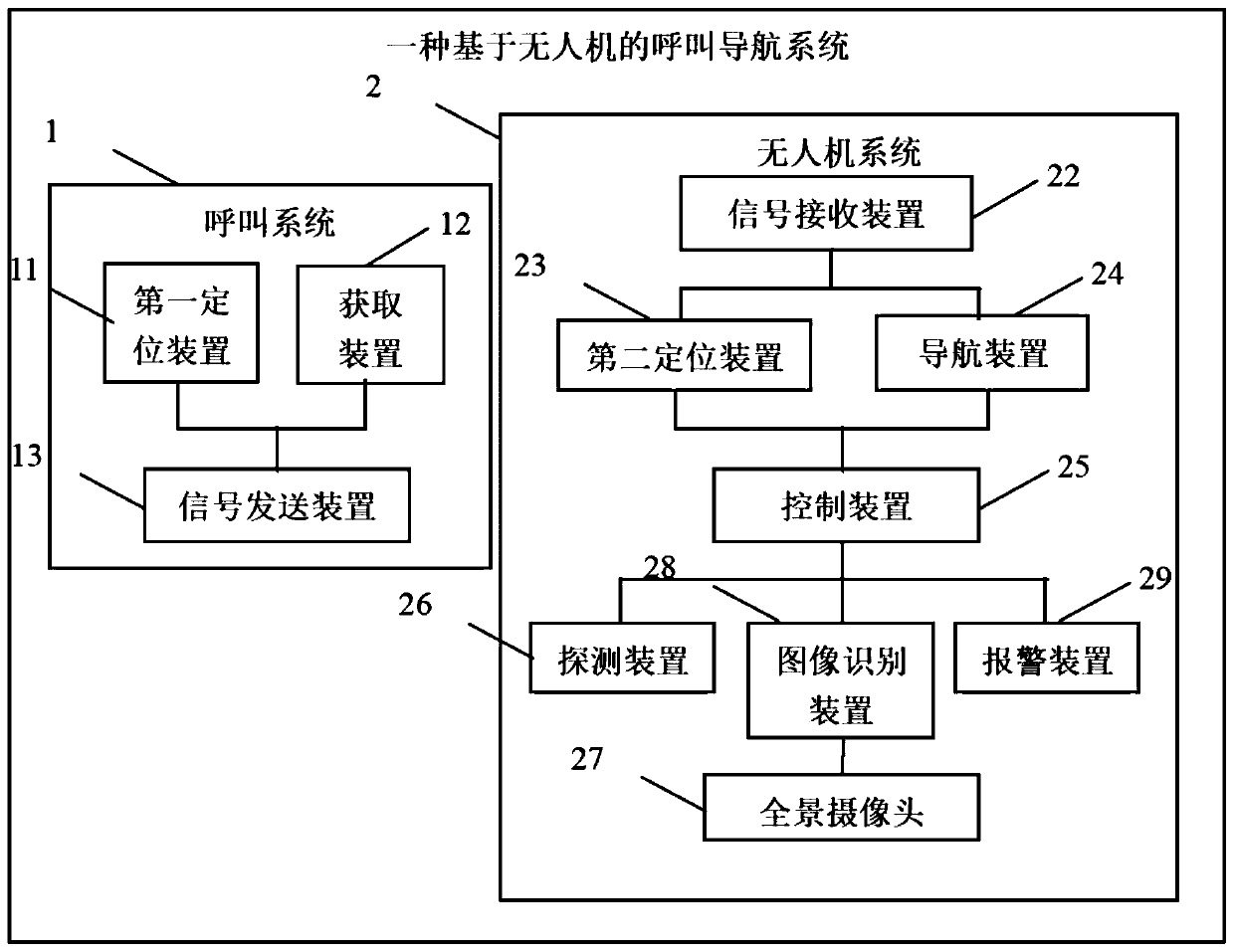
[0025] The embodiment of the present invention discloses a call navigation system based on unmanned aerial vehicle, the schematic diagram of the system is as follows figure 1 As shown, the system includes a calling system 1 and an unmanned aerial vehicle system 2;

[0026] The call system 1 includes a first positioning device 11, an acquisition device 12 and a signal transmission device 13; the first positioning device 11 and the acquisition device 12 are respectively connected to the signal transmission device 13; the first positioning device The device 11 is used to obtain the current system position information; the obtaining device 12 is used to obtain the destination information, an...


PUM


Abstract

The invention belongs to the technical field of drones, and particularly relates to a drone-based call navigation system. The system comprises a call system and a drone system, wherein the call systemcomprises a first positioning device, an acquisition device and a signal transmitting device; the drone system comprises a drone main body and a signal receiving device, a second positioning device,a navigation device and a control device arranged on the drone main body frame; and the control device is used for controlling the flight direction of the drone according to the real-time data of thesecond positioning device and / or the navigation device and adjusting the flight speed in real time. By adopting the drone-based call navigation system, a timely response can be given to the call and navigation requirements of a tourist, an injured tourist in a scenic spot can be timely found out, an alarm is given, and timely rescue by the staff is facilitated.

Description

technical field [0001] The invention belongs to the technical field of drones, and in particular relates to a call navigation system and method based on drones. Background technique [0002] With the rapid development of UAV technology, its application fields are becoming more and more extensive, such as in water quality sampling, air quality sampling, agricultural plant protection, military, aerial photography, survey, mapping, police, urban management, meteorology, electricity, emergency rescue and disaster relief There are applications in other fields. UAV aerial photography technology can be widely used in national ecological environment protection, mineral resource exploration, marine environment monitoring, land use investigation, water resources development, crop growth monitoring and yield estimation, agricultural operations, natural disaster monitoring and evaluation, urban planning and municipal administration Forest management, forest pest protection and monitori...

Claims


Application Information

Patent Timeline
IPC IPC(8): G01C21/12G01V9/00G01S19/42G06K9/00
CPCG01C21/12G01V9/00G01S19/42G06V40/174G06V40/20
Inventor 林奎靖
Owner 林奎靖
Why Eureka
Try Eureka