Semantic stereo reconstruction method of remote sensing image

A remote sensing image and stereo reconstruction technology, applied in the field of image processing, can solve the problem of large color difference, and achieve the effect of improving parallax precision, improving accuracy, and solving the problem of wrong matching.

Active Publication Date: 2019-08-09
XIDIAN UNIV
View PDF8 Cites 13 Cited by
  • Summary
  • Abstract
  • Description
  • Claims
  • Application Information

AI Technical Summary

Problems solved by technology

However, this method requires a large color difference for different objects in the image, so it is not suitable for different categories of remote sensing data, such as trees and grass, viaducts and roads, etc.

Method used


Image

  • Semantic stereo reconstruction method of remote sensing image
  • Semantic stereo reconstruction method of remote sensing image
  • Semantic stereo reconstruction method of remote sensing image

Examples


Embodiment Construction

[0025] The semantic segmentation network framework of this example is Tensorflow-gpu1.4.0, and the disparity estimation network framework is Pytorch0.4.1.

[0026] The present invention is described in detail below in conjunction with accompanying drawing:

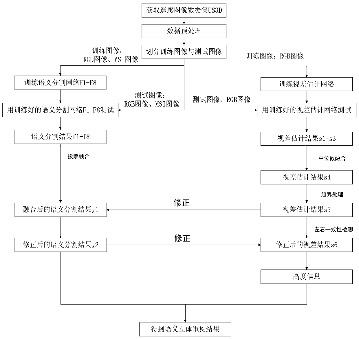
[0027] refer to figure 1 , the implementation steps of the present invention are as follows:

[0028] Step 1: Obtain the remote sensing image dataset US3D.

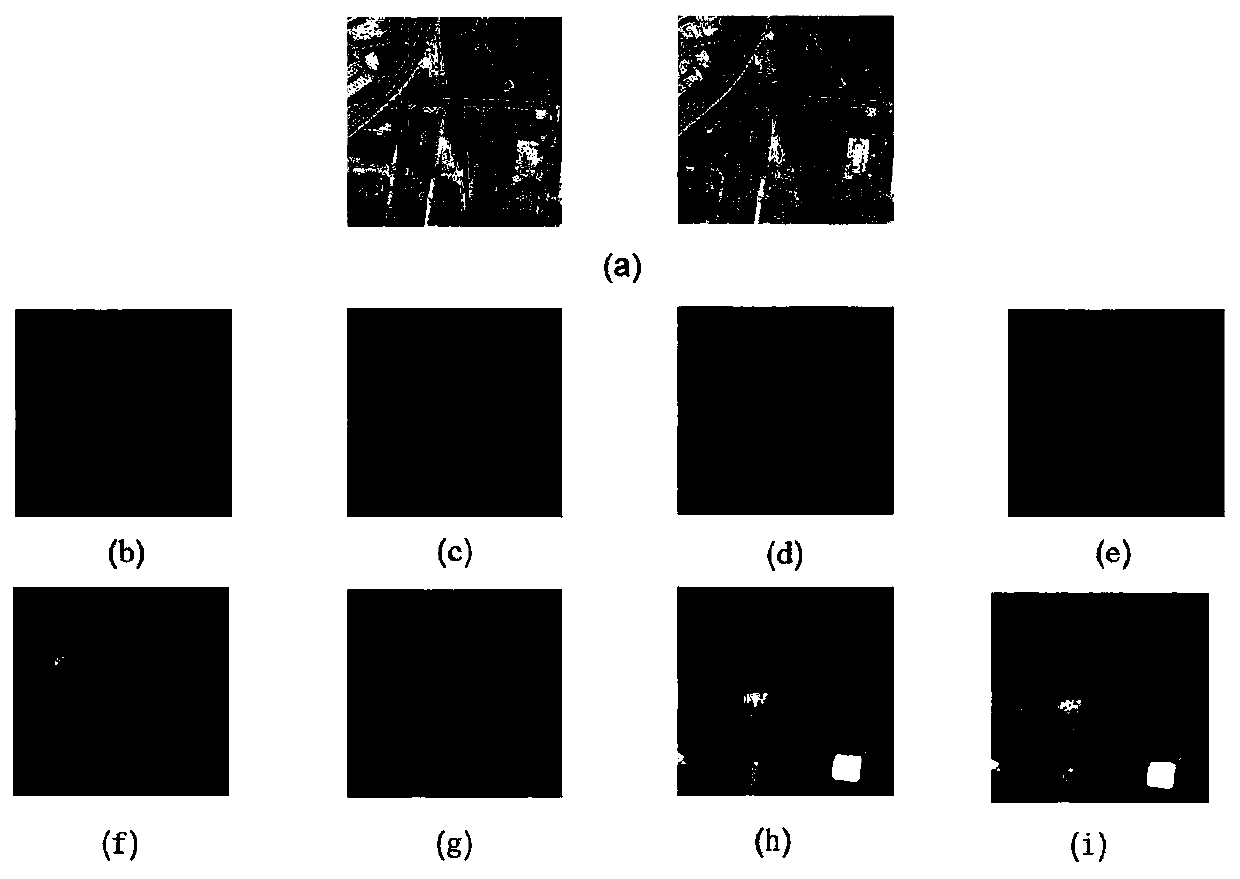
[0029] This remote sensing image dataset contains remote sensing images and their semantic segmentation labels. The resolution of remote sensing images is 1024×1024, and the image types include color RGB images, such as image 3 As shown in (a), and the eight-channel multispectral image MSI, each type of remote sensing image contains epipolar-corrected left and right image pairs, and the semantic segmentation labels include: building, ground, high vegetation, elevated road and water. .

[0030] Step 2: Data preprocessing of remote sensing images in sequence.

[0...


PUM


Abstract

The invention discloses a semantic stereo reconstruction method for a remote sensing image, and mainly solves the problem of low semantic three-dimensional reconstruction precision caused by ignoringrelated information of semantic segmentation and parallax estimation in the prior art. According to the implementation scheme, firstly, experimental data are preprocessed; a semantic segmentation network and a parallax estimation network are trained by using the training data; the trained network is tested on the test image, and test results of different frequency band information are fused to obtain a fused semantic segmentation result and a fused parallax result; the error correction module is used for assisting each other to correct the error part of the opposite side; and the disparity information is calculated to obtain height information, and the semantic segmentation result is combined with the height information to obtain a semantic three-dimensional reconstruction result of the image. According to the method, the proportion of small samples is improved, the influence of data on the network is balanced, the semantic information and the parallax result are fused with each other,the accuracy of semantic three-dimensional reconstruction of the remote sensing image is improved, and the method can be used for urban scene three-dimensional reconstruction.

Description

technical field [0001] The invention belongs to the technical field of image processing, and further relates to a semantic three-dimensional reconstruction method of remote sensing images, which can be used for three-dimensional reconstruction of urban scenes. Background technique [0002] Stereoscopic reconstruction has received increasing attention in the field of computer vision because the perception of the 3D structure of objects can help improve the understanding of real scenes. Disparity estimation is a basic problem in stereo vision, and disparity estimation is used to obtain image depth information. The effectiveness of image feature extraction will directly affect the accuracy of disparity prediction results, so there are more and more researches on deep learning methods in this area. Remote sensing data are increasingly used, however, stereo matching of paired images remains a challenging problem due to the significant appearance differences of remote sensing ima...

Claims


Application Information

Patent Timeline
Patent Type & Authority Applications(China)
IPC IPC(8): G06K9/00G06K9/34G06K9/62
CPCG06V20/13G06V10/267G06F18/22G06F18/241G06F18/214
Inventor 焦李成冯志玺马睿妍高艳洁杨育婷张丹李玲玲郭雨薇
Owner XIDIAN UNIV
Why Eureka
Try Eureka