Unmanned aerial vehicle positioning method based on a cooperative two-dimensional code of a virtual simulation environment

A technology of virtual simulation and positioning method, applied in the field of visual navigation, which can solve problems such as inconsistent camera positioning requirements, and achieve rapid results

Active Publication Date: 2019-04-19
NO 20 RES INST OF CHINA ELECTRONICS TECH GRP
View PDF10 Cites 18 Cited by
  • Summary
  • Abstract
  • Description
  • Claims
  • Application Information

AI Technical Summary

Problems solved by technology

Although the AprilTag system supports positioning, its positioning method is based on the camera coordinate sy

Method used


Image

  • Unmanned aerial vehicle positioning method based on a cooperative two-dimensional code of a virtual simulation environment
  • Unmanned aerial vehicle positioning method based on a cooperative two-dimensional code of a virtual simulation environment
  • Unmanned aerial vehicle positioning method based on a cooperative two-dimensional code of a virtual simulation environment

Examples


Embodiment Construction

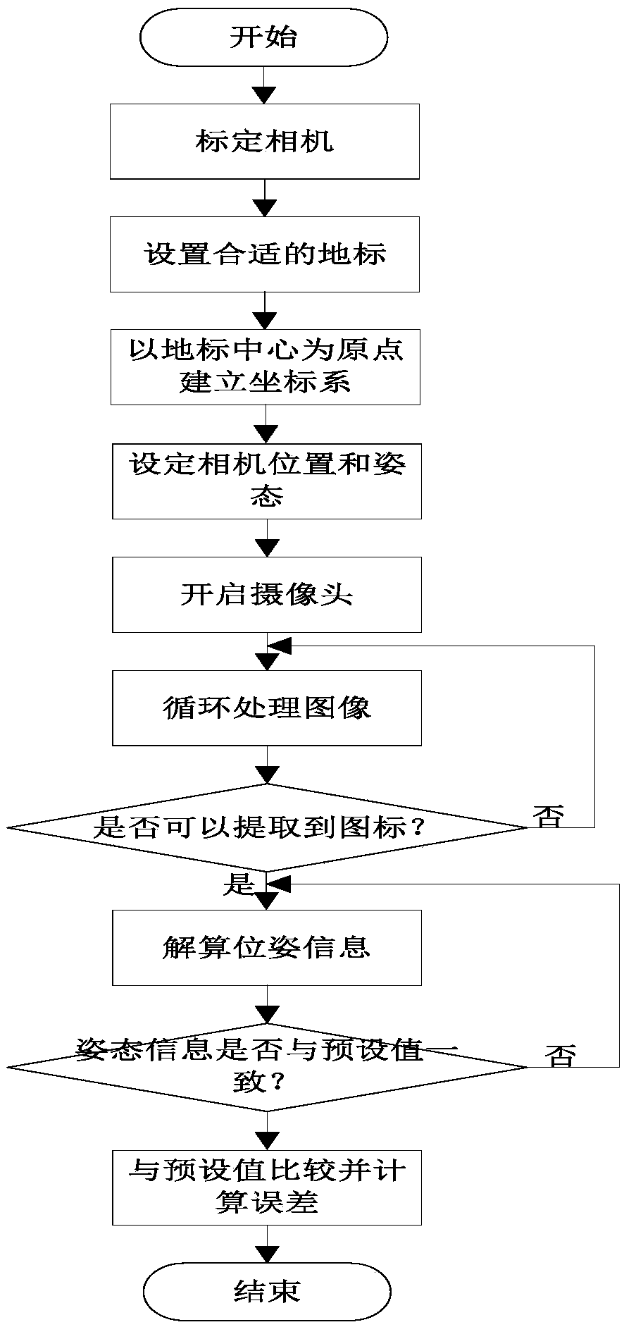
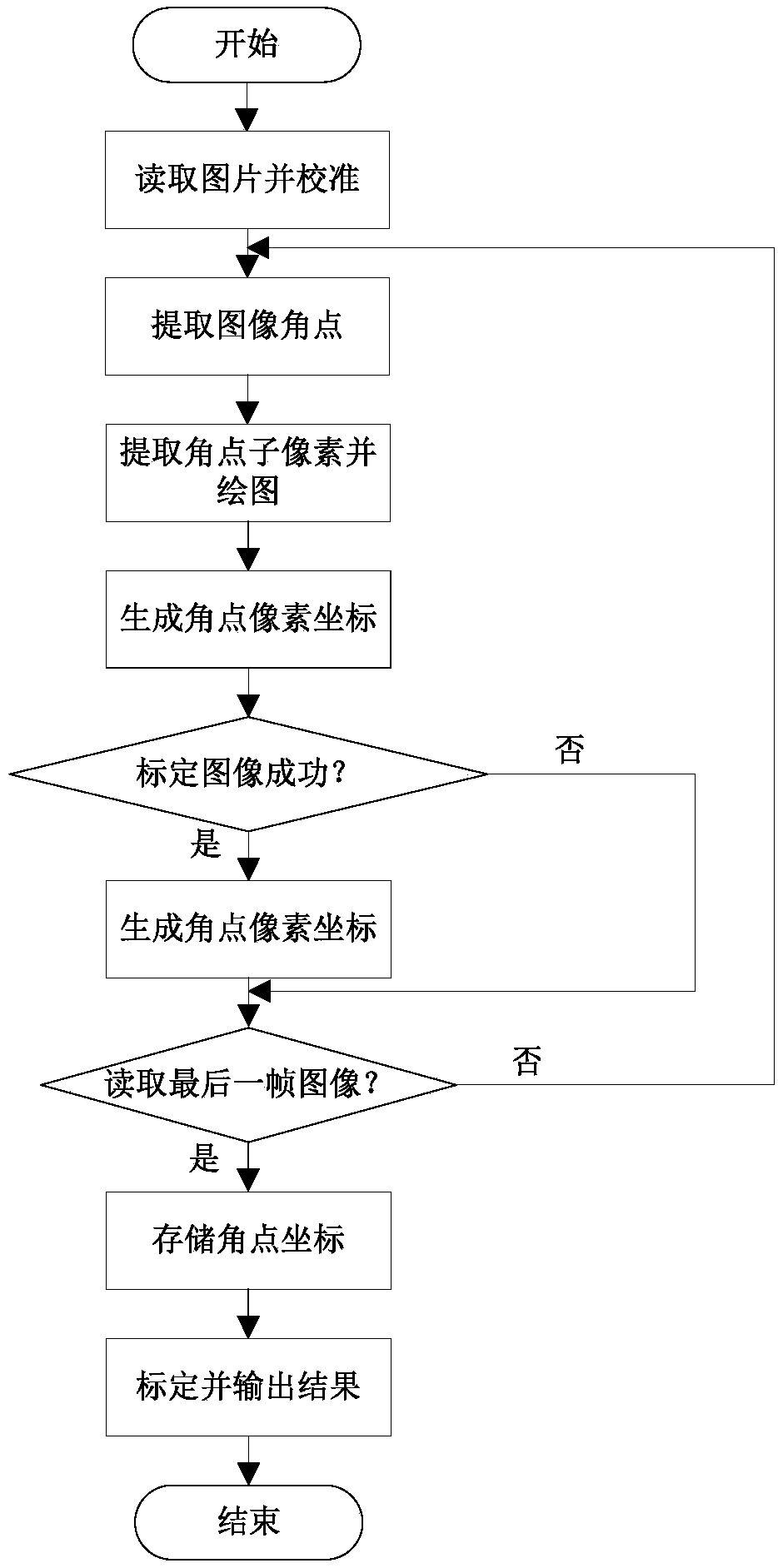
[0020] The present invention will be further described below in conjunction with the accompanying drawings and embodiments, and the present invention includes but not limited to the following embodiments.

[0021] The invention solves the positioning problem of the rotor UAV in a complex flight environment by obtaining the cooperative two-dimensional code image in the environment to solve the position parameters of the UAV and verify the availability of the algorithm in the virtual environment.

[0022] The main task of visual navigation and positioning is to map the 3D camera coordinate system to the world coordinate system according to the matching results between the scene pixels. The basic process can be simplified as how to transform the scene plane coordinates into inertial coordinates, and this process can be carried out by the following formula describe:

[0023]

[0024] Among them, u and v are scene plane coordinates, x w 、y w ,z w Inertial coordinates are prov...


PUM


Abstract

The invention provides an unmanned aerial vehicle positioning method based on a cooperative two-dimensional code of a virtual simulation environment, and the method comprises the steps: placing a checkerboard in a virtual scene, carrying out the calibration of a camera, and obtaining the parameters of the virtual camera; Identifying the AprilTag two-dimensional code in the scene, accurately positioning the unmanned aerial vehicle through the AprilTag two-dimensional code, and verifying the calibration accuracy of the camera and the feasibility of the positioning and attitude determination algorithm based on the AprilTag two-dimensional code in the virtual scene. In the virtual scene, the present invention places a checkerboard grid, uses a coordinate system conversion relationship to obtain virtual camera parameters, and calibrates the camera, and provides a camera internal reference for the drone visual navigation verification algorithm in the virtual scene. the problem that the virtual camera internal parameter cannot be acquired is solved, the calibrated camera parameters and the AprilTag two-dimensional code positioning algorithm are used for solving the position parameters ofthe camera, and the problem of rapid and robust positioning of the unmanned aerial vehicle in a complex environment is solved.

Description

technical field [0001] The invention relates to a positioning method for an unmanned aerial vehicle, which belongs to the field of visual navigation. Background technique [0002] In recent years, the capabilities of UAV systems have been continuously improved, and they have emerged in military and civilian fields such as urban anti-terrorism reconnaissance, disaster monitoring, logistics distribution, and traffic guidance, and their application prospects are particularly broad. UAV positioning is a necessary link for UAVs to perform dynamic tasks, and it is also an important manifestation of UAVs' autonomous capabilities. Aiming at the application requirements of urban buildings / forests / indoor weak GPS (satellite navigation) combat areas and pseudo-GPS environments, in-depth research on UAV positioning methods without GPS dependence, visual navigation technology has high autonomy, passive, low Features such as low cost have been successfully applied in recent years. [00...

Claims


Application Information

Patent Timeline
IPC IPC(8): G06T7/80
CPCG06T7/80G06T2207/30244Y02T10/40
Inventor 高嘉瑜李斌李阳景鑫
Owner NO 20 RES INST OF CHINA ELECTRONICS TECH GRP
Why Eureka
Try Eureka