Multi-data-source roadbed monitoring system and multi-data-source roadbed monitoring evaluation method for saline soil regions

A multi-data source and monitoring system technology, applied in the field of geotechnical engineering, can solve problems such as inability to perform system monitoring and evaluation

Active Publication Date: 2019-04-19
LANZHOU UNIVERSITY
View PDF4 Cites 2 Cited by
  • Summary
  • Abstract
  • Description
  • Claims
  • Application Information

AI Technical Summary

Problems solved by technology

[0006] The purpose of the present invention is to provide a multi-data source saline soil subgrade monitoring system and its monitoring and evaluation method, aiming to solve the problem of road surface muddying, subgrade settlement and pavement problems caused by the prior art in the above background technology after long-term operation of roads in saline soil areas. The cause of cracking and other diseases cannot be systematically monitored and evaluated

Method used


Image

  • Multi-data-source roadbed monitoring system and multi-data-source roadbed monitoring evaluation method for saline soil regions
  • Multi-data-source roadbed monitoring system and multi-data-source roadbed monitoring evaluation method for saline soil regions
  • Multi-data-source roadbed monitoring system and multi-data-source roadbed monitoring evaluation method for saline soil regions

Examples


Embodiment Construction

[0044] In order to make the object, technical solution and advantages of the present invention clearer, the present invention will be further described in detail below in conjunction with the accompanying drawings and embodiments. It should be understood that the specific embodiments described here are only used to explain the present invention, not to limit the present invention.

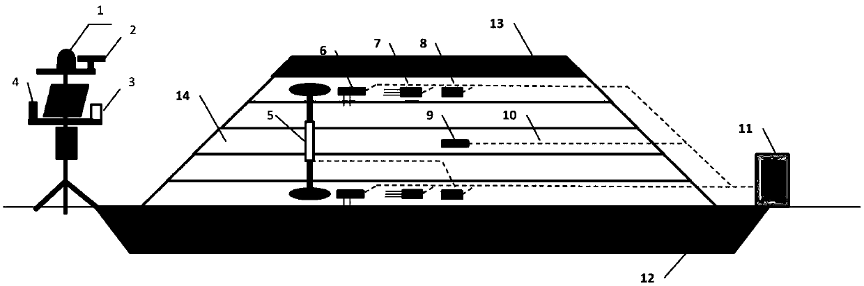
[0045] refer to figure 1 , a subgrade monitoring system in saline soil area with multiple data sources, including a micro-weather station installed within the scope of the subgrade land, the micro-weather station includes a thermal radiation sensor 1, a wind speed sensor 2, a rain gauge 3 and a relative humidity meter 4. Displacement gauge 5, salinity sensor 6, volumetric water content sensor 7, accelerometer 8, and earth pressure sensor 9 are buried in the roadbed in layers along the depth direction of the roadbed. The earth pressure sensor 9 is a double-membrane earth pressure sensor. Bury a sal...


PUM


Abstract

The invention discloses a multi-data-source roadbed monitoring system for saline soil regions. The system comprises a micro weather station. The micro weather station mounted in a roadbed site comprises a heat radiation sensor, a wind speed sensor, a rain gauge and a relative humidity meter. A displacement meter, a salt sensor, a volume and moisture content sensor, an accelerometer and an earth pressure sensor, which are buried in a roadbed along the depth direction of the roadbed in a layered mode, are electrically connected with a data acquisition and transmission device mounted in the roadbed site through connection lines. The multi-data-source roadbed monitoring system has the advantages that multi-data sources of the roadbed are acquired by the micro weather station and the data acquisition and transmission device, the acquired data are converted into the soil dynamic modulus, net evaporation rate, salt content and roadbed cumulative deformation before correlation analysis, damageto roads in the saline soil regions, such as pavement frost heaving, roadbed settlement and pavement cracking, are monitored, and the evaluation basis is provided for causes and improvement methods of the damage to roadbeds.

Description

technical field [0001] The invention belongs to the technical field of geotechnical engineering in transportation engineering and civil engineering, and in particular relates to a multi-data source saline soil subgrade monitoring system and a monitoring and evaluation method thereof. Background technique [0002] A large number of infrastructures built and under construction in Northwest my country are located in inland saline soil areas, and the groundwater is brine with high salinity, mainly consisting of chloride salts and sulfates. In the construction of Lanzhou-Xinjiang Railway, Dunhuang Airport, Lanzhou New District Airport, Xinjiang Hami-Lop Nur Railway, Gansu National Highway 215 and Qinghai National Highway 315, a large number of reports have been made on the salt swelling and subsidence of foundations and subgrades. At present, the treatment of subgrade in saline soil areas mostly adopts the method of replacing the road bed with coarse granular materials, or laying...

Claims


Application Information

Patent Timeline
Patent Type & Authority Applications(China)
IPC IPC(8): E02D1/00E01C3/00G01W1/02G01N33/42G01L5/00G01P15/00
CPCE01C3/00E02D1/00G01L5/0028G01N33/42G01P15/00G01W1/02
Inventor 张彤炜张兴军张晓军栾纪昊邓永锋
Owner LANZHOU UNIVERSITY
Why Eureka
Try Eureka