A method and system for correcting SAR image geometric positioning parameters
A technology of geometric positioning and parameter correction, which is applied in the direction of radio wave measurement systems, instruments, and measuring devices, can solve the problems of slow processing speed and difficult realization of areas with sparse terrain textures, and achieve the effect of improving the accuracy of geometric positioning
- Summary
- Abstract
- Description
- Claims
- Application Information
AI Technical Summary
Problems solved by technology
Method used
Image
Examples
Embodiment 1
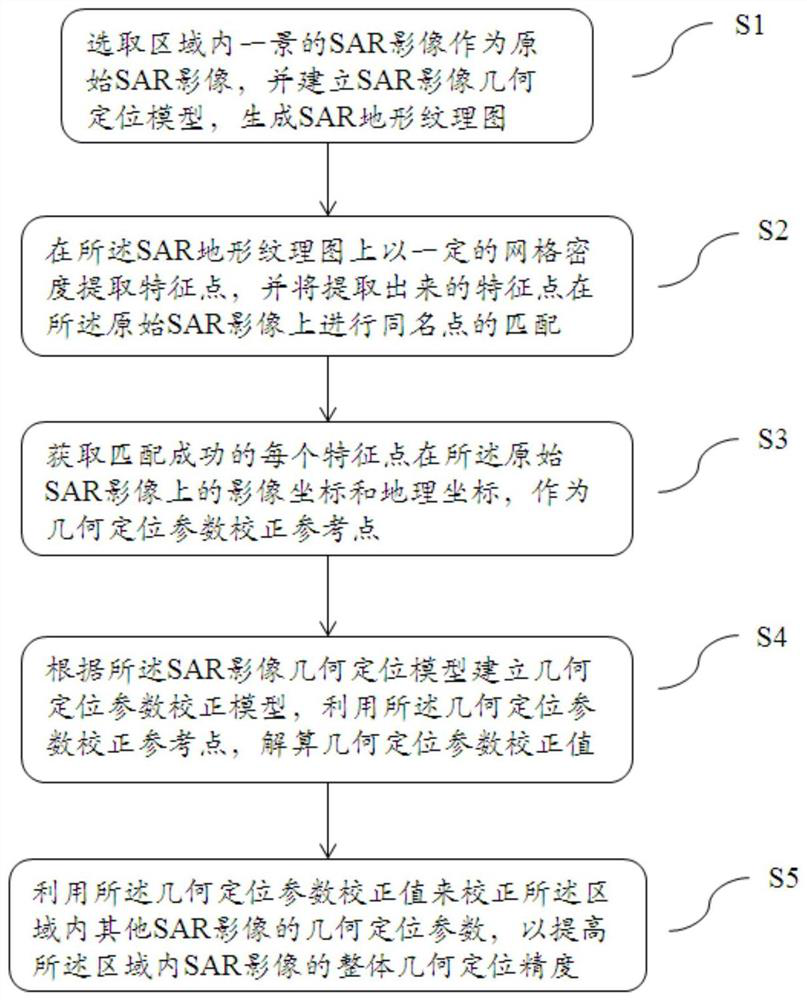
[0046] Such as figure 1 Shown is a structural block diagram of a method for correcting SAR image geometric positioning parameters in this embodiment. The SAR image geometric positioning parameter correction method disclosed in this embodiment includes:
[0047] Select a SAR image of a scene in the area as the original SAR image, and establish a SAR image geometric positioning model to generate a SAR terrain texture map;
[0048] Extracting feature points with a certain grid density on the SAR terrain texture map, and matching the extracted feature points with points of the same name on the original SAR image;
[0049] Obtain the image coordinates and geographic coordinates of each feature point that is successfully matched on the original SAR image, and obtain the geometric positioning parameter correction reference point;
[0050] Establishing a geometric positioning parameter correction model according to the SAR image geometric positioning model, using the geometric posit...
Embodiment 2
[0054] The SAR image geometric positioning parameter correction method disclosed in this embodiment includes:
[0055] Step 1. Select a SAR image of a scene in the area as the original SAR image, and establish a SAR image geometric positioning model to generate a SAR terrain texture map.
[0056] Specifically, in an application example. First, for multiple SAR images in a large area, select one SAR image in the area, establish a geometric positioning model according to the imaging parameters, and use the range-Doppler (R-D) model as the geometric positioning model. The positioning model equation can be expressed as:
[0057] f R (X, Y, Z, x, y) = 0
[0058] f D (X, Y, Z, x, y) = 0
[0059] f R is the distance imaging condition observation equation, F D is the observation equation of Doppler imaging conditions, (X, Y, Z) is the geographic coordinates, and (x, y) is the image coordinates. The geographical coordinate range of the image is obtained by positioning the four c...
Embodiment 3
[0073] A SAR image geometric positioning parameter correction system disclosed in this embodiment includes:
[0074] The SAR terrain texture map generation module is used to establish a SAR image geometric positioning model and generate a SAR terrain texture map according to the SAR image of a scene in the selected area;
[0075] A matching module, for extracting feature points with a certain grid density on the SAR terrain texture map, and matching the extracted feature points with points of the same name on the original SAR image;
[0076] Correction reference point generation module, used to obtain the image coordinates and geographic coordinates of each feature point that is successfully matched on the original SAR image, as a geometric positioning parameter correction reference point;
[0077] A correction value generating module, configured to establish a geometric positioning parameter correction model according to the SAR image geometric positioning model, use the geomet...
PUM
 Abstract
Description
Claims
Application Information
 - R&D
- Intellectual Property
- Life Sciences
- Materials
- Tech Scout
- Unparalleled Data Quality
- Higher Quality Content
- 60% Fewer Hallucinations
Browse by: Latest US Patents, China's latest patents, Technical Efficacy Thesaurus, Application Domain, Technology Topic, Popular Technical Reports.
© 2025 PatSnap. All rights reserved.Legal|Privacy policy|Modern Slavery Act Transparency Statement|Sitemap|About US| Contact US: help@patsnap.com


