
A multi-source data fusion method for predicting urban road network flooding status

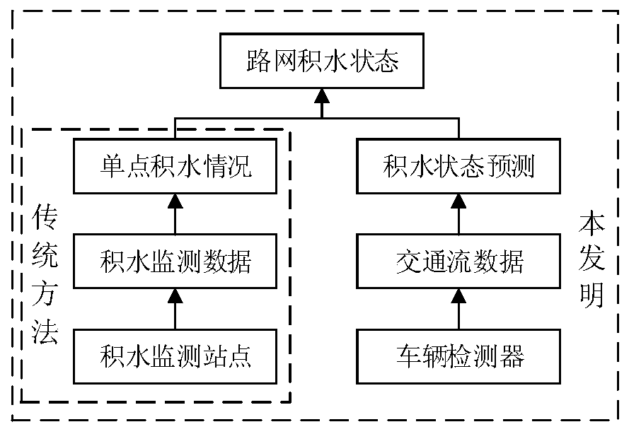
A technology of urban road network and multi-source data, applied in traffic flow detection, traffic control system of road vehicles, instruments, etc. Problems such as the inability to obtain information on the status of water accumulation in the urban road network can achieve the effects of avoiding property losses, improving perception and prediction capabilities, and preventing people from being trapped

Active Publication Date: 2020-07-10
BEIJING RES CENT OF URBAN SYST ENG
View PDF4 Cites 0 Cited by
  • Summary
  • Abstract
  • Description
  • Claims
  • Application Information

AI Technical Summary

Problems solved by technology

However, due to problems such as construction cost, monitoring scope, and practicability, urban rainfall road network water accumulation monitoring stations are generally only built for individual or key locations, and there is no large-scale, high-density implementation of effective monitoring of rainfall and water accumulation in the entire urban area. Monitoring, that is, once there is a heavy rain in the city, only the water accumulation near the road network water accumulation monitoring station can be obtained. It is a kind of water accumulation monitoring at discrete points. Monitoring of stagnant water status

Method used


Image

  • A multi-source data fusion method for predicting urban road network flooding status
  • A multi-source data fusion method for predicting urban road network flooding status
  • A multi-source data fusion method for predicting urban road network flooding status

Examples


Embodiment Construction

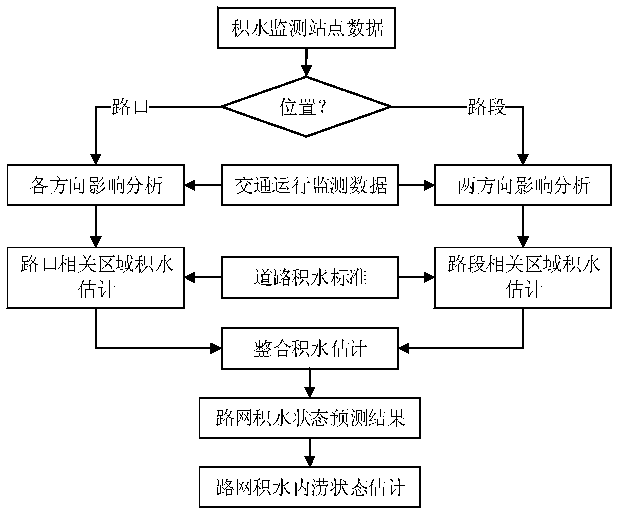
[0048] The technical solution adopted in the summary of the invention will be described in detail below in conjunction with the accompanying drawings, and the main steps are as follows:

[0049]Step 1: Determine the geographical location of the waterlogging monitoring station in the road network and its distance relationship with road sections and intersections.

[0050] Step 2: According to the location of the waterlogging monitoring station in the road network, determine its relevance to the intersection and road section. Assuming that the distance from the road network waterlogging monitoring station to the intersection is d, if d≤100m, the road network waterlogging monitoring station is considered to be located near the intersection. Conversely, if the distance between the road network waterlogging monitoring station and the adjacent intersection exceeds this value, that is, d>100m, it is considered that the road network waterlogging monitoring station is located in the mi...


PUM


Abstract

The invention provides an urban road network water accumulation state prediction method based on multi-source data fusion. In view of the deficiencies of the current road water accumulation monitoring, multi-source monitoring data such as water accumulation monitoring data and traffic operation data are synthetically utilized, the traffic operation characteristics under different water accumulation environments are considered, whether road network water accumulation monitoring stations are built at intersections and road sections is combined, and thus, water accumulation states and predictionanalysis of the intersections or the road sections under different water accumulation states and different traffic operation conditions are given. Based on water accumulation judgment and prediction results of all intersections and all road sections, classification and color division for different water accumulation states of the road are built, a road network water accumulation state prediction map is built, and thus, discrete point water accumulation monitoring is expanded to road network-level water accumulation state analysis, the water accumulation distribution condition and the influenceproportions of roads which are moderately or above influenced by urban waterlogging are obtained, and finally, qualitative and quantitative prediction analysis on the road network water accumulationstates can be realized.

Description

technical field [0001] The invention discloses a method for predicting the state of water accumulation in an urban road network based on multi-source data fusion, and belongs to the field of monitoring the state of water accumulation in roads under urban rainstorm and waterlogging scenarios. Background technique [0002] At present, due to the impact of heavy rains in cities, waterlogging is common in urban areas, resulting in trapped vehicles and personnel, property losses, traffic interruptions and even paralysis. With the acceleration of urbanization in my country, the adverse consequences caused by urban waterlogging have become more and more serious, seriously hindering the sustainable development of cities. In order to improve the monitoring level of waterlogging and avoid various losses caused by waterlogging, the rainfall road network waterlogging monitoring station can effectively and accurately monitor the waterlogging situation after the rainstorm. According to th...

Claims


Application Information

Patent Timeline
Patent Type & Authority Patents(China)
IPC IPC(8): G08G1/01G08G1/048
CPCG08G1/0104G08G1/0125G08G1/048
Inventor 唐少虎朱伟郑建春王晶晶刘梦婷
Owner BEIJING RES CENT OF URBAN SYST ENG
Learn More