
A method for monitoring urban expansion by remote sensing and evaluating urban quality

A technology of urban expansion and remote sensing monitoring, applied in image data processing, instruments, data processing applications, etc., can solve the problems of urban information misclassification, missing classification, accuracy impact, etc., and achieve scientific results

Inactive Publication Date: 2019-01-18
NANJING FORESTRY UNIV +1
View PDF4 Cites 4 Cited by
  • Summary
  • Abstract
  • Description
  • Claims
  • Application Information

AI Technical Summary

Problems solved by technology

At present, the methods of urban information extraction include traditional supervised classification method, index method based on IBI, decision tree method, hybrid spectral analysis method, artificial neural network method, compressed data dimension method, texture analysis technology and object-oriented classification method. During the extraction process, due to the complex environment, image quality and other factors, coupled with the diversity of buildings in the town itself, there is a phenomenon of "same object with different spectrum, different objects with same spectrum", and the extracted town information has misclassification and omissions. , and the accuracy will also be affected
[0005] Since the reform and opening up, China's economy has developed rapidly. Although the number, scale and speed of urban development have been greatly improved, there are still some problems, such as a large number of small towns, scattered, and extremely unbalanced regional development.

Method used


Image

  • A method for monitoring urban expansion by remote sensing and evaluating urban quality
  • A method for monitoring urban expansion by remote sensing and evaluating urban quality
  • A method for monitoring urban expansion by remote sensing and evaluating urban quality

Examples


Embodiment Construction

[0019] A method for remote sensing monitoring of urban expansion and urban quality evaluation, comprising the following steps:

[0020] (1) Atmospheric correction of remote sensing images based on the 6S radiative transfer model 101;

[0021] (2) Remote sensing image geometric correction 102 based on Polynomial model;

[0022] (3) Remote sensing image seamless mosaic 103 based on histogram matching method;

[0023] (4) Remote sensing image reduction processing 104 based on band calculation;

[0024] (5) Urban spatio-temporal information extraction 105 based on comprehensive PII and artificial assistance;

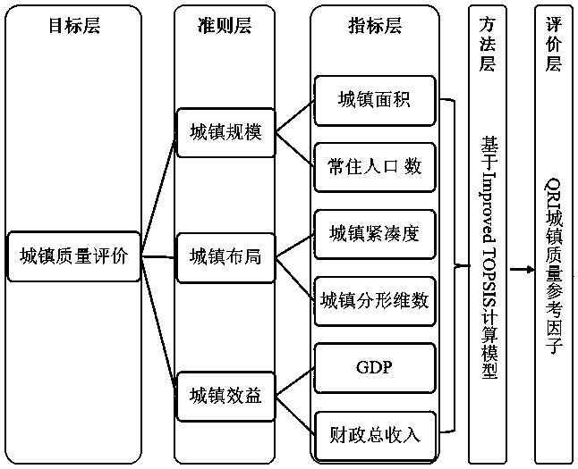
[0025] (6) Building 106 of urban quality reference factors based on Improved TOPSIS.

[0026] The atmospheric correction 101 of the remote sensing image based on the 6S radiation transfer model: perform radiometric calibration according to the data characteristics of the remote sensing image itself, convert the DN value into a radiance value, and perform radiometric calib...


PUM


Abstract

The invention relates to a method for monitoring urban expansion by remote sensing and evaluating urban quality, which comprises the following steps: (1) atmospheric correction of remote sensing imagebased on 6S radiation transfer model; (2) geometric correction of remote sensing image based on Polynomial model; (3) seamless mosaic of remote sensing images based on histogram matching; (4) Remotesensing image subtraction processing based on band operation; (5) Spatio-temporal information extraction of cities and towns based on synthetic PII and artificial aids; (6) Establishment of urban quality reference factors based on Improved TOPSIS. The invention has the advantages that: 1) a complete, effective and scientific remote sensing monitoring and urban quality evaluation method for urban expansion is proposed; 2) the method is suitable for extraction, monitoring and quality evaluation of urban information for various regions; 3) the method provides data support and scientific basis fornew urbanization construction and planning; 4) the method enriches and perfects the relevant theories and methods of urban information management and decision support.

Description

technical field [0001] The invention relates to a method for remote sensing monitoring of urban expansion and urban quality evaluation, which belongs to the technical field of urban development. Background technique [0002] According to the "World Urbanization Prospects" report released by the Department of Economic and Social Affairs of the United Nations Secretariat, the urban population accounted for 55% of the world's population in 2018, while in 1950 the urban population accounted for only 55%. 30% of the world's population, by 2050, it is estimated that 68% of the population will live in urban areas, that is: on a global scale, the population living in cities exceeds half of the total population, and mankind has thus entered the "urban era". With the increase of population, cities will expand naturally. By 2030, it is estimated that there will be 43 megacities in the world with a population of more than 10 million, most of which are located in developing countries and...

Claims


Application Information

Patent Timeline
Patent Type & Authority Applications(China)
IPC IPC(8): G06T5/40G06T5/00G06T7/30G06Q10/06G06Q50/26
CPCG06Q10/06395G06Q50/26G06T5/40G06T7/30G06T5/80
Inventor 朱恒超杨强何立恒郑加柱陈动陈红华何龙江周权平姜月华张洁
Owner NANJING FORESTRY UNIV
Learn More