
Remote Sensing Image Fusion Method

A remote sensing image and fusion method technology, applied in the field of remote sensing, can solve the problems of color cast in fusion results, difficulty in having high spatial and high spectral resolution at the same time, and inability to fully reflect the target object, etc., to improve color fidelity and clarity degree, enhance the effect of detailed information

Inactive Publication Date: 2019-01-01
NORTHEAST INST OF GEOGRAPHY & AGRIECOLOGY C A S
View PDF5 Cites 10 Cited by
  • Summary
  • Abstract
  • Description
  • Claims
  • Application Information

AI Technical Summary

Problems solved by technology

[0002] With the rapid development of modern remote sensing technology, the means of obtaining data by remote sensing are increasing, and various earth observation satellites continue to provide remote sensing data with different spatial resolutions, spectral resolutions, and time resolutions. However, due to the principle of remote sensing satellite imaging Due to the limitations of different and technical conditions, any single information source cannot fully reflect the characteristics of the target object, and it is difficult to have the characteristics of high spatial and high spectral resolution at the same time, so it has certain limitations on the application
[0003] Traditional multispectral images and panchromatic band images of remote sensing images can be realized by fusion methods such as principal component transform, wavelet transform, and HIS transform. There are color casts in the fusion results, and some details are lost.

Method used


Image

  • Remote Sensing Image Fusion Method
  • Remote Sensing Image Fusion Method
  • Remote Sensing Image Fusion Method

Examples


Embodiment Construction

[0045] The following will clearly and completely describe the technical solutions in the embodiments of the present invention with reference to the accompanying drawings in the embodiments of the present invention. Obviously, the described embodiments are only some, not all, embodiments of the present invention. Based on the embodiments of the present invention, all other embodiments obtained by persons of ordinary skill in the art without making creative efforts belong to the protection scope of the present invention.

[0046] The purpose of the present invention is to provide a remote sensing image fusion method, improve color fidelity and clarity, and enhance detailed information of the fusion image.

[0047] In order to make the above objects, features and advantages of the present invention more comprehensible, the present invention will be further described in detail below in conjunction with the accompanying drawings and specific embodiments.

[0048] figure 1 It is a ...


PUM


Abstract

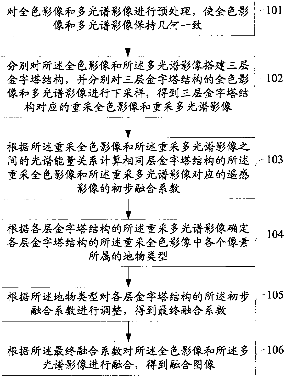
The invention discloses a remote sensing image fusion method. The method comprises the following steps of: constructing three-layer pyramid structures for panchromatic images and multi-spectral imagesrespectively, and sampling down panchromatic images and multi-spectral images of the three-layer pyramid structures respectively to obtain the re-extracted panchromatic images and re-extracted multi-spectral images corresponding to the three-layer pyramid structures; according to the spectral energy relationship between the re-extracted panchromatic images and the re-extracted multispectral images, the preliminary fusion coefficients of the remote sensing images corresponding to the re-extracted panchromatic images and the re-extracted multispectral images with the same pyramid structure arecalculated. According to the restored multi-spectral image, the object type of each pixel in the restored panchromatic image is determined. The initial fusion coefficients of pyramid structures are adjusted according to the geographic features, and the final fusion coefficients are obtained. The panchromatic image and multi-spectral image are fused according to the final fusion coefficients. The remote sensing image fusion method of the invention can improve color fidelity and clarity and enhance detail information of the fusion image.

Description

technical field [0001] The invention relates to the technical field of remote sensing, in particular to a remote sensing image fusion method. Background technique [0002] With the rapid development of modern remote sensing technology, the means of obtaining data by remote sensing are increasing, and various earth observation satellites continue to provide remote sensing data with different spatial resolutions, spectral resolutions, and time resolutions. However, due to the principle of remote sensing satellite imaging Due to the limitations of different and technical conditions, any single information source cannot fully reflect the characteristics of the target object, and it is difficult to have the characteristics of high spatial and high spectral resolution at the same time, so it has certain limitations on the application. [0003] Traditional multispectral images and panchromatic band images of remote sensing images can be realized by fusion methods such as principal ...

Claims


Application Information

Patent Timeline
IPC IPC(8): G06T5/50
CPCG06T5/50G06T2207/10036G06T2207/10041G06T2207/20221
Inventor 王宗明董张玉毛德华贾明明任春颖何兴元
Owner NORTHEAST INST OF GEOGRAPHY & AGRIECOLOGY C A S
Learn More