Ground-based navigation and positioning method and system with digital terrestrial multimedia broadcasting synchronization

A technology for multimedia broadcasting, navigation and positioning, which is applied in the field of ground-based navigation and positioning of digital terrestrial multimedia broadcasting synchronization, and can solve the problems such as the synchronization effect of ground-based navigation beacon transmitters.

Active Publication Date: 2018-12-07
北京因子图导航技术有限公司
View PDF14 Cites 4 Cited by
  • Summary
  • Abstract
  • Description
  • Claims
  • Application Information

AI Technical Summary

Problems solved by technology

[0003] The use of ground-based navigation beacons for navigation and positioning is an important backup and alternative means of satellite navigation, but what must be solved is the problem of low-cost and high-precision time synchronization between ground-based navigation beacon transmitters
If you still rely on satellite navigation positioning and timing to achieve time synchronization between transmitters, if satellite navigation positioning is not available, it is likely that the synchronization between ground-based navigation beacon transmitters will also be affected

Method used


Image

  • Ground-based navigation and positioning method and system with digital terrestrial multimedia broadcasting synchronization
  • Ground-based navigation and positioning method and system with digital terrestrial multimedia broadcasting synchronization
  • Ground-based navigation and positioning method and system with digital terrestrial multimedia broadcasting synchronization

Examples


Embodiment 1

[0074] The digital terrestrial multimedia broadcasting described in the present invention, namely DTMB (Digital Terrestrial MultimediaBroadcasting) technology refers to "GB20600-2006 Digital TV Terrestrial Broadcasting Transmission System Frame Structure, Channel Coding and Modulation" and its evolution based on my country's terrestrial digital television transmission standard Technology represented by digital terrestrial television broadcasting technology.

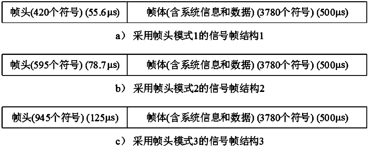
[0075] figure 2 It is a four-layer structure of multiframe for digital terrestrial multimedia broadcasting signals. In the figure, h represents hour, min represents minute, ms represents millisecond, us represents microsecond, am represents morning, pm represents afternoon, and PN sequence is a pseudo-random sequence. According to "GB20600-2006 Digital TV Terrestrial Broadcasting Transmission System Frame Structure, Channel Coding and Modulation", the digital terrestrial multimedia broadcasting data frame structure has f...

Embodiment 2

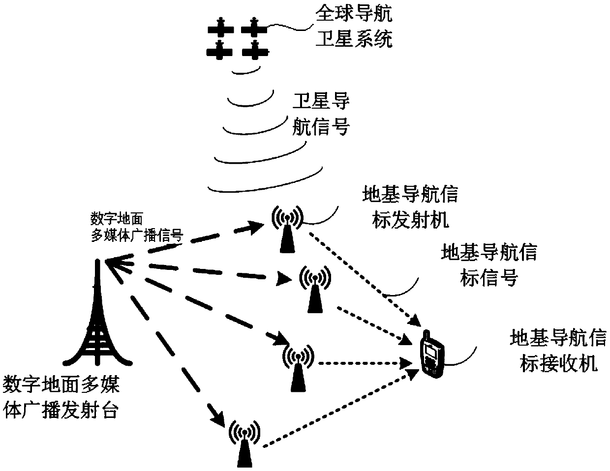
[0079] A ground-based navigation and positioning system synchronized with digital terrestrial multimedia broadcasting, such as figure 1 , Figure 4 , Figure 5 shown.

[0080] image 3 It is a block diagram of a ground-based navigation and positioning system synchronized with digital terrestrial multimedia broadcasting according to the present invention. like image 3 As shown, the ground-based navigation and positioning system synchronized with digital terrestrial multimedia broadcasting according to the present invention includes a digital terrestrial multimedia broadcasting transmitter, a global navigation satellite system, a ground-based navigation beacon transmitter and a ground-based navigation beacon receiver.

[0081] The digital terrestrial multimedia broadcasting transmitting station transmits digital terrestrial multimedia broadcasting signals.

[0082] The global navigation satellite system transmits satellite navigation signals. Generally, global satellite p...

Embodiment 3

[0108] A method for positioning by a ground-based navigation and positioning system synchronized with digital terrestrial multimedia broadcasting, such as Image 6 , Figure 7 and Figure 8 shown.

[0109] Image 6 It is a flowchart of a ground-based navigation and positioning method synchronized with digital terrestrial multimedia broadcasting according to the present invention. like Image 6 As shown, the method for positioning according to the digital terrestrial multimedia broadcasting synchronous ground-based navigation and positioning system of the present invention mainly includes the following steps:

[0110] 1) The digital terrestrial multimedia broadcasting transmitting station transmits the digital terrestrial multimedia broadcasting signal, and sets the universal reference time of arrival T1 of the superframe header pseudo-random sequence of the digital terrestrial multimedia broadcasting signal.

[0111] 2) The ground-based navigation beacon transmitter track...


PUM


Abstract

The invention discloses a ground-based navigation and positioning method and system with digital terrestrial multimedia broadcasting synchronization. The system is mainly composed of a digital terrestrial multimedia broadcasting transmitting station, a global navigation satellite system, ground-based navigation beacon transmitters and a ground-based navigation beacon receiver. The method for positioning of the ground-based navigation positioning system comprises: step one, the transmitting station transmits a digital terrestrial multimedia broadcast signal; step two, the digital terrestrial multimedia broadcast signal is captured; step three, a time difference Dt between arrival time T2 of a super-frame header pseudo-random sequence of the digital terrestrial multimedia broadcast signal and universal reference arrival time T1 is calculated; step four, the ground-based navigation beacon transmitters transmit ground-based navigation beacon signals at time T3; and step five, the ground-based navigation beacon receiver is located. According to the invention, the multiple ground-based navigation beacon transmitters carry out time synchronization by using digital terrestrial multimedia broadcast signals, so that a problem of reliance on satellite navigation by existing systems is solved.

Description

technical field [0001] The invention relates to radio navigation technology, in particular to a ground-based navigation and positioning method and system synchronized with digital terrestrial multimedia broadcasting. Background technique [0002] In recent years, with the development of artificial intelligence technology, drones and unmanned vehicles have been widely used. The existing unmanned technology mostly uses satellite positioning and navigation system as the means of navigation, positioning and timing. The main problem is that the ground signal is weak, and it is easy to cause the signal to be unavailable due to occlusion and interference. With the maturity of satellite navigation jamming and countermeasure technology, as well as military confrontation among major powers, people's concerns about the availability of satellite navigation systems are increasing. [0003] The use of ground-based navigation beacons for navigation and positioning is an important backup a...

Claims


Application Information

Patent Timeline
IPC IPC(8): G01S19/42H04B7/185
CPCG01S19/42H04B7/18523
Inventor 李璨
Owner 北京因子图导航技术有限公司
Why Eureka
Try Eureka