
Establishment method for urban three-dimensional visualization underground pipeline system based on Cesium

A technology of three-dimensional modeling of cities and underground pipelines, which is applied in the field of establishment of urban three-dimensional visualized underground pipeline systems, can solve the problems of showing the overall picture of the city and the layout of underground pipelines in front of people, and the low efficiency of underground pipeline network maintenance management, etc., to achieve Easy to find and repair the effect of underground pipe network

Pending Publication Date: 2018-11-27
安徽美图信息科技有限公司
View PDF8 Cites 5 Cited by
  • Summary
  • Abstract
  • Description
  • Claims
  • Application Information

AI Technical Summary

Problems solved by technology

[0005] The purpose of the present invention is to provide a method for establishing a Cesium-based urban three-dimensional visualized underground pipeline system, by collecting urban geographical topography information and urban network management data information, and using remote sensing image technology, DEM technology and Cesium to build a three-dimensional urban model and underground pipeline network The model solves the problems of low maintenance and management efficiency of the existing underground pipeline network and the inability to effectively display the overall picture of the city and the layout of underground pipelines in front of people

Method used


Image

  • Establishment method for urban three-dimensional visualization underground pipeline system based on Cesium

Examples


Embodiment Construction

[0023] The following will clearly and completely describe the technical solutions in the embodiments of the present invention with reference to the accompanying drawings in the embodiments of the present invention. Obviously, the described embodiments are only some, not all, embodiments of the present invention. Based on the embodiments of the present invention, all other embodiments obtained by persons of ordinary skill in the art without creative efforts fall within the protection scope of the present invention.

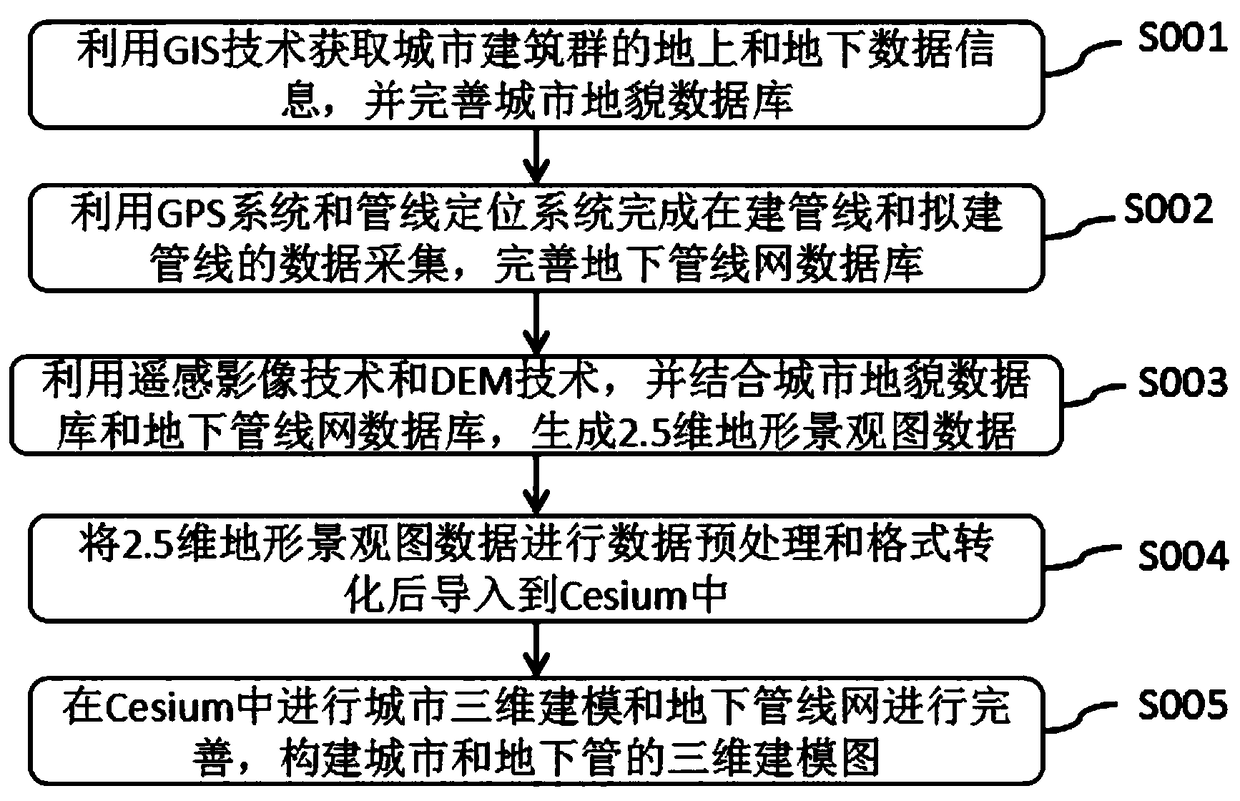
[0024] Such as figure 1 As shown, the present invention is a method for establishing a Cesium-based urban three-dimensional visualization underground pipeline system, comprising the following steps:

[0025] S001, use GIS technology to obtain above-ground and underground data information of urban buildings, provide data basis for building three-dimensional models of cities, and improve urban landform databases;

[0026] S002, use the GPS system and pipeline positi...


PUM


Abstract

The invention discloses an establishment method for an urban three-dimensional visualization underground pipeline system based on Cesium, and relates to the field of virtual three-dimensional pipelines. The method comprises the following steps: S001, acquiring above-ground and underground data information of an urban building group by using a GIS technology, and perfecting an urban geomorphological database; S002, using a GPS system and a pipeline positioning system to complete data collection of pipeline under construction and pipeline to be constructed, and perfecting an underground pipelinenetwork database; S003, using a remote sensing image technology and a DEM technology, combined with the urban geomorphological database and the underground pipeline network database, to generate 2.5-dimensional topographic landscape map data. The method provides convenience for people to maintain underground pipelines and future urban layout by collecting urban geography and geomorphology information and urban network management data information, and the remote sensing image technology, the DEM technology and the Cesium are used to build an urban three-dimensional model and an underground pipeline network model.

Description

technical field [0001] The invention belongs to the field of virtual three-dimensional pipelines, in particular to a method for establishing an urban three-dimensional visualized underground pipeline system based on Cesium. Background technique [0002] With the rapid development of my country's economy, the scale of cities is also constantly expanding, and the laying of urban underground pipe networks is also increasing. Urban underground pipe networks are responsible for the tasks of information transmission, energy delivery, water supply and drainage, etc. Therefore, it is known as the lifeline of the city. However, with the rapid development of the city, the material flow and energy flow in the city gradually increase, which makes the spatial distribution of urban underground pipelines more and more narrow. Therefore, it is of great significance to establish a 3D model of the city and underground pipeline network. [0003] The traditional underground professional pipelin...

Claims


Application Information

Patent Timeline
IPC IPC(8): G06T17/00G06F17/50
CPCG06T17/00G06F30/18
Inventor 陈颖
Owner 安徽美图信息科技有限公司
Learn More