
Arcgis-based industrial and mining enterprise information control system

A technology for information control and industrial and mining enterprises, applied in the field of information processing, can solve problems such as increased production management expenditure, lack of strong pertinence, and huge knowledge system, and achieve the effect of frequent information updates, increased convenience, and expanded richness

Pending Publication Date: 2018-11-06
TIANJIN UNIVERSITY OF SCIENCE AND TECHNOLOGY
View PDF8 Cites 2 Cited by
  • Summary
  • Abstract
  • Description
  • Claims
  • Application Information

AI Technical Summary

Problems solved by technology

The commercialized GIS software has a good mapping effect, and it faces many non-amateur categories. However, it does not have a strong pertinence, and its knowledge system is often relatively large in direct use, and the software operation process is too specialized and complicated. and other issues, which virtually increases the expenditure in production management

Method used


Image

  • Arcgis-based industrial and mining enterprise information control system

Examples


Embodiment Construction

[0012] Embodiments of the present invention will be described in further detail below in conjunction with the accompanying drawings.

[0013] The present invention adopts component type GIS (Components GIS, is called for short ComGIS), uses the API of ArcGIS Engine to realize system main frame, and data engine adopts local cache data (adopts mdb database connection display layer); Server utilizes ArcGIS SDE (layer editing, version control, etc.) to drive the basic layer data, and Arcgis Server to support the satellite raster map.

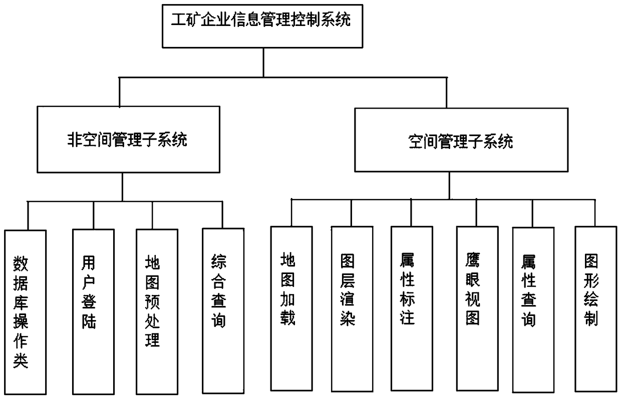
[0014] An Arcgis-based industrial and mining enterprise information control system, such as figure 1 As shown, including non-space management control subsystems, space management control subsystems and databases. Among them, the non-space management control subsystem is composed of a database operation module, a user login module, a map processing module and a comprehensive query module. The space management control system is composed of a map load...


PUM


Abstract

The invention relates to an Arcgis-based industrial and mining enterprise information control system. The system comprises a non-space management control subsystem, a space management control subsystem and a database, wherein the non-space management control subsystem consists of a database operation class module, a user login module, a map processing module and a comprehensive query module; the space management control subsystem consists of a map loading module, a map layer rendering module, an attribute labeling module, an eagle eye view module, an attribute query module and a map layer drawing module; and the database adopts an Sql Server 2008 database and Access database combined manner. The system is reasonable in design and supports operations such as space attribute query and map layer edition, so that the operation convenience of the system is increased, the problems of frequent information updating and high mapping expenditure of related departments in enterprise land management are effectively solved, and the system can be widely applied to the management carried out on industrial and mining enterprises in management ranges by government related departments.

Description

technical field [0001] The invention belongs to the technical field of information processing, in particular to an Arcgis-based industrial and mining enterprise information control system. Background technique [0002] At present, there are many complete GIS-based commercial software at home and abroad, such as ESRI's ArcGIS series software, MapInfo software, etc., which have been successfully used in various industries. The commercialized GIS software has a good mapping effect, and it faces many non-amateur categories, but it does not have a strong pertinence, and its knowledge system is often relatively large in direct use, and the software operation process is too specialized and complicated And other problems, which virtually increased the expenditure in production management. Contents of the invention [0003] The purpose of the present invention is to overcome the deficiencies of the prior art, and propose an Arcgis-based industrial and mining enterprise information...

Claims


Application Information

Patent Timeline
IPC IPC(8): G06Q10/06G06Q50/02G06F17/30
CPCG06Q10/0631G06Q50/02
Inventor 周婧杨兴国
Owner TIANJIN UNIVERSITY OF SCIENCE AND TECHNOLOGY
Learn More