
Splicing method of UAV-borne high spectral line array remote sensing image

A remote sensing image and hyperspectral technology, applied in the field of remote sensing image processing, can solve the problem of small coverage of a single image of UAV

Active Publication Date: 2018-11-02
CHINA UNIV OF MINING & TECH (BEIJING)
View PDF4 Cites 9 Cited by
  • Summary
  • Abstract
  • Description
  • Claims
  • Application Information

AI Technical Summary

Problems solved by technology

[0004] The purpose of the present invention is to provide a splicing method for UAV-borne hyperspectral line array remote sensing images. The front and rear spectral distortion is very small, and the final stitching result has real geographic coordinates

Method used


Image

  • Splicing method of UAV-borne high spectral line array remote sensing image
  • Splicing method of UAV-borne high spectral line array remote sensing image
  • Splicing method of UAV-borne high spectral line array remote sensing image

Examples


Embodiment Construction

[0044] The technical solutions in the embodiments of the present invention will be clearly and completely described below in conjunction with the accompanying drawings in the embodiments of the present invention. Obviously, the described embodiments are only some of the embodiments of the present invention, not all of them. Based on the embodiments of the present invention, all other embodiments obtained by persons of ordinary skill in the art without making creative efforts belong to the protection scope of the present invention.

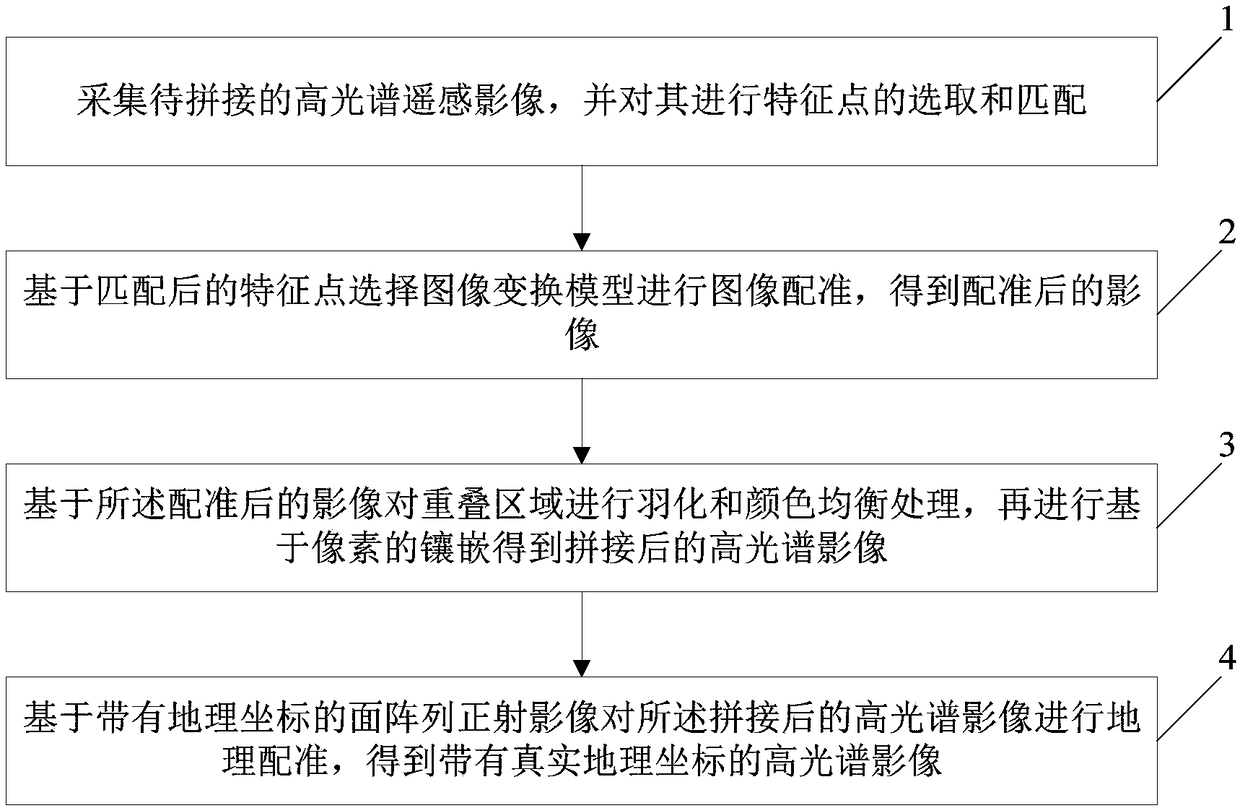
[0045] Embodiments of the present invention will be further described in detail below in conjunction with the accompanying drawings, as figure 1 Shown is a schematic flow chart of the splicing method of the UAV-borne hyperspectral line array remote sensing image provided by the embodiment of the present invention, and the method includes:

[0046] Step 1. Collect hyperspectral remote sensing images to be stitched, and select and match feature point...


PUM


Abstract

The invention discloses a splicing method of a UAV-borne high spectral line array remote sensing image. The splicing method comprises the steps of collecting a to-be-spliced high spectral remote sensing image, and selecting and matching feature points of the image; selecting an image transformation model according to the matched feature points and performing image registration so as to acquire a registered image; performing feathering and color balancing treatment on overlapped areas according to the registered image, and embedding based on pixels so as to obtain a spliced high spectral image;and performing geographic registration on the spliced high spectral image according to a plane array ortho-image with geographical coordinates, so as to obtain a high spectral image with real geographical coordinates. Through adoption of the method, the problem that a UAV single image has a small coverage is solved, visual effect is guaranteed and spectral deformation before and after image splicing is small, and the final splicing result has real geographical coordinates.

Description

technical field [0001] The invention relates to the technical field of remote sensing image processing, and in particular to a splicing method of hyperspectral line array remote sensing images carried by an unmanned aerial vehicle. Background technique [0002] Hyperspectral technology uses a large number of very narrow electromagnetic wave bands to obtain relevant data from objects of interest, which contains rich triple information of space, radiation and spectrum. Its most important feature and symbol is the combination of spectrum and image. This is the current international Frontiers of remote sensing technology. Due to the high spectral resolution of hyperspectral remote sensing images, which can provide more abundant information on the earth's surface, it has attracted great attention and been widely used by scholars at home and abroad. Its application fields have covered all aspects of earth science and become a geological Effective technical means in the fields of ...

Claims


Application Information

Patent Timeline
Patent Type & Authority Applications(China)
IPC IPC(8): G06T5/50G06T3/40G06T7/30G06T7/90
CPCG06T3/4038G06T5/50G06T7/30G06T7/90G06T2207/10032Y02A40/10
Inventor 易俐娜
Owner CHINA UNIV OF MINING & TECH (BEIJING)
Learn More