
Fine granularity classification-based unmanned aerial vehicle identifying and locating method

A positioning method and UAV technology, which is applied in character and pattern recognition, image analysis, computer parts, etc., can solve the problems of inaccurate recognition and positioning of UAVs, and achieve the effect of accurate positioning

Active Publication Date: 2018-10-26
OCEAN UNIV OF CHINA
View PDF7 Cites 6 Cited by
  • Summary
  • Abstract
  • Description
  • Claims
  • Application Information

AI Technical Summary

Problems solved by technology

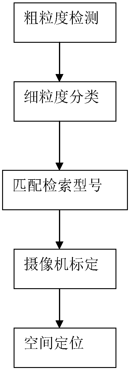
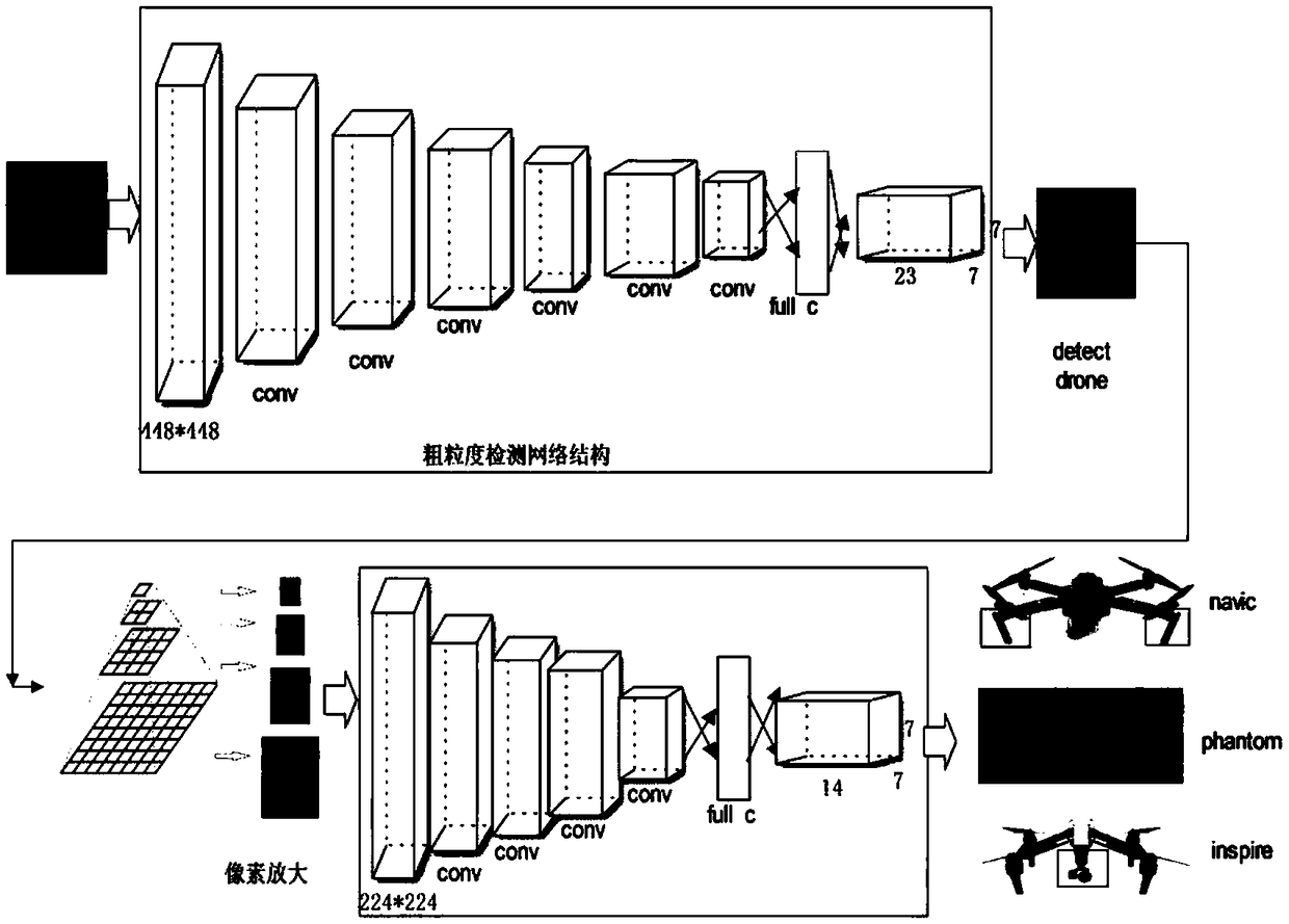
[0005] Aiming at the deficiencies in the prior art, the present invention provides a UAV identification and positioning method based on fine-grained classification. Based on the fine-grained classification after object detection, the identified UAV model and UAV model Relevant external structure information is retrieved from the library information, combined with the internal parameters of the camera, the two-dimensional coordinates of the drone are mapped into three-dimensional coordinates to determine the position of the drone in the three-dimensional space, and the identification and positioning of the drone are not accurate. The problem

Method used


Image

  • Fine granularity classification-based unmanned aerial vehicle identifying and locating method
  • Fine granularity classification-based unmanned aerial vehicle identifying and locating method
  • Fine granularity classification-based unmanned aerial vehicle identifying and locating method

Examples


Embodiment Construction

[0032] The present invention will be further described below in conjunction with the accompanying drawings and specific embodiments.

[0033] Such as figure 1 As shown, in the UAV identification and positioning method based on fine-grained classification of the present invention, in order to realize fine-grained classification, the UAV data set library is first established. At present, there is no data set library that can meet the requirements of fine-grained classification and detection. Existing ones can only satisfy coarse-grained classification. The invention collects a huge data set satisfying many types of drones and parameter information through experiments, establishes a computer vision database satisfying fine-grained classification, and performs fine-grained classification of drones. Compared with the existing data set database, the computer vision database of the present invention can see the dynamic visualization of the data set and mark the detailed model inform...


PUM


Abstract

The invention discloses a fine granularity classification-based unmanned aerial vehicle identifying and locating method. Based on fine granularity classification after object coarse granularity detection, specific external structure information of an unmanned aerial vehicle is searched out according to an identified unmanned aerial vehicle type and unmanned aerial vehicle type library information;in combination with internal parameters of a camera, two-dimensional coordinates of the unmanned aerial vehicle are mapped into three-dimensional coordinates to determine the position, in a three-dimensional space, of the unmanned aerial vehicle; and through continuous three-dimensional coordinate information of frame pictures, trajectory information of the unmanned aerial vehicle can be obtainedin the three-dimensional space. The method solves the problem of inaccurate identifying and locating of the unmanned aerial vehicle in the prior art.

Description

technical field [0001] The invention belongs to the technical field of unmanned aerial vehicles, in particular to an identification and positioning method for unmanned aerial vehicles based on fine-grained classification. Background technique [0002] In recent years, UAV technology has developed rapidly and is widely used in various fields, which also puts forward higher requirements for UAV detection, identification and positioning technology. At present, there are many solutions for the detection, identification and positioning of UAVs, including satellite positioning methods, radar and camera combination methods, etc. The detection effect is poor and it is easily interfered by external signals. [0003] For this reason, technicians have improved. For example, the invention patent with application number 2016111441100 discloses a UAV identification system for UAV control based on electronic information, including remote sensing aircraft, satellites, ground signal transce...

Claims


Application Information

Patent Timeline
Patent Type & Authority Applications(China)
IPC IPC(8): G06T7/70G06T7/80G06K9/62G06F17/30
CPCG06T7/70G06T7/80G06F18/24
Inventor 刘昊魏志强殷波曲方超
Owner OCEAN UNIV OF CHINA
Learn More