Attitude adjustment method of agile satellite imaging along inclined stripe during maneuvering

An adjustment method and a technology of oblique strips, which are applied in the directions of motor vehicles, attitude control, space navigation equipment, etc., can solve the problems of weak coverage and inability to meet the accuracy of satellite pointing to the ground.

Active Publication Date: 2018-10-02
AEROSPACE DONGFANGHONG SATELLITE
View PDF5 Cites 6 Cited by
  • Summary
  • Abstract
  • Description
  • Claims
  • Application Information

AI Technical Summary

Problems solved by technology

[0004] The technical problem solved by the present invention is: aiming at the problem that the coverage ability of the parallel strip scanning method in the current prior art is relatively weak, and the existing oblique strip scanning method cannot meet the pointing accuracy of satellites with a small camera field of view to the ground, a new method is proposed. A Method of Attitude Adjustment for Oblique Strip Imaging During Agile Satellite Maneuvering

Method used


Image

  • Attitude adjustment method of agile satellite imaging along inclined stripe during maneuvering
  • Attitude adjustment method of agile satellite imaging along inclined stripe during maneuvering
  • Attitude adjustment method of agile satellite imaging along inclined stripe during maneuvering

Examples


Embodiment Construction

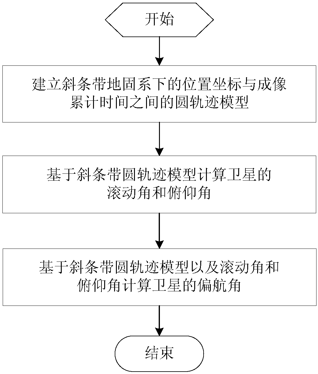
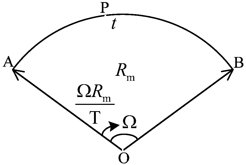
[0064] An attitude adjustment method for imaging along oblique strips during agile satellite maneuvers. According to the imaging principle of agile optical remote sensing satellites, the following can be established: Figure 4 The imaging geometry model shown: the orbital coordinate system of the satellite is S-X o Y o Z o , S is the center of mass of the satellite, Z o axis pointing to the center of the earth, X o The axis points to the direction of flight, Y o Determined by the right-hand rule, the sub-satellite point is S′, and P is any point on the oblique strip taken by the satellite at the current time t. The optical axis of the camera coincides with the yaw axis of the satellite body coordinate system. Assuming that the initial moment of the satellite body coordinate system coincides with the orbit coordinate system, the 1-2-3 attitude sequence is adopted.

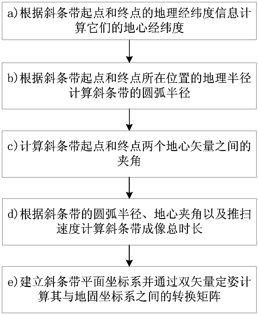
[0065] The oblique strip is defined as: two points A and B on the surface of the earth are known, then the ...


PUM


Abstract

The invention discloses an attitude adjustment method of an agile satellite imaging along an inclined stripe during maneuvering. The method comprises the following steps: computing a position vector of a photography point in an earth-fixed coordinate system at any imaging moment through the establishment of a circle locus model between the position coordinate of the inclined stripe in the earth-fixed coordinate system and the imaging accumulated time, and further computing the rolling angle, pitch angle and drift angle of the satellite at the moment. More accurate satellite expected attitude can be obtained on the premise that the influence of ellipticity of the earth is taken into account, the requirement on high pointing to the ground is met, the situation that a target cannot be coveredwhen the field angle of a camera is small is effectively avoided, the reliability is high, and the stability is good.

Description

technical field [0001] The invention relates to an attitude adjustment method for imaging along an oblique strip during an agile satellite maneuver, which is used for realizing the attitude adjustment of a camera carrier during the imaging process along a given oblique strip, belonging to the technical field of spacecraft attitude adjustment. Background technique [0002] Traditional optical remote sensing agile satellites generally rely on the orbital motion of the satellite to achieve push-broom imaging of the target area. The attitude of the satellite remains fixed during the entire imaging process, and the obtained imaging strips are parallel to the off-satellite line. This imaging method has weak imaging coverage along the east-west direction. For targets with a large width in the east-west direction, coverage must be achieved by splicing multiple parallel strips, and the coverage efficiency is very low. With the rapid improvement of attitude maneuverability, new agile ...

Claims


Application Information

Patent Timeline
IPC IPC(8): G01C1/00G05D1/08
CPCB64G1/244G01C1/00
Inventor 陈雄姿谢松王抒雁赵键李志壮刘思远
Owner AEROSPACE DONGFANGHONG SATELLITE
Why Eureka
Try Eureka